
Tuxtla Gutiérrez facts for kids
Quick facts for kids
Tuxtla Gutiérrez
Coyatoc
|
|||
|---|---|---|---|
|
City and municipality
|
|||
| Tuxtla Gutiérrez | |||
     Top: Tuxtla Gutiérrez at night; middle: San Marcos Cathedral, Tuxtla Gutiérrez Municipal Hall; Bottom: Tuxtl Gutiérrez City Museum, Bonampak Theatre
|
|||
|
|||

Location in Chiapas
|
|||

Tuxtla Gutiérrez
Location in Mexico
|
|||
| Country | |||
| State | |||
| Village of Coyatoc | 400 BC | ||
| Tōchtlān | 1486 | ||
| San Marcos Tuxtla | 1748 | ||
| Tuxtla Gutiérrez | May 31, 1848 | ||
| Area | |||
| • Municipality | 334.90 km2 (129.31 sq mi) | ||
| Elevation
of seat
|
522 m (1,713 ft) | ||
| Population
(2020)
|
|||
| • Municipality | 604,147 | ||
| • Density | 1,797.7/km2 (4,656/sq mi) | ||
| • Seat | 578,830 | ||
| • Metro Area | 848,274 | ||
| Demonym(s) | Tuxtleco (a) | ||
| Metro area GDP (PPP, constant 2015 values) | |||
| • Year | 2023 | ||
| • Total | $7.4 billion | ||
| • Per capita | $8,300 | ||
| Time zone | UTC−6 (CST) | ||
| • Summer (DST) | UTC−5 (CDT) | ||
| Postal code (of seat) |
29000 - 29100
|
||
| Area code(s) | 961 | ||
| Climate | Tropical savanna climate | ||


Tuxtla Gutiérrez, often called Tuxtla, is the capital city of Chiapas, a state in southeastern Mexico. It is the largest city in Chiapas and the center of its busiest area. Tuxtla is a hub for government, businesses, and services. It has grown very quickly over the last 40 years.
Unlike some other places in Chiapas, Tuxtla is not a main tourist spot itself. However, it is a key travel center for people visiting the state. It has a large airport and a busy bus station.
Contents
History of Tuxtla Gutiérrez

The Zoque were the first to live in this area long ago. They called the valley Coyatoc, which means 'land or house of rabbits'. Later, the Aztecs came between 1486 and 1505. They named the place Tuchtlan, which also means 'land of rabbits' in their language.
After the Spanish took control in 1528, Dominican monks built a monastery nearby. There is no exact date for Tuxtla's founding. But we know that in the 1500s, Dominican monks gathered the scattered Zoque people. They organized them into communities around churches. A church for San Marcos (Saint Mark) was built for one of these communities in 1560.
The town of San Marcos Tuxtla was first written about in 1748. By 1768, it became the main town for a local government area in Chiapas.
In 1813, the King of Spain officially recognized the village as a "villa." It had about 5,000 people, and three-quarters of them were Zoques. In 1821, the town declared its independence from both Spain and the government of Guatemala. Other parts of Chiapas did the same. However, neither Guatemala nor Mexico accepted this. Tuxtla and the state of Chiapas officially became part of Mexico on September 14, 1824, after a public vote.
The city was officially renamed Tuxtla Gutiérrez on May 31, 1848. This was done by Governor Fernando Nicolás Maldonado. It honored Joaquín Miguel Gutiérrez, a former governor who helped Chiapas join Mexico. The city became the capital of Chiapas on August 11, 1892. It took over from San Cristóbal de las Casas.
The first library in Chiapas was opened here in 1910.
During the Mexican Revolution, a group called "The Sons of Tuxtla" was formed in 1911. In 1914, troops supporting Venustiano Carranza took control of the city. Chiapas was reorganized into a new system of local governments in 1915. Tuxtla Gutiérrez became the head of one of these. Some people in the state did not like Carranza's policies. They burned the state government building in 1915, destroying many old records.
In 1941, the city government moved to a new building. Later, in 1982, the city hall moved again to its current spot.
The Diocese of Tuxtla was created in 1965. This made the San Marcos church a cathedral. It became an archdiocese in 2010. The city grew very fast starting in the 1970s. In 1973, the nearby area of Terán became part of Tuxtla. The first big fair of Chiapas was held in 1980. Pope John Paul II visited the city in 1990.
In the 1990s, some parts of Chiapas had problems with the EZLN or Zapatista uprising. Most of their actions were in the countryside. However, Tuxtla was also affected. Some people moved into the city from rural areas during this time.
In 2011, the government of Guatemala announced it would open a consulate in Tuxtla. This was to help Guatemalan citizens who travel through Mexico or live there.
About the City
Tuxtla is the largest and most developed city in Chiapas. It is growing very quickly. The city is clean and mostly focused on business. It has wide, busy streets filled with cars, taxis, and buses. You can find modern shopping malls and traditional open-air markets.
In 2011, Tuxtla was the first city in Mexico to be called a "safe city." This was because it has a very low crime rate and good programs to prevent crime. The Financial Times and FDi magazine have also called Tuxtla one of the "cities of the future." They looked at its economy, people, costs, quality of life, and business environment.


The city's center is a large square called the Plaza Cívica. Government buildings, like the city and state offices, surround it. On one side is the most important landmark, the Catedral de San Marcos (Saint Mark's Cathedral). It is named after the city's patron saint, Mark the Evangelist. The church was built in the 1500s and has been changed many times. Its back part is the only one left from the colonial era in Chiapas. You can still see old paintings there. The church's current look is mostly white and comes from its last renovation in the 1980s. A special feature is its 48 bells that ring every hour. Statues of the Apostles also appear on the bell tower.
Tuxtla has many nice parks and green spaces. Madero Park is a green area with various museums and cultural centers. These include the Dr. Faustino Miranda Botanical Garden. It covers four hectares along the Sabinal River. Across from the garden is a botanical museum with many types of wood from the state. There is also a natural history museum with preserved animals, plants, and artifacts from Chiapas's past.
The Parque Jardín de la Marimba (Marimba Park) is named after the marimba, a musical instrument important to the state. The park was created in 1993 as a family meeting place. It has many trees, colonial-style benches, and a central kiosk. Marimba bands play here, and older couples often come to dance.

On the edge of the city is the El Zapotal Ecological Reserve. It is home to the Zoológico Miguel Alvarez del Toro Zoo, or ZooMAT. The zoo covers 100 hectares and was founded in 1942. ZooMAT is considered one of the best zoos of its kind in Latin America. It shows, studies, protects, and saves native species of Chiapas. The zoo is known for its work with the quetzal bird. It was the first to breed this bird in captivity in the 1970s. The zoo's design fits the natural land. It only shows animals from the region. It has 1,400 animals from 220 species. These include jaguars, tapirs, macaws, spider monkeys, howler monkeys, and quetzals. Over 150 species roam freely in natural areas. Some animals like deer, iguanas, and small birds come close to visitors. Sixty of the species here are in danger of disappearing.

The largest museum in the city is the Museo Regional de Antropología e Historia. It is one of the most important museums of its kind in Mexico. The building was built in a modern style between 1979 and 1982. Its design won an award in Bulgaria in 1985. The museum's collection shows the history of the state. It has two main halls: one for archeology and one for history after the Spanish conquest.
Next to it is the Museo de Paleontología "Eliseo Palacios Aguilera". It opened in 2002 and is the only museum of its type in the state. It has over 200 fossils, all from Chiapas. These fossils are from 300 million to 10,000 years old. The main hall has a reconstruction of a Megatherium, a giant sloth. There is also a display about the state's amber, with pieces that have insects and spiders inside.
The Chiapas Museum of Science and Technology is an interactive museum for all ages. It shows new ideas in modern times. It has halls about Earth and the Universe, Life and Humans, and Communications and Tools.
The Mercado de los Ancianos is a large traditional market. It is located southeast of the city center, near the zoo. You can find fresh flowers, meat, seafood, clothes, and more. It has an outdoor café that serves dishes made from market ingredients.
The Instituto de las Artesanias y Productos de Chiapas (Institute of Handcrafts and Products of Chiapas), also called the Casa de Artesanías, opened in 1980. It is a large purple building on the city's main street. The government runs it to promote traditional products from Chiapas. These include textiles, clothing, toys, ceramics, wood sculptures, and real amber jewelry. It also has an Ethnographic Museum. This museum shows how different indigenous groups in Chiapas live. It has displays of rural villages and how crafts are made. It also sells coffee and local candies.
The Casa de la Cultura of the city is on Avenida 1a Ponente Norte. Two other important churches are the Santo Domingo Parish and the Santo Niño de Atocha Temple.
The city is the local government for 83 other communities. These communities cover an area of 334.90 km2. It shares borders with the towns of San Fernando, Osumacinta, Chiapa de Corzo, Suchiapa, Ocozocoautla, and Berriozábal.
Metropolitan Area
The metropolitan area of Tuxtla Gutiérrez includes five towns. Two are central, and three are surrounding. It is centered around the connected urban areas of Tuxtla Gutiérrez and Chiapa de Corzo. Berriozábal was added in 2010, and San Fernando and Suchiapa in 2015.
This area covers two economic regions of Chiapas. It also spans three federal electoral districts.
In 2020, the population was 848,274. This makes it the 25th most populated area in Mexico.
| Municipality | State | Type | Area (km2) | 2020 Census | 2010 Census | Change |
|---|---|---|---|---|---|---|
| Tuxtla Gutiérrez | Chiapas | Core | 334.9 | 604,147 | 553,374 | +9.18% |
| Chiapa de Corzo | Chiapas | Core | 830.6 | 112,175 | 87,603 | +28.05% |
| Berriozábal | Chiapas | Peripheral | 352.0 | 64,632 | 43,179 | +49.68% |
| San Fernando | Chiapas | Peripheral | 359.5 | 41,793 | 33,060 | +26.42% |
| Suchiapa | Chiapas | Peripheral | 283.9 | 25,627 | 21,045 | +21.77% |
| Total | 2,160.9 | 848,274 | 738,261 | +14.90% |
Population and People
| Historical population | ||
|---|---|---|
| Year | Pop. | ±% |
| 1970 | 66,851 | — |
| 1980 | 131,096 | +96.1% |
| 1990 | 289,626 | +120.9% |
| 2000 | 424,579 | +46.6% |
| 2010 | 537,102 | +26.5% |
| 2020 | 578,830 | +7.8% |
| INEGI Population Census. | ||
In 2020, the municipality had a total population of 604,147 people. The city of Tuxtla Gutiérrez itself had 578,830 residents. This makes it the 31st most populated city in Mexico.
More than half of the people in the Central Valley region of Chiapas live in Tuxtla. Most residents are young, with 66% under thirty years old. The average age is twenty-three. The population is growing by about four percent each year. This means the number of people could double in less than twenty years.
Most of the population (99.56%) lives in three urban areas. The rest live in 81 smaller rural communities. The city is much more crowded than the rest of the region or state. The average woman has 2.27 children, which is lower than the state average. Some people move to Tuxtla from other Mexican states like Veracruz and State of Mexico.
The city's population has grown faster than the state's for the last fifty years. This fast growth has created a high demand for land, homes, and services. Many areas, especially lower-income ones, struggle to keep up.
Almost eighty percent of the people are Catholic. Just over thirteen percent belong to Protestant or other Christian groups.
Most of the people are mestizo (mixed heritage). There is also a notable population of Zoques. While about 25% of Chiapas residents speak an indigenous language, this number is much lower in Tuxtla. In 2005, 8,256 people spoke an indigenous language. The number of indigenous language speakers increased slightly from 1995 to 2000. This happened as many rural people moved to the area. This has added languages like Tzotzil, Tzeltal, Zapotec, and Ch'ol to the native Zoque.
Culture and Food

The two most important local celebrations are Saint Mark's Day and the Feria Chiapas. The Feria de San Marcos (Saint Mark's Fair) happens every April in the city center. It honors the patron saint, Mark the Evangelist. It includes offerings, fireworks, and special walks for four days starting on April 25.
The Feria Chiapas includes bullfights, horse races, and cockfights. It also has exhibits of products from the state, like crafts, goods, and farm products. This fair is held from the second to last Sunday of November to the first Sunday of December.
The Zoque Carnival shows the area's Zoque heritage. It includes a ritual called the "Virgin Mary's Descent" in Copoya. On January 30, statues of the Virgin Mary are carried from the Copoya church down to the Valley of Tuxtla. After two months in the city, the statues are carried back up to Copoya.
Other important religious events include San Roque, San Jacinto, San Pascualito, San Francisco, Santo Domingo, and the Virgin of Guadalupe.
Much of the food in Tuxtla is similar to the rest of Chiapas. Some local dishes include pictes (a sweet corn tamale), chispota (beef with chickpeas and cabbage), and niguijuti (pork with mole sauce). Other popular foods are sopa de pan (bread with broth and vegetables), cochito (pork in adobo sauce), and traditional Chiapas tamales made with chipilín.
Local drinks include pozol, taxcalate, and pinole. Other special local foods are nucú, an edible ant rich in protein that appears during the rainy season. Also popular are carnes parrilladas, which are grilled meat platters. Another dish is carne molida tártara, spicy ground meat cooked in lime juice with onions, tomatoes, and cilantro. It is usually eaten on tostadas.
Climate and Environment
Tuxtla has a tropical wet and dry climate. This means it has a hot and somewhat humid climate. Most of the rain falls in the summer. There is little change in the weather during the year, except for the rainy and dry seasons. The dry season is from winter to spring, and the rainy season is from summer to fall. Even then, the difference is mostly in how much rain falls.
Air conditioning is not common here. Most homes and offices use fans. Many rooms open to streets or courtyards to let air in. Most businesses close in the late afternoon, from about 2:00 to 4:30 or 5:00 PM, because it can get very hot. Even though Tuxtla is not on the coast, hurricanes and tropical storms can sometimes affect it. In 2003, Tropical Storm Larry caused floods in the city. About 7,000 people had to leave their homes.
| Climate data for Tuxtla, Chiapas (1951–2010) | |||||||||||||
|---|---|---|---|---|---|---|---|---|---|---|---|---|---|
| Month | Jan | Feb | Mar | Apr | May | Jun | Jul | Aug | Sep | Oct | Nov | Dec | Year |
| Record high °C (°F) | 37.6 (99.7) |
40.1 (104.2) |
42.0 (107.6) |
42.2 (108.0) |
41.9 (107.4) |
41.2 (106.2) |
36.6 (97.9) |
36.5 (97.7) |
36.5 (97.7) |
36.4 (97.5) |
36.4 (97.5) |
36.3 (97.3) |
42.2 (108.0) |
| Mean daily maximum °C (°F) | 29.8 (85.6) |
31.5 (88.7) |
33.9 (93.0) |
35.6 (96.1) |
35.4 (95.7) |
32.8 (91.0) |
32.0 (89.6) |
32.1 (89.8) |
31.3 (88.3) |
30.7 (87.3) |
30.4 (86.7) |
29.7 (85.5) |
32.1 (89.8) |
| Daily mean °C (°F) | 23.0 (73.4) |
24.3 (75.7) |
26.1 (79.0) |
28.2 (82.8) |
28.7 (83.7) |
27.2 (81.0) |
26.4 (79.5) |
26.5 (79.7) |
26.1 (79.0) |
25.5 (77.9) |
24.4 (75.9) |
23.3 (73.9) |
25.8 (78.4) |
| Mean daily minimum °C (°F) | 16.2 (61.2) |
17.0 (62.6) |
18.4 (65.1) |
20.7 (69.3) |
21.9 (71.4) |
21.5 (70.7) |
20.9 (69.6) |
20.9 (69.6) |
20.9 (69.6) |
20.2 (68.4) |
18.5 (65.3) |
16.9 (62.4) |
19.5 (67.1) |
| Record low °C (°F) | 7.1 (44.8) |
9.8 (49.6) |
9.9 (49.8) |
11.3 (52.3) |
15.0 (59.0) |
17.5 (63.5) |
14.3 (57.7) |
17.2 (63.0) |
16.8 (62.2) |
13.0 (55.4) |
10.0 (50.0) |
9.5 (49.1) |
7.1 (44.8) |
| Average precipitation mm (inches) | 0.9 (0.04) |
2.6 (0.10) |
3.2 (0.13) |
12.3 (0.48) |
82.4 (3.24) |
217.2 (8.55) |
176.1 (6.93) |
186.0 (7.32) |
190.8 (7.51) |
65.6 (2.58) |
14.5 (0.57) |
2.9 (0.11) |
954.5 (37.58) |
| Average precipitation days (≥ 0.1 mm) | 0.7 | 0.6 | 0.6 | 1.7 | 8.1 | 17.8 | 16.9 | 16.6 | 18.1 | 8.4 | 2.5 | 1.3 | 93.3 |
| Source: Servicio Meteorologico Nacional | |||||||||||||


The city is about 600 meters (1,968 feet) above sea level. It sits in the long, narrow Tuxtla Valley. This valley is part of the larger Central Valley region of Chiapas. On the north and south sides, the land rises into mountains as you leave the valley.
There are three main rivers in the area: the Grijalva (or Grande de Chiapa), the Suchiapa, and the Sabinal. The Sabinal River is very polluted.
The natural plants in the area are lowland rainforests. However, much of this has been cut down for logging, farms, and pastures. Most of the municipality's forests and wildlife are now found in special reserves. These include the Centro Ecological Recreativo El Zapotal, the Cerro Mactumatzá State Reserve, the Vedada Villa Allende Protected Forest Zone, and the Sumidero Canyon National Park. Sumidero Canyon is the largest, covering over 21,789 hectares (53,842 acres).
El Zapotal was created in 1990 and covers 192.57 hectares (475.8 acres) within the city. It has lowland rainforest, subtropical forest, and some highland rainforest. These forests have both trees that lose their leaves and those that stay green all year. Cerro Mactumatzá was created in 1997 and covers 613.70 hectares (1,516.5 acres) in the municipality. It has oak and tropical forests, with some old-growth areas. Because the city is growing so fast, these green areas are under pressure.
Education
In 2010, the rate of people who could not read or write was 5.4%. This was lower than the state average of 17.8%. Of those over fifteen, about fourteen percent had not finished primary school. Just over fifteen percent had only finished primary school. The rest had gone beyond that level.
Tuxtla has many universities, colleges, and other schools. Higher education places include the Chiapas Campus of the Monterrey Institute of Technology and Higher Education. The Tuxtla Gutierrez Institute of Technology (ITTG) was founded in the 1970s. It now offers various university-level programs like Industrial Engineering and Computer Systems. Since 1998, it has offered Master's degrees in subjects like Biotechnology.
Economy
.jpg)
The city of Tuxtla Gutiérrez has a very low rate of economic hardship. In 2005, there were 121,312 homes, and 111,567 were owned by the people living in them. On average, there are 4.25 people per home. Most homes have proper flooring, and over 84% have block walls. Over 70% have concrete roofs. More than 98% of homes have electricity, over 78% have running water, and about 94% have sewage service.
Over 75% of the city's people work in commerce and services, including government jobs. Government has been a main source of jobs since the 1970s. The city has 68 hotels with 2,874 rooms. However, it is not a major tourist spot. Most visitors come for business or are Mexican citizens.
Tuxtla is a key travel hub for people going to other parts of Chiapas. It has a first-class bus station and a new airport. Tourism during Holy Week brings in a lot of money for the state. Much of this money passes through Tuxtla. Most foreign visitors who pass through the city are young, especially from European countries.
Just over 19% of the population works in industry, manufacturing, construction, and transportation. Only about two percent of the people in the municipality work in farming, raising animals, and forestry. This is much lower than the state average. Economic activities include trade and growing corn, beans, and fruit. They also raise dairy cattle and chickens.
The wealthier parts of the city are usually in the west. This is where you find shopping centers and suburban neighborhoods. Downtown is mostly for businesses. The poorer areas are spread throughout the north and east.
Transportation
The city is a transportation hub for the state of Chiapas. Tuxtla is connected by roads, buses, and air to the rest of Mexico and Central America. There is no train service.
Roads
.jpg)
The municipality has 54.25 km (33.7 miles) of highways. More than half are rural roads. The Panamerican Highway is the main road into the city. It crosses Tuxtla as Federal Highway 190 from west to east. A new bypass south of the city was finished in 2018 to help with heavy traffic.
Toll roads connect Tuxtla to San Cristóbal (45 minutes away), Arriaga (1 hour), and Minatitlán (2.5 hours). Other paved state highways link the city to places like Suchiapa and San Fernando.
Buses
A new First Class bus station opened in the northwest of the city. It serves many Mexican travelers and backpackers, especially from Europe. The bus station has several bus lines. Main destinations include Mexico City, Puebla, Veracruz, Oaxaca, and Cancún.
Air Travel

In the past, Tuxtla had two airports, but they didn't work well due to weather or location. Today, Ángel Albino Corzo International Airport, with the code TGZ, serves the city. It is 35 km (21.7 miles) from the city center. Since it opened in 2006, it has become one of the busiest airports in Southwestern Mexico. In 2022, 1,590,178 passengers traveled through it. It is also one of the most modern airports in the country.
You can take a taxi from the airport to Chiapa de Corzo and Tuxtla. There is also bus service to the First Class bus station and to San Cristóbal de las Casas. The new airport can receive direct flights from the United States and Central/South America. As of November 2023, there are direct flights to major Mexican cities like Mexico City, Guadalajara, and Monterrey, as well as Guatemala City.
Sports
Big events held in the city are estimated to bring in about 40 million pesos for businesses. The NASCAR Corona Series held an event in Tuxtla in 2011.
The Carrera Panamericana race starts in Tuxtla. It ends in Zacatecas six days later, covering 3,261 km (2,026 miles). This race features historic cars like the Volvo 257 and the Studebaker. The competition has categories like Tourist, Sport, Historical, and Original Panamericana. The race has a long history, but its current form began in 1988 as a rally.
Chiapas F.C.
Tuxtla was home to the association football (soccer) club Chiapas F.C.. Their nickname was Jaguares (Jaguars). They used to play in Mexico's top professional league, Liga MX. Chiapas F.C. played their home games at Estadio Víctor Manuel Reyna, which can hold 28,900 people. The team later moved to a lower league and then stopped playing. A new club called Tuxtla FC now plays in the 3rd division.
Notable People
- Gilberto Mora (born 2008), international footballer
Images for kids
-

Flag of Tuxtla Gutiérrez
-

Coat of arms of Tuxtla Gutiérrez
-
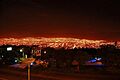
Tuxtla Gutiérrez at night
-
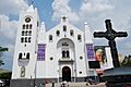
San Marcos Cathedral
-
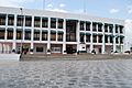
Tuxtla Gutiérrez Municipal Hall
-
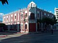
Tuxtla Gutiérrez City Museum
-
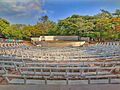
Bonampak Theatre
See also
 In Spanish: Tuxtla Gutiérrez para niños
