
Grand Canyon facts for kids
Quick facts for kids Grand Canyon |
|
|---|---|
.jpeg)
The Colorado River flowing through the Grand Canyon in Arizona
|
|
| Floor elevation | Approx. 2,600 ft (800 m) |
| Length | 277 mi (446 km) |
| Width | 4 to 18 mi (6.4 to 29.0 km) |
| Geology | |
| Age | 5–6 million years |
| Geography | |
| Location | Arizona |
| Country | United States |
| Rivers | Colorado River |
The Grand Canyon is a huge, steep-sided canyon in Arizona, United States. The mighty Colorado River carved this amazing natural wonder. It stretches about 277 miles (446 km) long. At its widest, it is up to 18 miles (29 km) across. The canyon is also incredibly deep, reaching over a mile (1,857 meters) down.
This famous canyon and its edges are part of several protected areas. These include Grand Canyon National Park and lands belonging to Native American tribes. President Theodore Roosevelt loved the Grand Canyon. He worked hard to protect it for everyone to enjoy.
The Grand Canyon shows nearly two billion years of Earth's history. The Colorado River and its smaller streams slowly cut through many layers of rock. This happened as the Colorado Plateau land slowly rose up. Scientists believe the Colorado River started carving its path here about 5 to 6 million years ago. Over time, the river kept digging deeper and wider, creating the canyon we see today.
Native American people have lived in the Grand Canyon area for thousands of years. They built homes inside the canyon and its many caves. The Pueblo people saw the Grand Canyon as a sacred place. They often made special journeys there. The first European to see the Grand Canyon was García López de Cárdenas from Spain in 1540.
Contents
- Exploring the Grand Canyon's Landscape
- How the Grand Canyon Formed: A Look at Geology
- Water in the Canyon: Hydrology
- A Journey Through Time: Grand Canyon History
- Grand Canyon Weather and Climate
- Climate Change and the Grand Canyon
- Grand Canyon's Amazing Wildlife and Plants
- Visiting the Grand Canyon: Tourism and Activities
- Staying Safe at the Grand Canyon
- Interesting facts about the Grand Canyon
- See also
Exploring the Grand Canyon's Landscape


The Grand Canyon is a huge river valley located on the Colorado Plateau. It shows off very old rock layers that have been pushed upwards. While it's not the deepest canyon in the world, it is famous for its amazing size and colorful views. These ancient rock layers tell us a lot about the early history of North America.
Over millions of years, the land rose, forming the Colorado Plateau. This higher land gets more rain and snow, but the Grand Canyon area is still quite dry. The land doesn't rise evenly. The North Rim of the canyon is about 1,000 feet (305 meters) higher than the South Rim. Because of this, the North Rim gets more rain and snow. Its streams flow into the Grand Canyon, creating longer side canyons. The South Rim's streams often flow away from the canyon, making its side canyons shorter and steeper.
The North Rim is higher, so it's usually cooler than the South Rim. It averages about 8,000 feet (2,438 meters) above sea level. Both rims can get heavy rains in the summer. During winter, the main road to the North Rim (State Route 67) often closes due to snow.
How the Grand Canyon Formed: A Look at Geology


The Grand Canyon is part of the Colorado River basin. This area has been changing for about 70 million years. Scientists have studied the canyon for over 150 years. They have many ideas about how the Grand Canyon and the Colorado River were formed. It's a complex story with many natural processes working together.
Today, many scientists agree that the canyon formed in different sections. These sections were carved at different times and later connected. The central parts might be 15 to 70 million years old. The ends of the canyon, like Marble Canyon, were carved more recently, in the last 5 to 6 million years.
The rocks you see in the Grand Canyon are incredibly old. At the very bottom, there's the Vishnu Schist, which is about two billion years old. At the top, on the rim, is the Kaibab Limestone, about 270 million years old. There's a huge time gap in between, called the Great Unconformity. This means some rock layers from a long period are missing.
Later, between 1.25 billion and 730 million years ago, layers of sand and mud started to build up. Many of these layers formed in warm, shallow seas, on beaches, or in swamps. The sea level kept changing, covering and uncovering the land. For example, the Coconino Sandstone formed from ancient sand dunes.
The Colorado Plateau, where the canyon sits, rose thousands of feet starting about 65 million years ago. This made the Colorado River flow faster and cut through the rock more quickly. During past ice ages, there was also more water in the river system. This helped the river carve its channel even faster and deeper.
About 5.3 million years ago, the Gulf of California opened up. This lowered the river's "base level" (its lowest point). This change made the river erode the land even faster. Most of the canyon's current depth was carved by 1.2 million years ago. The step-like walls of the canyon were created because different rocks erode at different speeds.
Between 100,000 and 3 million years ago, volcanic activity happened in the area. Lava and ash sometimes blocked the river completely. These volcanic rocks are the newest ones found in the canyon.
Water in the Canyon: Hydrology
.jpg)
Water that soaks into the ground from rain and snow is called groundwater. It collects in underground layers of rock called aquifers. Some rock layers are like sponges, letting water flow through easily. Others are like barriers, blocking the water.
The Grand Canyon has two main aquifers where groundwater collects. The upper C-aquifer gathers water that seeps through the top rock layers. Below it, the R-aquifer, also known as the Red Wall Muav aquifer, holds water in fractured rock. Water from these aquifers can flow sideways and appear as springs and seeps along the canyon walls.
Scientists study the water in these springs. They found that some water is quite new, from recent rains. Other water is very old, sometimes thousands of years old! This helps them understand how water moves through the canyon.
It's important to protect these underground water sources. Some areas of the plateau are more vulnerable to pollution reaching the aquifers. This is why careful management of the land is so important.
A Journey Through Time: Grand Canyon History

Native American Heritage
The Ancestral Puebloans were the first known people to live in the Grand Canyon area. Their culture was centered in the Four Corners region of the United States. They built settlements within the canyon and its many caves. The term "Anasazi" was often used for them, but modern Pueblo people prefer other names.
Archaeologists believe this culture began around 1200 BCE. They are thought to be the ancestors of today's Pueblo people. Other cultures also lived near the Grand Canyon. The Cohonina lived to the west between 500 and 1200 CE. They are ancestors of the Yuman, Havasupai, and Hualapai peoples. The Sinagua lived southeast of the canyon between 500 and 1425 CE. They may be ancestors of some Hopi clans.
By the 1500s, new cultures had developed. The Hualapai live along a 100-mile stretch of the canyon's southern side. The Havasupai have lived near Cataract Canyon since the 1200s. The Southern Paiutes live in parts of Utah and Arizona. The Navajo, or Diné, live in a wide area stretching east from the San Francisco Peaks. Their ancestors migrated from Canada after the 1000s. Some Hopi mythology says the Grand Canyon is where humankind first emerged.
European Explorers and Settlers
Early Spanish Expeditions

In September 1540, Spanish explorer García López de Cárdenas became the first European to see the Grand Canyon. He was searching for the fabled Seven Cities of Cibola. With Hopi guides, he reached the South Rim. Some of his soldiers tried to climb down but had to return due to lack of water. They reported that some rocks were "bigger than the great tower of Seville." It is thought that the Hopi guides knew paths to the river but did not lead the Spanish there. No other Europeans visited for over 200 years.
In 1776, two Spanish priests, Fathers Francisco Atanasio Domínguez and Silvestre Vélez de Escalante, explored the North Rim. They were looking for a route from Santa Fe to California. They found a crossing, now under Lake Powell. Also in 1776, Franciscan missionary Fray Francisco Garces spent a week near Havasupai. He described the canyon as "profound."
American Exploration and Mapping
In 1826, James Ohio Pattie, an American trapper, may have been the next European to reach the canyon. Jacob Hamblin, a Mormon missionary, explored the canyon in the 1850s. He found river crossing sites and built good relationships with local Native Americans. He also advised John Wesley Powell on his expeditions.
In 1857, Edward Fitzgerald Beale's expedition surveyed a wagon road. May Humphreys Stacey, a member of the group, described seeing "a wonderful canyon; four thousand feet deep." That same year, Lieutenant Joseph Ives led a U.S. War Department expedition. He explored the Colorado River by steamboat and rowboat. Ives's report in 1861 confirmed the canyon's amazing size.
John Strong Newberry became the first geologist to visit the Grand Canyon in 1858.
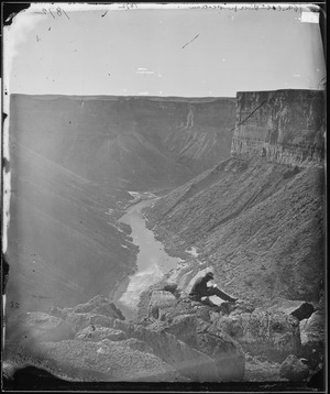
Powell's Famous Expeditions

In 1869, Major John Wesley Powell led the first expedition down the Colorado River and through the Grand Canyon. He and nine men set out from Green River, Wyoming. They faced dangerous rapids and lost one boat and much of their food. Three men left the expedition, fearing the rapids ahead. Sadly, they were later killed. The remaining members safely passed through the rapids.
Powell later became the first to use the name "Grand Canyon" in 1871. Before that, it was called the "Big Canyon." He also became a director of important U.S. scientific agencies.
In 1889, Frank M. Brown tried to explore the canyon to build a railroad. He drowned in an accident. His chief engineer, Robert Brewster Stanton, continued the exploration.
Protecting the Grand Canyon
.jpg)

.jpg)
President Theodore Roosevelt visited the Grand Canyon in 1903. He loved the outdoors and worked to protect nature. In 1906, he created the Grand Canyon Game Preserve. He also used the Antiquities Act of 1906 to make it a U.S. National Monument in 1908.
It took 11 more years for the Grand Canyon to become a U.S. National Park. President Woodrow Wilson signed the law on February 26, 1919. Today, park managers work to protect the canyon's wildlife and natural beauty.
The construction of the Glen Canyon Dam in 1963 changed the canyon's ecosystem. Natural floods became much smaller. This caused sandbars to erode and allowed non-native plants to grow. Since 1996, federal officials have released controlled floods to try and restore the ecosystem. However, due to extreme drought, water levels in Lake Powell have dropped significantly. This has affected planned water releases from the dam.
Grand Canyon Weather and Climate

Weather in the Grand Canyon changes a lot with elevation. The forested rims get winter snow. But along the Colorado River at the bottom, temperatures are like those in Arizona's deserts. The region is generally dry. However, it gets significant rain twice a year. Winter brings widespread rain and snow from Pacific storms. Late summer brings dramatic thunderstorms from the North American Monsoon.
The South Rim gets less than 16 inches (41 cm) of rain and about 60 inches (152 cm) of snow each year. The higher North Rim gets more moisture, about 27 inches (69 cm) of rain and 144 inches (366 cm) of snow. Phantom Ranch, deep in the canyon, gets only about 8 inches (203 mm) of rain, and snow is rare.
Temperatures vary greatly. Summer highs in the Inner Gorge often go over 100°F (38°C). Winter lows on the rims can drop below 0°F (-18°C). Visitors should be prepared for these extreme conditions. Dehydration, sunburn, and hypothermia are possible risks. Always check accurate weather forecasts before hiking.
Air Quality in the Canyon

The Grand Canyon area generally has very clean air. However, pollution from power plants, mining, and cities can affect it. Forest fires and dust storms also impact air quality. Visibility is usually best in winter. Cold fronts bring clean air. In summer, winds carry pollution from urban areas, reducing visibility.
Sulfates, soil, and organic particles are the main pollutants. Sulfates come from cities and copper smelters. Soil particles come from windy conditions and road dust. Organic particles come from vehicles, cities, and forest fires.
Many actions have been taken to improve air quality. The Clean Air Act helped create groups to protect visibility. The Regional Haze Rule aims to restore natural visibility by 2064. Power plants near the canyon have reduced their emissions. For example, the Navajo Generating Station closed in 2019, eliminating its emissions.
Prescribed fires are used in nearby forests. These fires reduce the risk of large wildfires. While they create some smoke, they are managed to minimize their impact on air quality.
Climate Change and the Grand Canyon

Temperatures in Arizona have risen by 2.1 degrees Fahrenheit since 1895. This is due to an increase in greenhouse gases. From 1916 to 2014, water flow in the Upper Colorado River Basin decreased by 16.5%. This happened even with a slight increase in rainfall. Higher temperatures lead to more evaporation and less snowpack. This reduces the amount of water in the Colorado River.
The South Rim averages 13.4 inches (34 cm) of rain per year. The North Rim averages 24 inches (61 cm). Water for human use on the South Rim comes from underground springs on the North Rim. It is pumped through a 16-mile (26 km) pipeline.
As more visitors come to the park, water use increases. This puts a strain on the water supply and the aging pipeline. Plans to replace the pipeline have been proposed. Another idea is to drill a new well. However, the underground water sources are also affected by climate change. Over-pumping aquifers can lead to land sinking and less water in rivers.
The National Park Service has a "Climate Action Plan." It aims to reduce greenhouse gases and help the park adapt to climate change. This includes reducing emissions, educating visitors, and monitoring progress.
Grand Canyon's Amazing Wildlife and Plants
Plants and Their Habitats
There are about 1,737 types of vascular plants in Grand Canyon National Park. You can also find many kinds of fungi, moss, and lichen. This huge variety is because of the 8,000-foot (2,438-meter) change in elevation from the river to the North Rim. The Grand Canyon has a dozen plants found nowhere else in the world.
The western canyon has plants from the Mojave Desert. The eastern parts have plants from the Sonoran Desert. On both rims, you'll find ponderosa and pinyon pine forests. Natural springs and seeps on the canyon walls are home to 11% of all plant species.
The direction a slope faces also matters. North-facing slopes get less sunlight. Plants there are like those found in cooler, higher places. South-facing slopes get full sun. They have plants typical of the hot Sonoran Desert.
Animals and Their Life Zones

The park has many different ecosystems. It has five of North America's seven life zones. This is like traveling from Mexico to Canada! Differences in elevation and climate create these zones. The park has 129 plant communities.
Lower Sonoran Life Zone
This zone goes from the Colorado River up to 3,500 feet (1,067 meters). Along the river, you'll find plants like coyote willow, arrowweed, and mesquite. Rare plants grow in hanging gardens and springs. Endangered fish like the humpback chub live in the river.

Common amphibians here include the canyon tree frog and red-spotted toad. Many insects, spiders, and scorpions also live near the river. Forty-eight bird species nest along the river. The bald eagle uses the river in winter.
Mammals like coyotes, ringtails, and spotted skunks hunt for food. Beavers eat willows and cottonwoods. Bighorn sheep and mule deer also visit the river corridor.
Above the river, a desert scrub community thrives. It has plants like creosote bush, white bursage, and various cacti. Fifty mammal species, mostly rodents and bats, live here. The desert gopher tortoise, a threatened species, lives in the western part of the park.
Upper Sonoran and Transition Life Zones

This zone covers most of the inner canyon and South Rim, from 3,500 to 7,000 feet (1,067 to 2,134 meters). It has blackbrush, sagebrush, and pinyon-juniper woodlands. Plants like Utah agave and yucca grow here.
About 30 bird species breed in the inner canyon's uplands and cliffs. Peregrine falcons hunt here. Critically endangered California condors have been reintroduced to the area.


Conifer forests provide homes for 52 mammal species. Porcupines, red squirrels, tassel-eared squirrels, black bears, mule deer, and elk live at higher elevations.
Ponderosa pine forests grow between 6,500 and 8,200 feet (1,981 and 2,500 meters). You can find Gambel oak, mountain mahogany, and various grasses here. The Utah tiger salamander and Great Basin spadefoot toad are common amphibians. Many bird species breed in these forests.
Canadian and Hudsonian Life Zones
These zones are found at elevations from 8,200 to 9,000 feet (2,500 to 2,743 meters) on the North Rim. Spruce-fir forests grow here, with trees like Engelmann spruce, Douglas fir, and aspen. You'll also find grasses and wildflowers. Mountain lions, Kaibab squirrels, and American goshawks live in this sub-alpine climate.
Montane meadows and subalpine grasslands are rare and only on the North Rim. They are filled with many types of grasses and other small plants.

Visiting the Grand Canyon: Tourism and Activities
Grand Canyon National Park is a world-famous natural attraction. It welcomes about five million visitors each year. Most visitors are from the United States, but many come from other countries like the United Kingdom, Canada, and Japan.
The South Rim is open all year, weather permitting. The North Rim is usually open from mid-May to mid-October.
Fun Things to Do at the Grand Canyon


There are many amazing viewpoints around the canyon. The easiest places to visit are inside Grand Canyon National Park and on the Hualapai Indian Reservation. About 90% of tourists visit the South Rim, which is about 7,000 feet (2,134 meters) above sea level. The South Rim has visitor centers, a museum, and shops near Grand Canyon Village. Further east is the Desert View Watchtower.
The North Rim also has a visitor center, but it closes in winter. On the Hualapai reservation, Grand Canyon West is another popular spot. It's about 125 miles (201 km) from Las Vegas. Here, you can walk on the glass-bottomed Grand Canyon Skywalk. Guano Point offers stunning views from a narrow cliff. The Grand Canyon–Parashant National Monument on the north side has no paved roads or visitor services.
Other popular activities include rafting, hiking, and helicopter tours. You can reach the bottom of the canyon by foot, mule, or boat. Park officials advise against hiking down to the river and back up in one day. The trails are steep, rocky, and temperatures at the bottom are much hotter. Many people need rescue each year because of heat exhaustion. However, many fit hikers complete the trip safely.
Camping on the North and South rims is usually in campgrounds. Reservations are highly recommended, especially for the busy South Rim. Camping below the rim requires a special permit. Each year, many people apply for these permits.
For a bird's-eye view, you can take helicopter or small airplane tours. These flights offer incredible views of the canyon. Some helicopter flights even land on the Havasupai and Hualapai Indian Reservations. In 2016, skydiving became an option at the Grand Canyon National Park Airport.
In 2014, there were plans for a large complex called the Grand Canyon Escalade on the rim. It would have included shops, hotels, and a gondola to the canyon floor. However, the Navajo Nation Council voted against the project in 2017.
Staying Safe at the Grand Canyon

Between the mid-1800s and 2015, about 770 deaths occurred in the Grand Canyon. Many of these were due to accidents. The most common causes included airplane and helicopter crashes, falls, and environmental factors like heat stroke or dehydration. Drowning in the Colorado River and flash floods also caused some deaths. Most accidents can be prevented by following safety guidelines.
In 1956, two commercial planes collided above the canyon. This tragic accident led to the deaths of all 128 people on board. This event highlighted the need for better air traffic control.

Interesting facts about the Grand Canyon
- The Grand Canyon is one of the most popular natural attractions in the world. About five million people visit every year.
- President Theodore Roosevelt loved the area. He made the canyon a National Monument in 1908. It officially became a National Park in 1919.
- The rock layers in the canyon walls reveal nearly two billion years of Earth's history.
- For a long time, many scientists thought the canyon was 5 to 6 million years old. However, newer studies have suggested that parts of the canyon might be much older. For example, some research on caves near the canyon suggests they formed about 17 million years ago. Other studies looked at minerals and hinted that parts of the canyon were deep around 20 million years ago. Some even think the western part could be as old as 70 million years!
- The first European to see the canyon was García López de Cárdenas from Spain, who arrived in 1540.
- The Pueblo people consider the Grand Canyon a holy place.
See also
 In Spanish: Gran Cañón para niños
- A Bigger Grand Canyon, 1998 painting
- Copper Canyon, Mexico
- Grand Canyon National Park
- Grand Canyon Suite
- Jacob Lake, Arizona
- List of Colorado River rapids and features
- List of trails in Grand Canyon National Park
- Making North America (2015 PBS film)
- Pine Creek Gorge – Gorge in northeastern Pennsylvania also known as the "Pennsylvania Grand Canyon"
- Providence Canyon – Canyon in southwestern Georgia also known as Georgia's "Little Grand Canyon"
- Valles Marineris – A gigantic canyon on Mars, one of the largest in the Solar System
- Verdon Gorge, France
