
O'Neill Butte facts for kids
Quick facts for kids O'Neill Butte |
|
|---|---|

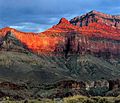
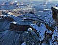
South aspect, from Cedar Ridge
|
|
| Highest point | |
| Elevation | 6,071 ft (1,850 m) |
| Prominence | 311 ft (95 m) |
| Isolation | 4.17 mi (6.71 km) |
| Parent peak | Zoroaster Temple (7,123 ft) |
| Geography | |

O'Neill Butte
Location in Arizona

O'Neill Butte
Location in the United States
|
|
| Location | Grand Canyon National Park Coconino County, Arizona, US |
| Parent range | Coconino Plateau Colorado Plateau |
| Topo map | USGS Phantom Ranch |
| Type of rock | limestone, shale, sandstone |
| Climbing | |
| Easiest route | class 5.0 to 5.9 routes |
O'Neill Butte is a mountain peak in the amazing Grand Canyon in Arizona, United States. It stands tall at 6,071-foot (1,850 m) (about 1,850 meters) above sea level. This butte is located in Coconino County. It is about 2.5 miles (4.0 km) (4 kilometers) east of Grand Canyon Village. You can see it northeast of Mather Point and northwest of Yaki Point.
O'Neill Butte rises a huge 3,600 feet (1,100 m) (1,097 meters) above the Colorado River in just two miles (3.2 km) (3.2 kilometers). This shows how steep the land is! A path called the South Kaibab Trail goes along the east side of the peak. The area around O'Neill Butte has a cold semi-arid climate. This means it's usually dry and can get quite cold.
The Story Behind O'Neill Butte's Name
O'Neill Butte is named after a brave man named William Owen "Buckey" O'Neill. He was born in 1860 and passed away in 1898. Buckey O'Neill was an important person in the Arizona Territory government. He was also a captain in Theodore Roosevelt's famous group of soldiers called the Rough Riders. He died fighting in the Battle of San Juan Hill.
Before that, in 1890, Buckey O'Neill explored the Grand Canyon, looking for valuable minerals. He also played a big part in bringing the railroad to the South Rim of the canyon. This made it much easier for people to visit this natural wonder. The name "O'Neill Butte" was officially chosen in 1906 by the U.S. Board on Geographic Names.

Understanding O'Neill Butte's Geology
The top part of O'Neill Butte is made of a type of rock called Esplanade Sandstone. This sandstone formed during the Permian period, which was a very long time ago. Below this sandstone, you can find other layers of rock.
These layers include the Supai Group, which has more sandstone and shale. Below the Supai Group is the Redwall Limestone, a thick layer of limestone that often forms steep cliffs. Even further down, you'll find the Tonto Group, which formed during the Cambrian period. At the very bottom, near the Colorado River, are the Vishnu Basement Rocks. These are some of the oldest rocks on Earth, formed during the Paleoproterozoic era.
When it rains on O'Neill Butte, the water flows down into the Colorado River. The water on the west side of the butte goes into Pipe Creek, and water on the east side flows into Cremation Creek.
Gallery
-
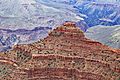
O'Neill Butte in the center, with Yaki Point on the upper right. This view is from the northwest.
-
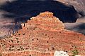
O'Neill Butte as seen from Yavapai Point.
-
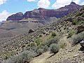
The west side of O'Neill Butte (upper right) from the Tonto Trail.
-
-
O'Neill Butte covered in snow, seen from Mather Point during winter.


.jpg)
.jpg)

