Williams, Arizona facts for kids
Quick facts for kids
City of Williams
|
|
|---|---|
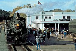
Steam locomotive 29 and train sitting at Williams Depot, 1993
|
|
| Nickname(s):
Gateway to the Grand Canyon
|
|
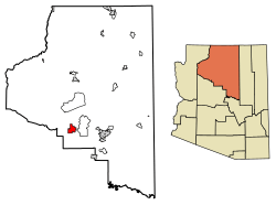
Location of Williams in Coconino County, Arizona
|
|
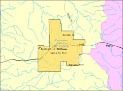
U.S. Census Map
|
|
| Country | United States |
| State | Arizona |
| County | Coconino |
| Settled | 1881 |
| Incorporated | July 9, 1901 |
| Government | |
| • Type | Council-Manager |
| Area | |
| • Total | 44.17 sq mi (114.41 km2) |
| • Land | 43.83 sq mi (113.52 km2) |
| • Water | 0.34 sq mi (0.89 km2) |
| Elevation | 6,916 ft (2,108 m) |
| Population
(2020)
|
|
| • Total | 3,202 |
| • Density | 73.06/sq mi (28.21/km2) |
| Time zone | UTC−7 (MST) |
| ZIP code |
86046
|
| Area code | 928 |
| FIPS code | 04-83160 |
| GNIS feature ID | 2412267 |
| Website | City of Williams |
Williams (which is called Wii Gvʼul in the Havasupai language) is a city in Coconino County, Arizona, United States. It is located west of Flagstaff. In 2020, about 3,202 people lived there.
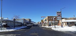
Williams is found along the famous Historic Route 66 and Interstate 40. It is also the starting point for the Grand Canyon Railway. This special train takes visitors right to Grand Canyon Village.
People often call Williams the "Gateway to the Grand Canyon." It was the very last city on Historic Route 66 to be bypassed by the new Interstate 40 highway. The city's old downtown area covers six city blocks.
Contents
History of Williams
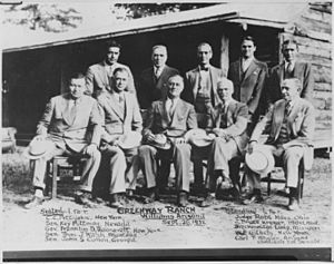
Williams was founded in 1881. It was named after a famous person called William Sherley "Old Bill" Williams. He was a trapper, trader, scout, and mountain man who often worked in this area. You can see a statue of "Old Bill" in Monument Park, on the west side of the city. A large mountain to the south is also named after him: Bill Williams Mountain. The city officially became a town on July 9, 1901.
Williams was the last city where a part of Route 66 was bypassed by a new highway. This happened because of lawsuits that stopped the last part of Interstate 40 in Arizona from being built around the city. After agreements were made for the state to build three exits for Williams, the lawsuits stopped. Interstate 40 was finished on October 13, 1984. Newspapers the next day said this was basically the end of US 66. The next year, Route 66 was officially taken out of service.
The Williams Historic Business District and Urban Route 66, Williams are important places. They were added to the National Register of Historic Places in 1984 and 1989. This means they are recognized as important historical sites.
What is the Population of Williams?
| Historical population | |||
|---|---|---|---|
| Census | Pop. | %± | |
| 1890 | 199 | — | |
| 1910 | 1,267 | — | |
| 1920 | 1,350 | 6.6% | |
| 1930 | 2,166 | 60.4% | |
| 1940 | 2,622 | 21.1% | |
| 1950 | 2,152 | −17.9% | |
| 1960 | 3,559 | 65.4% | |
| 1970 | 2,386 | −33.0% | |
| 1980 | 2,266 | −5.0% | |
| 1990 | 2,532 | 11.7% | |
| 2000 | 2,842 | 12.2% | |
| 2010 | 3,023 | 6.4% | |
| 2020 | 3,202 | 5.9% | |
| U.S. Decennial Census | |||
In 2020, the city of Williams had 3,202 people living there. The population has grown over the years. In 2000, there were 2,842 people.
About 36% of homes in Williams had children under 18 living there in 2000. The average age of people in the city was 35 years old.
Geography and Climate
Bill Williams Mountain is a tall mountain located just south of Williams. It rises to about 9,256 feet (2,821 meters) high. The city of Williams covers a total area of about 43.8 square miles (113.4 square kilometers). Most of this area is land.
What is the Weather Like in Williams?
The weather in Williams is unique for Arizona. It has an oceanic climate, which means it has mild temperatures.
December is usually the coldest month, and July is the warmest. August is the month with the most rain. The highest temperature ever recorded in Williams was 102°F (39°C) in 1909. The coldest temperature was -25°F (-32°C) in 1937.
| Climate data for Williams, Arizona (1991–2020 normals, extremes 1897–present) | |||||||||||||
|---|---|---|---|---|---|---|---|---|---|---|---|---|---|
| Month | Jan | Feb | Mar | Apr | May | Jun | Jul | Aug | Sep | Oct | Nov | Dec | Year |
| Record high °F (°C) | 74 (23) |
74 (23) |
76 (24) |
87 (31) |
92 (33) |
100 (38) |
102 (39) |
101 (38) |
93 (34) |
86 (30) |
80 (27) |
74 (23) |
102 (39) |
| Mean maximum °F (°C) | 58.6 (14.8) |
60.6 (15.9) |
66.7 (19.3) |
73.9 (23.3) |
81.7 (27.6) |
90.0 (32.2) |
92.1 (33.4) |
88.7 (31.5) |
83.9 (28.8) |
77.4 (25.2) |
68.1 (20.1) |
60.2 (15.7) |
93.0 (33.9) |
| Mean daily maximum °F (°C) | 47.2 (8.4) |
49.2 (9.6) |
55.6 (13.1) |
62.3 (16.8) |
71.2 (21.8) |
81.8 (27.7) |
84.1 (28.9) |
81.5 (27.5) |
76.4 (24.7) |
66.7 (19.3) |
55.7 (13.2) |
47.0 (8.3) |
64.9 (18.3) |
| Daily mean °F (°C) | 34.3 (1.3) |
35.9 (2.2) |
41.2 (5.1) |
46.8 (8.2) |
55.1 (12.8) |
64.9 (18.3) |
68.8 (20.4) |
66.9 (19.4) |
61.5 (16.4) |
51.3 (10.7) |
41.7 (5.4) |
33.9 (1.1) |
50.2 (10.1) |
| Mean daily minimum °F (°C) | 21.4 (−5.9) |
22.7 (−5.2) |
26.8 (−2.9) |
31.3 (−0.4) |
39.1 (3.9) |
47.9 (8.8) |
53.6 (12.0) |
52.3 (11.3) |
46.6 (8.1) |
36.0 (2.2) |
27.6 (−2.4) |
20.8 (−6.2) |
35.5 (1.9) |
| Mean minimum °F (°C) | 7.4 (−13.7) |
8.5 (−13.1) |
14.0 (−10.0) |
20.7 (−6.3) |
27.7 (−2.4) |
36.4 (2.4) |
47.7 (8.7) |
47.0 (8.3) |
36.6 (2.6) |
23.3 (−4.8) |
13.6 (−10.2) |
6.6 (−14.1) |
2.6 (−16.3) |
| Record low °F (°C) | −25 (−32) |
−18 (−28) |
−6 (−21) |
2 (−17) |
8 (−13) |
22 (−6) |
32 (0) |
32 (0) |
11 (−12) |
7 (−14) |
−7 (−22) |
−17 (−27) |
−25 (−32) |
| Average precipitation inches (mm) | 2.17 (55) |
2.61 (66) |
2.00 (51) |
0.87 (22) |
0.76 (19) |
0.38 (9.7) |
2.98 (76) |
3.38 (86) |
1.59 (40) |
1.59 (40) |
1.34 (34) |
1.94 (49) |
21.61 (549) |
| Average snowfall inches (cm) | 16.8 (43) |
12.4 (31) |
11.1 (28) |
5.7 (14) |
0.1 (0.25) |
0.0 (0.0) |
0.0 (0.0) |
0.0 (0.0) |
0.0 (0.0) |
0.7 (1.8) |
4.8 (12) |
13.5 (34) |
65.1 (165) |
| Average extreme snow depth inches (cm) | 7 (18) |
6 (15) |
5 (13) |
2 (5.1) |
0 (0) |
0 (0) |
0 (0) |
0 (0) |
0 (0) |
0 (0) |
2 (5.1) |
5 (13) |
7 (18) |
| Average precipitation days (≥ 0.01 inch) | 6.6 | 6.4 | 5.9 | 3.7 | 4.1 | 2.5 | 10.8 | 12.6 | 6.5 | 4.4 | 3.9 | 5.8 | 73.2 |
| Average snowy days (≥ 0.1 inch) | 3.8 | 3.9 | 2.9 | 1.6 | 0.1 | 0.0 | 0.0 | 0.0 | 0.0 | 0.2 | 1.7 | 3.3 | 17.5 |
| Source: NOAA | |||||||||||||
Education in Williams
The Williams Unified School District serves the city of Williams. There are two main schools: Williams Elementary Middle School and Williams High School. These schools serve students from elementary grades through high school. There is also a charter school called Heritage Elementary Charter School.
Parks and Recreation
The city of Williams has many parks and public places for fun activities. The Parks and Recreation Department manages these areas.
Fun Places to Visit
- Recreation Center & Skate Park: This place is great for young people. It has an indoor skate park called the "Shed."
- Williams Aquatic Center: This is an indoor swimming pool. It's open during the warmer months for swimming and fun.
- Cureton Park: Here you can play softball, baseball, and basketball. It also has picnic areas and restrooms.
- Buckskinner Park: This park has basketball and volleyball courts. It also has a lake where you can fish, which is regularly stocked with fish. There are also trails for hiking.
- Cataract Lake County Park: This park is a joint effort between Coconino County and the City of Williams. It has barbecue pits, a playground, and restrooms. The lake is also stocked for fishing.
- Dogtown Reservoir: This reservoir and its recreation areas are close by.
- Rodeo Facility: The city also has a place for rodeos. It hosts the yearly Williams Reunion Rodeo.
Transportation in Williams
For many years, the Amtrak Southwest Chief train stopped near Williams. Passengers would take a shuttle from the station to downtown Williams. In 2018, the train stop closed. Now, Amtrak offers a bus service between Williams and Flagstaff.
The old train station in downtown Williams is still used. It is the southern starting point for the Grand Canyon Railway. Williams also has a small airport for private planes called the H.A. Clark Memorial Field.
Arts and Culture
Williams has many arts and cultural events throughout the year.
Popular Events and Activities
- The Polar Express: From December to January, the Grand Canyon Railway runs a special train ride. It's based on the popular children's book The Polar Express by Chris Van Allsburg.
- Historic Route 66 Car Show: This show features classic cars from the time when Route 66 was very busy.
- Cataract Creek Gang: During the summer, this group of Old West characters puts on a gun fight show every night in the streets of Williams. They also sometimes "rob" the Grand Canyon Railway train when it returns from the Grand Canyon!
Films Made in Williams
Some Hollywood movies with famous actors have been filmed in and around Williams.
- Guns of the Timberland (1960), starring Alan Ladd
- Midnight Run (1988), starring Robert De Niro
- Speechless (1994), starring Michael Keaton
Tourism in Williams
Tourism is very important to Williams' economy. Williams is about a one-hour drive (60 miles) from the South Entrance of the Grand Canyon. It's also about 42 miles west of Flagstaff, connected by Interstate 40.
Top Tourist Attractions
- Bearizona Wildlife Park: A drive-through wildlife park.
- Grand Canyon Railway & Hotel: Offers train rides to the Grand Canyon.
- Grand Canyon Deer Farm: A place where you can see and feed deer.
- Canyon Coaster Adventure Park: An adventure park with a mountain coaster.
- Pete's Route 66 Gas Station Museum: A museum about the history of Route 66.
- Planes of Fame Air Museum: A museum with many historic airplanes.
Famous People From Williams
- Hap Collard, a baseball pitcher.
- Diana Gabaldon, a writer known for the Outlander novels and TV series.
- Ross Hagen, an actor and director.
- Billy Hatcher, a baseball player and coach.
- Tom Ray, an animator for Warner Brothers cartoons.
- Old Bill Williams, the famous mountain man the town is named after.
See also
 In Spanish: Williams (Arizona) para niños
 | Frances Mary Albrier |
 | Whitney Young |
 | Muhammad Ali |


