
Arizona State Route 67 facts for kids
Quick facts for kids
|
||||
|---|---|---|---|---|
| Kaibab Plateau – North Rim Parkway | ||||
|
SR 67 highlighted in red
|
||||
| Route information | ||||
| Maintained by ADOT and NPS | ||||
| Length | 43.4 mi (69.8 km) | |||
| Existed | 1941–present | |||
| Tourist routes |
||||
| Restrictions | Closed winters | |||
| Major junctions | ||||
| South end | Bright Angel Point south of North Rim | |||
| North end | ||||
| Highway system | ||||
| State routes in Arizona Unconstructed • Former
|
||||

State Route 67 (SR 67) is a road in northern Arizona that is about 43.4 miles (70 km) long. It runs from north to south. This road is also known as the Kaibab Plateau – North Rim Parkway. It is the only road that connects U.S. Route 89A (US 89A) at Jacob Lake to the North Rim of Grand Canyon National Park.
As you drive along SR 67, you will pass through the national park and the Kaibab National Forest. The road is surrounded by tall evergreen trees. The part of the road inside the national park is taken care of by the National Park Service (NPS). The part north of the park entrance, which is in the Kaibab National Forest, is managed by the Arizona Department of Transportation (ADOT).
This road was first built in the late 1920s. It was improved a lot during the 1930s. In 1941, the road was officially given its number, SR 67. Later, in the 1980s, it was named the Kaibab Plateau – North Rim Parkway. This parkway has been recognized as both a National Forest Scenic Byway and a National Scenic Byway because of its beautiful views.
Contents
What is State Route 67 Like?
The signs for SR 67 start at Bright Angel Point. This point is located along the North Rim of the Grand Canyon National Park. Even though the ADOT does not officially own this part of the road, it is still marked as SR 67.
Journey Through the Kaibab Plateau
The road heads north as the Kaibab Plateau – North Rim Parkway. It goes through the small community of North Rim. Here, you'll see many evergreen trees all around you. The parkway then enters a small open area. After this, you reach the park entrance. This is where ADOT officially takes over the road's care.
As the road continues north, it enters the Kaibab National Forest. It is surrounded by a narrow grassy area with more evergreen trees. SR 67 passes by Deer Lake. Here, it meets an unpaved National Forest road. Many other unpaved roads crisscross the area around SR 67. The highway makes several turns but generally keeps heading north.
Grand Canyon Highway and Scenic Views
The road is also sometimes called the Grand Canyon Highway. It continues north through the woods, making more turns. It then takes a path that goes more towards the northwest. This part of the road is in Coconino County. Near its end, the road turns back towards the northeast. It finally finishes at US 89A in Jacob Lake.

Road Maintenance and Traffic
The northern part of SR 67 is maintained by ADOT. They are in charge of keeping SR 67 in good condition, just like all other highways in Arizona. To do this, ADOT regularly checks how many vehicles use their roads. They often report this as the average annual daily traffic. This is the average number of vehicles that use the road each day during the year.
In 2009, ADOT found that about 1,100 vehicles used the northern end of SR 67 near Jacob Lake every day. The Federal Highway Administration (FHWA) has listed SR 67 as a National Scenic Byway. The National Forest Service has also called it a National Forest Service Byway. These names show how beautiful and important the road is for tourism.
Winter Closures
SR 67 is not part of the National Highway System. This system includes roads that are very important for the country's economy, defense, and travel.
Because the Grand Canyon's North Rim facilities close for winter, SR 67 is usually closed to cars from December 1 until spring. This means no winter maintenance is done on the road after December 1.
History of State Route 67
SR 67 has been a way to reach the North Rim of the Grand Canyon National Park for a long time. As early as 1927, it existed as a dirt road.

Improvements Over Time
By 1935, the road had been improved. It was no longer just dirt but a gravel road. A few years later, by 1938, the road was paved. This made it much smoother and easier to drive on.
In 1941, the road was officially named a state highway. It was given the number SR 67. In 1985, the highway received a special name: the Kaibab Plateau – North Rim Parkway. This was part of Arizona's State Scenic Byway program. This special name included all of SR 67 and even extended south into Grand Canyon National Park.
National Recognition
Two years later, ADOT gained the right-of-way for the highway. This means they got the legal right to use the land for road improvements. This was for the northern 10 miles (16 km) of the highway. In 1989, ADOT got more right-of-way for about 5 miles (8 km) from the southern end.
By June 1989, the parkway was named a National Forest Scenic Byway. Then, in June 1998, the Kaibab Plateau – North Rim Parkway received another important title: a National Scenic Byway. Since it was first established, the road has stayed on its original path and has not been moved.
Road Connections
The entire route is in Coconino County.
| Location | Mile | Roads intersected | Notes | |
|---|---|---|---|---|
| Grand Canyon NP | 43.4 | Bright Angel Point | Southern end of the road | |
| 30.81 | 49.58 | North entrance station | Where ADOT starts owning the road | |
| Jacob Lake | 0.00 | 0.00 | Northern end of the road | |
| 1.000 mi = 1.609 km; 1.000 km = 0.621 mi | ||||
Images for kids
-
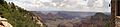
A beautiful view of the Grand Canyon from Grand Canyon Lodge near Bright Angel Point.
See also
 In Spanish: Ruta Estatal de Arizona 67 para niños
