
Hopi Reservation facts for kids
Quick facts for kids
Hopi Reservation
Hopituskwa (Hopi)
|
||
|---|---|---|
|
||

Location in Arizona
|
||
| Tribe | Hopi | |
| Country | United States | |
| State | Arizona | |
| Counties | Coconino Navajo |
|
| Established | December 16, 1882 | |
| Constitution | December 19, 1936 | |
| Capital | Kykotsmovi (de facto) | |
| Subdivisions | ||
| Government | ||
| • Body | Hopi Tribal Council | |
| Area | ||
| • Total | 6,557.262 km2 (2,531.773 sq mi) | |
| Population
(2017)
|
||
| • Total | 9,268 | |
| • Density | 1.41339/km2 (3.66068/sq mi) | |
| Time zone | Mountain: UTC −7 (no DST) | |
| Website | hopi-nsn.gov | |


The Hopi Reservation (in Hopi: Hopituskwa) is a special area of land set aside for the Hopi and Arizona Tewa people. It is located in northeastern Arizona, United States. This reservation is completely surrounded by the Navajo Nation.
The Hopi Reservation covers about 2,531 square miles (6,557 square kilometers). In 2000, about 6,946 people lived there. The Hopi and Navajo nations once shared some land. Later, a law in 1974 created a clear boundary between their lands.
The Hopi people live in villages built on three mesas. A mesa is a flat-topped hill with steep sides. This style of building villages is traditional for the Hopi. Walpi is the oldest village on the First Mesa. It was built around 1690 after people moved from lower areas. They moved to the mesa tops for safety after the 1680 Pueblo Revolt.
The Tewa people also live on the First Mesa. Hopi people live on the Second Mesa and Third Mesa as well. The community of Winslow West is also connected to the Hopi tribe.
The Hopi Tribal Council is the government for the reservation. It is made up of elected leaders from the different villages. Their powers come from the Hopi Tribal Constitution. The Hopi people believe their traditional way of life on the reservation is very important. This includes their clan system, spiritual life in the kivas, and growing corn.
Hopi High School provides education for students living on the reservation. Hopi Radio is a radio station that serves the reservation. It plays a mix of traditional Hopi music and American programming. It also offers training for students from Hopi High School.
Contents
Communities on the Hopi Reservation

The Hopi Reservation is home to several communities. These include:
- Keams Canyon
- Lower and Upper Moenkopi
- Polacca
- Winslow West
- Yuuwelo Paaki (also known as Spider Mound)
- New Oraibi (also called Kiqotsmovi or Kykotsmovi)
First Mesa Villages
The First Mesa has these villages:
- Waalpi (Walpi)
- Hanoki (also known as Hano or Tewa)
- Sitsomovi (Sichomovi)
Second Mesa Villages
The Second Mesa includes these villages:
- Songoopavi (Shongopavi)
- Musangnuvi (Mishongnovi)
- Sipawlavi (also known as Shipaulovi)
Third Mesa Villages
The Third Mesa is home to these communities:
Time Zone Information

The Hopi Reservation is in the Mountain Time Zone. This is the same time zone as most of Arizona. However, unlike the surrounding Navajo Nation, the Hopi Reservation does not use daylight saving time. This means their clocks do not change in the spring and fall.
Aerial Views of the Reservation
Here are some aerial views looking north. They show the central three of the reservation's five main washes, from west to east:
-
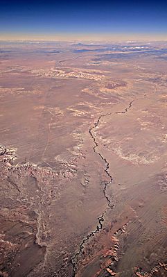
Dinnebito Wash, with Third Mesa in the distance
-
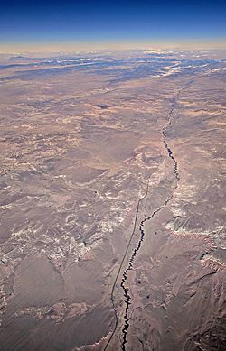
Oraibi Wash and Indian Route 2
-
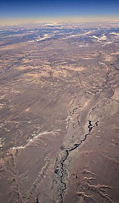
Polacca Wash, crossed by Arizona Route 87, with First Mesa and Second Mesa visible in the distance


