Wheeler Survey facts for kids
The Wheeler Survey, which happened between 1872 and 1879, was one of four big projects the U.S. government carried out after the Civil War. Its main goal was to explore and map the western parts of the United States. This survey helped document the land, its geology (how the Earth is made up), and its natural resources.
The survey was led by a military officer named First Lieutenant (who later became Captain) George Montague Wheeler. His team explored and mapped the area of the United States west of the 100th meridian. Another important member of the survey team was Lieutenant (who later became Brigadier General) Montgomery M. Macomb.

Contents
Exploring the American West
George Wheeler had already led some smaller expeditions in the West from 1869 to 1871. In 1872, the U.S. Congress approved a big plan to map the western part of the country. This large-scale mapping project became known as the Wheeler Survey.
What Was the Wheeler Survey?
The main purpose of the Wheeler Survey was to create detailed maps of the southwestern United States. These were called topographic maps, which show the shape and features of the land, like mountains and valleys.
Why Was This Survey Important?
Besides mapping, the survey had many other important goals:
- To learn about the land's physical features, such as rivers and mountains.
- To find out about the Native American tribes in the area, including their numbers and customs.
- To choose good locations for future military bases.
- To figure out the best places to build railroads or regular roads.
- To identify valuable mineral resources.
- To study the climate, geology, plants, water sources, and how good the land was for farming.
Capturing the West: Photography
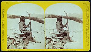
Two famous photographers, Timothy H. O'Sullivan from New York and William Bell from Philadelphia, joined the expedition. They took many pictures of the landscapes and people they encountered. Many of their photographs are now kept safe at the Library of Congress.
The End of an Era
The Wheeler Survey continued until 1879. At that time, it, along with two other major surveys (the King Survey and the Powell Survey), were stopped. Their work was then combined and reorganized to form a new government agency called the United States Geological Survey (USGS).
Places Named After Wheeler
Several places in the American West are named in honor of George Wheeler:
- Wheeler Peak in Nevada, which is part of the Great Basin National Park.
- Wheeler Peak in New Mexico, which is the highest point in that state.
- The beautiful Wheeler Geologic Area in southern Colorado.
 | Victor J. Glover |
 | Yvonne Cagle |
 | Jeanette Epps |
 | Bernard A. Harris Jr. |

