
Tabasco (state) facts for kids
Quick facts for kids
State of Tabasco
|
|||
|---|---|---|---|
|
|||

Location within Mexico
|
|||
| Country | |||
| Capital | Villahermosa | ||
| Municipalities | 17 in 4 zones | ||
| Area
Ranked 24th |
|||
| • Total | 25,267 km2 (9,756 sq mi) | ||
| Population
(2005)
|
|||
| • Total | 1,989,969 (Ranked 20th) | ||
| Time zone | UTC-6 (CST) | ||
| • Summer (DST) | UTC-5 (CDT) | ||
| HDI (2004) | 0.7684 - medium Ranked 21st |
||
| ISO 3166-2 | MX-TAB | ||
| Postal abbr. | Tab. | ||
| Website | Tabasco State Government | ||


Tabasco, officially known as the Free and Sovereign State of Tabasco, is one of the 32 states that make up Mexico. It is divided into 17 areas called municipalities, and its capital city is Villahermosa. Tabasco is located in the southeast part of Mexico. It shares borders with Campeche to the northeast, Veracruz to the west, and Chiapas to the south. To the southeast, it borders the Petén area of Guatemala. To the north, it has a coastline along the Gulf of Mexico.
Most of Tabasco is covered in rainforests. This is because it gets a lot of rain all year round, unlike many other parts of Mexico. Because of all the rain, the state also has many small lakes, wetlands, and rivers. Tabasco sometimes experiences big floods, like the one in 2007 that covered 80% of the state. The state is also home to La Venta, a very important site of the Olmec civilization. The Olmecs are thought to be the first major culture in ancient Mesoamerica. Even though Tabasco produces a lot of oil and natural gas, many people there still face poverty.
Geography and Environment
Tabasco is in southeastern Mexico. It borders the states of Campeche, Chiapas, and Veracruz. To the north is the Gulf of Mexico, and to the south and east is Guatemala. The state covers about 24,731 square kilometers (9,549 sq mi). This is about 1.3% of Mexico's total area. The northwestern part of Tabasco is a flat coastal plain. The southern and eastern parts are higher, being part of a mountain range that goes into northern Chiapas.
The state is divided into 17 municipalities. There are 36 urban areas and about 3,000 smaller towns and villages. 185 of these are called "regional development centers." The 17 municipalities are: Balancán, Cárdenas, Centla, Centro (Villahermosa), Comalcalco, Cunduacán, Emiliano Zapata, Huimanguillo, Jalapa, Jalpa de Méndez, Jonuta, Macuspana, Nacajuca, Paraíso, Tacotalpa, Teapa and Tenosique.

In 1994, Tabasco was split into two main regions: Grijalva and Usumacinta. This was done to help with development and to organize geographic information. The Grijalva Region is named after the Grijalva River. Many towns here depend on this river. It is smaller, covering about 12,069 square kilometers (4,660 sq mi). However, most of Tabasco's city dwellers and economic activities are in this region. It has three sub-regions: Chontalpa, Centro, and Sierra.
The Usumacinta Region is named after the Usumacinta River, which is the main river for the Centla, Jonuta, Emiliano Zapata, Balancán, and Tenosique municipalities. This region is more rural than the Grijalva Region. It is divided into the Pantanos and Ríos subregions.
Land and Water Features
Tabasco's land has wide, flat floodplains, some mountains, and valleys. Most of the state is covered by tropical rainforests and wetlands. You can also find savannas, beaches, and mangrove forests. Sadly, much of the rainforest has been cut down for logging or to create farmland. The eastern part of the state is made of low, wet plains. These plains are formed by dirt carried by many rivers. In some areas, there are swampy spots that flood easily from rivers or heavy rain.
In the south, there are some hills that are part of the Chiapas mountains. The most important hills are El Madrigal, La Campana, and El Tortuguero. However, most hills in Tabasco are not very high, usually less than 30 meters (98 ft) above sea level.

Tabasco has about 198.8 kilometers (123.5 mi) of coastline. It also has 29,800 hectares (73,600 acres) of estuaries, lakes, and many rivers and streams. Important rivers include the Mezcalapa, Usumacinta, and Tonalá. Almost all of the state's rivers belong to the Usumacinta River basin or the Grijalva River basin. These are the two largest river systems in Mexico. All these rivers eventually flow into the Gulf of Mexico. Along the coast, there are many lagoons and some lakes inland. The most important ones are El Carmen, Pajonal, and Mecoacán. Because the land is flat, rivers can pool in low areas. Tabasco has a huge amount of fresh water, about 35% of all the fresh water in Mexico. Flooding is common, especially from September to November.

Amazing Animals and Plants
Tabasco has four main types of natural areas: tropical rainforest, tropical savanna, beaches, and wetlands. Tropical rainforest covers most of the state because of the heavy rainfall. However, much of the original forest is gone due to logging and farming. The best-preserved rainforests are found in areas like Tenosique and Macuspana.
These rainforests are home to trees like mahogany, cedar, and many types of palms. You can also find different kinds of orchids and a native cactus. This environment has a wide variety of wildlife. You might see macaws, parrots, quetzals, hummingbirds, iguanas, and many types of snakes. Some mammals, like spider monkeys, jaguars, pumas, and deer, still live here, though their numbers have decreased due to forest loss.
Tropical savanna areas are mostly in the southern part of the state. They have lots of grasses and bushes, along with smaller trees. Animals like rabbits, deer, foxes, and various birds live in the savanna.
Along the coast, the soil is sandy. The plants here are tropical but different from those inland. They include coconut palms and royal palms. These areas have also been affected by farming.
The beaches and wetlands are also important. The beach areas have plants that can handle salty soil. The wetlands have some of the largest mangrove forests in Mexico. These are found around lagoons and along riverbanks. The Pantanos de Centla Biosphere Reserve protects many of these wetlands. The fresh water in wetlands and rivers supports many aquatic animals. These include freshwater gar, mojarra, crocodiles, turtles, frogs, and many types of birds. In larger waters, you might even spot manatees. In the salty lagoons, you can find ocean fish, shellfish, and birds like seagulls and pelicans.
Climate and Protected Areas
Tabasco has a hot, tropical climate. The Gulf of Mexico greatly influences its weather. Over 95% of the state has a hot and wet climate. The average yearly temperature is 27°C (81°F). High temperatures average 36°C (97°F) in May, and lows are around 18.5°C (65°F) in January. Tabasco gets a lot of rain all year, averaging 2,550 millimeters (100 in) annually. Rain is especially heavy from June to October. The flat areas often flood because of rivers flowing from the Sierra region and the Usumacinta River. Dams built for electricity and flood control, like Angostura and Chicoasén, can also overflow.
Tabasco has 17,138 hectares (42,350 acres) of protected lands. These include the Agua Blanca waterfalls and the Sierra State Park. The Grutas de Coconá caves are a natural monument. The Centla Biosphere Reserve is very large, covering 302,706 hectares (748,000 acres). Other protected areas include Yumká Park and the Laguna de las Ilusiones Ecological Reserves.
Economy

Tabasco's economy makes up about 3.4% of Mexico's total economy. Even though the state has seen a boost from oil, poverty is still a big issue in some areas. In cities, most homes have running water, sewage, and electricity. But in rural areas, only about 40% have running water, less than 70% have sewage, and less than 85% have electricity. About 150,000 families, or half a million people, live in poverty in Tabasco. This is mostly due to a lack of jobs. The poorest areas are often those without major industries, like Jonuta and Tacotalpa.
The heavy rainfall in Tabasco makes it hard to grow annual crops, and frequent flooding is a problem. Still, the state produces a good amount of corn, sorghum, and beans. Most important commercial crops are plants that grow for many years, like cacao, coconut, oranges, bananas, and sugar cane. There are also large areas of natural grasslands for animals. Because of the climate, a type of cattle called Zebu does very well here and is mostly raised for meat. Cattle farming makes up about three-quarters of the meat produced in the state. Other farm animals include pigs, sheep, goats, and chickens. Most of these animals are raised near Villahermosa and Cárdenas.

Tabasco has both saltwater and freshwater fishing along its coast and in its many rivers and lakes. However, fishing is not a huge industry, providing less than 2% of Mexico's total fish production. Popular fish and seafood include oysters, mojarra, shrimp, sea bass, and shark. Most fishing boats are based in Frontera. The state also has natural resources like mahogany, cedar, and other tropical hardwoods.
Mining, especially for oil and natural gas, brings in most of the state's money. However, only a small part of the working population (14.6%) works in mining. About 19% work in construction, transportation, and manufacturing. Most manufacturing involves processing food, bottling drinks, and making tobacco products. About 90% of industrial businesses are small, family-owned companies, mostly focused on food processing around Villahermosa. The most important industry is oil refining, done by PEMEX in Macuspana. There are 860 wells in various towns that extract crude oil and natural gas. Tabasco produces a lot of oil and gas every day. The state also has deposits of gravel and sand.
Just over 61% of the working population works in services and commerce. There are 86 traditional public markets. The Tabasco Fair is the most important business event. It started in 1880 and has been held on and off in different places since then. Today, it takes place in Villahermosa at Parque Tabasco 2000. Here, different municipalities show off their products. The fair also includes cultural and sports events.
Tourism
Tourism in Tabasco is organized into different "routes" or tours.
Villahermosa Route
The Centro or Villahermosa Route focuses on the state capital. Here you can visit museums and historic buildings. These include the Cultural Center of Villahermosa, the Regional Anthropology Museum, and the Tomás Garrido Canabal Park. You can also explore the Yumka’ Ecological Reserve, the Paseo Tabasco Malecon Tourist Corridor, the Papagayo Interactive Museum, and the Tabasco Cathedral.
Cacao Route
The Cacao Route takes you to various cacao farms. Guides teach you how the cacao plant is grown and how the beans are harvested. You also learn how cacao is turned into chocolate. This route also includes a visit to the Comalcalco archeological site. The Cacao Route covers towns like Nacajuca, Jalpa de Méndez, Comalcalco, and Paraíso. In Nacajuca, you can see the boardwalk, buy handicrafts, and visit Chontal villages where old customs and the Chontal language are still alive. In Jalpa de Méndez, check out gourd handicrafts, the San Remo cigar factory, and the La Encantada Turtle Farm. In Comalcalco, visit the Comalcalco archeological site and cacao farms like La Luz, which has a Cacao Museum. Paraíso is a small port town with beaches and resorts.
River Adventure Route
The River Route is in the middle of the state, between the Grijalva and Usumacinta Rivers. This is an ecotourism route with fun activities like canopy climbing, rafting, and rappelling. You can also visit the Pomoná archeological site. This route includes the Cascadas de Reforma Ecological Reserve and the Reforma Mayan archeological site.
Wetlands Route
The Wetlands Route highlights the plants and animals found in Tabasco's wetlands and water. The main attraction is the Centla Biosphere Reserve. This reserve is home to many wildlife species, such as herons, storks, crocodiles, turtles, and manatees. It also has over 500 plant species, including many aquatic plants. Other places to visit include the Centla maritime port, the Museum of Navigation, and the town of Frontera. Beaches in this area include Pico de Oro and Playa Azul.
Mountain Adventure Route
The Mountain Adventure Route is in the higher parts of the state. It features forests, sulfur springs, and caves. It centers around the town of Tapijulapa, known for its wood and wicker handicrafts. This route explores the hills, rainforests, and caves in the Teapa, Tacotalpa, and Macuspana municipalities. You can visit the Río Puyacateno Park, Los Azufres Hacienda and Spa, and the Coconá Caverns. Fun activities include spelunking (exploring caves), rappelling, and hiking.
Olmec Zoque Route
The Olmec Zoque Route includes the municipalities of Cardenas and Huimanguillo. Cardenas is near the ocean and has fishing villages. Huimanguillo has archeological sites and natural attractions. The most famous is La Venta, an Olmec site. Another important site is Malpasito, which belongs to the Zoque culture. You can also find tropical rainforests, waterfalls, petroglyphs (rock carvings), and lakes here.
Biji Yokot’an Route
The Biji Yokot’an Route focuses on the municipality of Nacajuca. It features local crafts, like decorated gourds, and delicious food, especially river fish. You can also learn about the Chontal people who live here and enjoy the river boardwalk.
| Ecological and adventure tourism in Tabasco | ||||
 |
 |
 |
 |
 |
| Pantanos de Centla | Desarrollo Ecoturístico "Kolem-Jaa" | Cascadas de Aguas Blancas | Puerto Ceiba | Cañón del Usumacinta |
 |
 |
 |
 |
 |
| Grutas del Coconá | Sierra de Tabasco | Rápidos de San José-Desempeño | El Bellote | Tapijulapa |
Culture
Traditional Dress
Traditional clothing for men in Tabasco includes a white shirt and pants. They wear black boots or shoes, a black belt, and a hat called a "chontal" style hat. A red handkerchief is tied around the neck. This outfit comes from an older style of work clothes made from cotton fabric.
Traditional clothing for women includes a wide skirt with a ruffle. Underneath, there's a slip to make the skirt look fuller and the waist smaller. The blouse is white with a colorful embroidered band, often with flower or animal designs. It has short sleeves. Women often carry a small handkerchief and a colorful shawl called a rebozo. Shoes are black.
| Traditional dress of Tabasco | ||||
 |
 |
 |
||
| Regional everyday dress | Regional semi-formal dress | Regional formal dress | ||
Dances and Music
Tabasco has many unique traditional dances. This is because it was quite isolated from the rest of Mexico for a long time. Some dances include "El Gigante," performed in Nacajuca. "Baila Viejo" is danced in Tucta and Guaytalpa. "El Pochó" is a very old dance from before the Spanish arrived. It is performed during Carnival in Tenosique. "Los Blanquitos" also takes place in Tenosique and tells the story of enslaved people during colonial times. "El Caballito Blanco" shows the fight between the native people and the Spanish. "El Zapateo" is the state's official regional dance. It is said to come from a Spanish dance called fandango.
.jpg)

Traditional music in Tabasco has roots in the Olmec period and other native cultures like the Maya and Nahuas. It mainly uses flutes and drums made from tortoise shells. Purely native music has mostly disappeared, replaced by music with European influences. The fandango dance style was one of the first European influences. It changed into a style called fandanguillo, which led to songs called zapateos during the colonial period. These were played by small orchestras, often with wind instruments, marimbas, and drums called temborileros. This music was played for the "Zapateo" dance. Later, short, funny rhymes called "bombas" were added.
Delicious Cuisine
Tabasco's food is based on the ancient Mayas and Chontals. It uses local plants and animals like achiote, chili peppers, and banana leaves. Corn and beans are key ingredients. Traditionally, people in Tabasco eat seven times a day! This schedule comes from old farming customs. Typical dishes include those with iguana meat, a fish called Lepisosteus, beef stew, smoked oysters, and tortillas made with banana and fresh corn. Chocolate drinks, both hot and cold, are still made the same way as in ancient times. The most common cold chocolate drink is pozol.
Each region has its own special foods. Teapa is known for its cheese and longaniza sausage. Jalpa de Méndez makes head cheese and another cured meat called butifarra. Macuspana's dishes often use ingredients from its rivers, like bass and turtle. Paraíso is famous for its oysters, often cooked in their shells. Jalapa is known for its sweets, like sweetened fruits in corn husks, often with a cacao and corn drink called chorote.
Tabasco also hosts a boating marathon called the Mundo Maya on the Usumacinta and Grijalva rivers.
Museums and Festivals
The state has 16 important museums. Most are in the Villahermosa area. Others are in towns like Comalcalco, Huimanguillo, and Teapa. These include the Carlos Pellicer Museum (anthropology), the Museum of Popular Culture, and the La Venta site museum.
Festivals honoring patron saints are still popular. Some well-known ones are San Isidro in Comalcalco and Nacajuca, and James the Greater in Chontalpa. There are also big Carnival celebrations in Pochó, Tenosique, and Villahermosa.
Archaeology
La Venta: Ancient Olmec City

La Venta was the most important religious center of the Olmec civilization. The Olmecs were the first major culture in ancient Mesoamerica. At this site, you can see many features of Olmec culture. These include images of jaguars, huge colossal heads, and statues of round children. The site dates back to about 1000 BC and became less important around 400 AD.
The museum connected to La Venta is in Villahermosa. It's called Parque Museo de la Venta. It has 33 major pieces from the site. The museum also shows how the Olmecs lived, their government, their knowledge of stars, and their writing. This park was created in the 1950s to protect the most important artifacts from the archeological site. It also has exhibits about the plants and animals of the area.
Comalcalco: Maya City of Adobe
Comalcalco is a Maya archeological site near the modern city of the same name. It's located on the Mezcalapa River. This is one of the few Mayan cities where the large buildings are made of adobe bricks instead of stone. It's the only one that has been largely rebuilt and is open to visitors. The Mayas used adobe because there wasn't much building stone nearby. Instead, they used the plentiful clay and lime from shells. This Mayan city grew between 800 and 1100 AD, at the same time as Palenque. The name "Comalcalco" means "place of comals" (a type of cooking pan) in Nahuatl. Its Mayan name was Hoi Chan, meaning "cloudy sky." The site covers a large area with 282 structures. The main buildings are La Plaza Norte, La Gran Acropolis, and the Eastern Acropolis.
Malpasito: Zoque Culture Site
Malpasito is near a modern town of the same name. This site is linked to the Zoque culture. It was at its peak between 250 and 400 AD. So far, only parts of the site have been explored. The buildings here are on artificial terraces, with 27 mounds. These structures include a Mesoamerican ball court, a main plaza, and a sunken patio. The site also has 60 petroglyphs, which are carvings on rocks.
Pomoná: A River Trading Hub
Pomoná is a Mayan site found in 1959. This city was built during the Classic period, reaching its peak later in that period. It declined in the early Post Classic period. Pomoná is on the Usumacinta River. This location made it very important for trade and politics at the time. Many goods from the ocean passed through here on their way to the Peten area. We don't know its original name; it's named after a nearby modern town. It has six main groups of buildings, with homes spread over a large area.
Reforma: Another Mayan Mystery
Reforma, also known as Morales or Moral, is another Mayan site. There isn't much information about this site, but it had a ruling family by 633 AD. It was connected to Pomoná, Palenque, and Bonampak through politics and trade. The main plazas and ceremonial buildings here are similar to those found in Tikal. There are seven main structures surrounded by many smaller ones. Many of the stone carvings from this site are now in the José Gómez Panaco Museum in Balancán.
| Archaeological and colonial tourism in Tabasco | |||||||
 |
 |
 |
 |
 |
|||
| La Venta | Comalcalco | Pomoná | Moral-Reforma | Olmec Head, La Venta Park | |||
 |
 |
 |
 |
 |
|||
| Oxolotán | Cunduacán | Cupilco | Villahermosa | Tapijulapa | |||
Images for kids
-
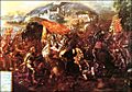
The Entrance of Hernán Cortés into the City of Tabasco
-
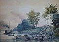
Image of the U.S. invasion of Villahermosa
-
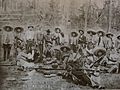
Group of revolutionaries from Tabasco
-
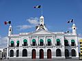
Government Palace of Tabasco in Villahermosa.
-
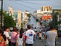
Scene from the 2007 floods
-

Villahermosa international airport


See also
 In Spanish: Tabasco para niños
