
Mesoamerica facts for kids

Mesoamerica means "central America." It is a large area that stretches from central Mexico all the way down to Costa Rica. This name is mostly used to talk about the amazing native people and their cultures that lived there long before the Spanish arrived.
Contents
Exploring Mesoamerica's Geography
_-_Guatemala_1828_-_La_Danta_at_the_Mayan_site_of_El_Mirador.jpg)

Mesoamerica is a land full of different natural areas. It sits on a narrow strip of land that connects North and South America. This region has two main types of areas:
- The lowlands: These are areas from sea level up to 1,000 meters high. They usually have warm, tropical weather.
- The highlands: These areas are between 1,000 and 2,000 meters high. They have many different climates, from dry to cool mountain weather. Most of the highlands have a mild, temperate climate with good rainfall.
The amount of rain changes a lot across Mesoamerica. Some parts, like Oaxaca and northern Yucatán, are dry. Other parts, like the southern Pacific and Caribbean coasts, get a lot of rain.
Different Cultural Areas
Mesoamerica can be split into several smaller areas. Each area has its own unique geography and cultural features. For example, the Maya area is divided into lowlands and highlands.
- The southern Maya lowlands include northern Guatemala, southern Campeche and Quintana Roo in Mexico, and Belize.
- The northern lowlands cover the rest of the northern Yucatán Peninsula.
Other important areas are Central Mexico, West Mexico, the Gulf Coast, Oaxaca, and Southeast Mesoamerica (which includes northern Honduras).
Mountains and Volcanoes
Mesoamerica has many different land shapes. It has high mountains around the Valley of Mexico and flat lands in the northern Yucatán. The tallest mountain is Pico de Orizaba. It is a dormant volcano on the border of Puebla and Veracruz. It stands 5,636 meters (18,490 feet) tall.
The Sierra Madre mountains run through Mesoamerica, from north to south. Many of these mountains are volcanoes. There are 83 inactive and active volcanoes in this range. Sixteen of them are still active today. The tallest active volcano is Popocatépetl. It is 5,452 meters (17,887 feet) tall and is located near Mexico City.
One important flat area is the Isthmus of Tehuantepec. This low plateau breaks up the Sierra Madre mountains. It is the shortest distance between the Gulf of Mexico and the Pacific Ocean in Mexico. This area was a very important route for travel, communication, and trade in ancient Mesoamerica.
Rivers and Lakes
Many rivers flow through Mesoamerica, except for the northern Maya lowlands. These rivers were important places for people to live. The longest river is the Usumacinta. It flows for 970 kilometers (600 miles) through Guatemala and into the Gulf of Mexico.
The northern Yucatán Peninsula has almost no rivers. Instead, people get water from underground water sources called aquifers. They reach this water through natural openings called cenotes.
Lake Nicaragua is the largest lake in Mesoamerica, covering 8,264 square kilometers (3,191 square miles). Lake Chapala is Mexico’s largest freshwater lake. Lake Texcoco is famous because the capital of the Aztec Empire, Tenochtitlan, was built on it. Lake Petén Itzá in Guatemala was where the last independent Maya city, Tayasal, resisted the Spanish until 1697.
Amazing Nature
Mesoamerica has almost every kind of ecosystem. It is home to some of the richest biodiversity in the world.
- The Mesoamerican Barrier Reef System is the second largest coral reef in the world.
- La Mosquitia is a huge rainforest. It is the second largest in the Americas, after the Amazon rainforest.
The highlands have mixed and pine forests. Sadly, many species in Mesoamerica are now on the endangered list.
Mesoamerica's History and Cultures

The history of people living in Mesoamerica is divided into different time periods. These periods show how societies changed over time. They also show how people found new ways to get food and trade with others. The main periods are:
- The Paleo-Indian period
- The Archaic period
- The Preclassic (or Formative) period
- The Classic period
- The Postclassic period
After the Spanish arrived in the 1500s, it became the Colonial period.
Paleo-Indian Period
This was the earliest period. People were hunters and gatherers. They moved around a lot to find food. They hunted large animals, much like people in North America at the same time. Tools from this period include sharp obsidian blades and special spear points.
Archaic Period
The Archaic period (8000–2000 BC) is when people started to farm in Mesoamerica. At first, they grew wild plants. Over time, they learned to domesticate plants and began to settle down in one place. This led to more farming by the end of this period. Evidence of early maize (corn) farming from around 3500 BC has been found at sites like Sipacate in Guatemala.
Preclassic / Formative Period

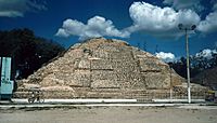
The first major civilization in Mesoamerica was the Olmec. They lived along the Gulf Coast of Veracruz during the Preclassic period. Their main cities were San Lorenzo Tenochtitlán, La Venta, and Tres Zapotes. These cities were active from about 1200 to 400 BC. Other early cultures also interacted with the Olmec.
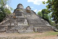
During the Middle and Late Preclassic, the Maya civilization began to grow. Early Maya sites like Nakbe, El Mirador, and Cerros appeared after 1000 BC. Other important Maya sites from this time include Kaminaljuyú, Cival, and San Bartolo.
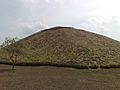
In central Mexico, sites like Tlapacoya and Cuicuilco were important. Later, Teotihuacán became a very powerful city that influenced many other areas. Its settlement began around AD 50.
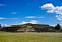
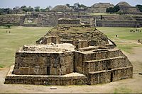
In the Valley of Oaxaca, San José Mogote was one of the oldest farming villages. It was one of the first places to use pottery. This site also showed early signs of defensive walls and ceremonial buildings. It was also one of the first places where leaders inherited their power. Later, Monte Albán became the capital of the Zapotec empire.
Preclassic gallery
-
Cuicuilco 800–600 BC
-
Nakbé, Mid Preclassic (600 BC) Palace remains, The Mirador Basin
-
The partly excavated main structure of San Jose Mogote 1500–500 BC
-
Monte Alban, Building J in the foreground. 200 BC – AD 200


Classic Period
Early Classic

The Classic period saw the rise of several powerful cities. The Early Classic period is mainly defined by the rise of Teotihuacán in central Mexico and Tikal in Guatemala. Teotihuacán was very influential. Its building styles and pottery were copied in many distant settlements. Obsidian (a sharp volcanic glass) from Teotihuacán was traded all over Mesoamerica.
Tikal became a major power in the southern Maya lowlands. It controlled trade and military power. Tikal traded goods like obsidian and jade throughout the region. Tikal often fought with other cities like Uaxactun and Calakmul. Around 562 AD, Tikal was defeated by Caracol, leading to a quiet period for Tikal.
Early Classic gallery
-
Great Goddess of Teotihuacan AD 200–500
-
A reconstruction of Guachimontones, which thrived from AD 200–400
-
Temple of the Owl, Dzibanche AD 200–600
-
Acanceh, AD 200–300
-
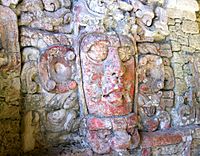
Mask located on the "Temple of the Masks" Kohunlich around AD 500


.jpg)


Late Classic

The Late Classic period (starting around AD 600) was a time of competition among many Maya cities. Tikal's power had lessened, allowing other cities to become more important. These included Caracol, Copán, Palenque, and Calakmul. Around 710 AD, Tikal regained its strength and started building alliances again. In the Maya area, the Late Classic ended with the "Maya collapse." Many cities in the southern lowlands were abandoned, and new centers grew in the northern lowlands.
Late Classic gallery
-
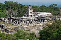
Main palace of Palenque, 7th century AD
-
K'inich Janaab Pakal I of Palenque AD 603–683
-
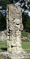
Copan Stela H, ordered by Uaxaclajuun Ub'aah K'awiil AD 695–738
-
Jaina Island type figure (Maya) AD 650–800
-
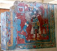
Cacaxtla, Mural showing the Bird Man AD 650–900


.jpg)
.jpg)
Terminal Classic

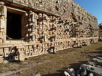
The Terminal Classic (around AD 800/850 to AD 1000) mainly refers to the Maya area. During this time, cities in the northern Maya lowlands, especially those in the Puuc hills, became very important. These cities had a special building style called the "Puuc architectural style." Major Puuc sites include Uxmal, Sayil, and Kabah.
Chichen Itza also grew powerful during this period. It became a major economic and political center in the northern lowlands. Its port, Isla Cerritos, helped it connect with central Mexico and Central America. The "Mexican" building styles at Chichen Itza show strong ties with other regions.
Terminal Classic gallery
-
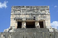
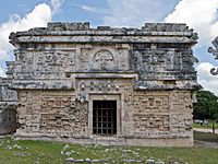
Chichen Itza, Temple of the Jaguars AD 900–1000
-
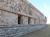
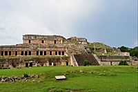
Governor's Palace rear view and details, 10th century AD, Uxmal
-
Temple of the Masks, Kabah
-
Sayil, three-story palace, AD 600–900
-
Chichen Itza, "Temple of Three Dintels" AD 600–1000


.jpg)


Postclassic Period
The Postclassic period (starting AD 900–1000) was another time when different powerful groups rose and fell. After Chichen Itza declined, Mayapán became the main power in the northern Maya lowlands for about 200 years. After Mayapán fell apart, the region was controlled by smaller city-states that competed with each other.

In central Mexico, the Toltec empire, with its capital at Tula, rose to power. Later, the Mexica people and the powerful Aztec Empire became dominant. The Aztecs controlled most of central Mexico, the Gulf Coast, and parts of southern Mexico and Guatemala.
The Tarascans (also known as the P'urhépecha) lived in Michoacán. Their capital was Tzintzuntzan. They were one of the few groups that successfully fought against Aztec rule. Other important Postclassic cultures included the Totonac along the eastern coast and the Mixtec and Zapotec cultures in Oaxaca.
The Postclassic period ended with the arrival of the Spanish between 1519 and 1521. Many groups, like the Maya in the Petén area, continued to fight for independence until 1697.
Some Mesoamerican cultures were not as famous but were still important. These include the Otomi, Mixe–Zoque groups, and the Chichimeca groups in the north.
Postclassic gallery
-
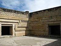
Palace of Mitla, Oaxaca 12th century
-
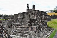
The Calendar temple of Tlatelolco, 1200 AC.
-
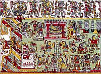
Detail of page 20 from the Codex Zouche-Nuttall, 14-15th century
-
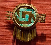
Pectoral mixtec, Shield of Yanhuitlan.
-
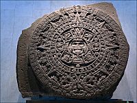
Aztec sun stone, early 16th century


Images for kids
-
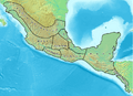
Mesoamerica and its cultural areas
-
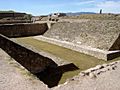
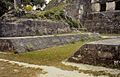
Ballgame court at Monte Albán
-
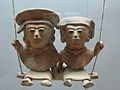
A pair of swinging Remojadas figurines, Classic Veracruz culture, 300 to 900 CE.
-
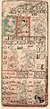
Page 9 of the Dresden Codex (from the 1880 Förstermann edition)
-
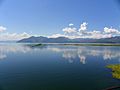
Yojoa Lake in Honduras.
-
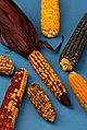
Examples of the diversity of maize
-
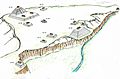
Illustration that recreates the structures of the archaeological site of Yarumela or El Chircal in Honduras, this place reflects the Olmec influence that existed in Central America in the pre-classic period.
-
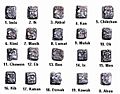
"Head Variant" or "Patron Gods" glyphs for Maya days
-
The emblem glyph of Tikal (Mutal)
-
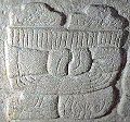
One of the earliest examples of the Mesoamerican writing systems, the Epi-Olmec script on the La Mojarra Stela 1 dated to around 150 CE. Mesoamerica is one of the five places in the world where writing has developed independently.
-

The xoloitzcuintle is one of the naguales of the god Quetzalcoatl. In this form, it helps the dead cross the Chicnahuapan, a river that separates the world of the living from the dead.
-
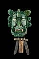
Zapotec mask of the Bat God.
-
A small ceremonial ballcourt at Tikal.
-
Ballgame marker from the classic Lowland Maya site of Chinkultic, Mexico depicting a ballplayer in full gear
-
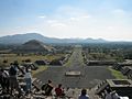
The Avenue of the Dead in Teotihuacán, an example of a Mesoamerican settlement planned according to concepts of directionality
-
Pyramid of the archaeological site of La Venta 1000-400 BCE


.jpg)


See also
 In Spanish: Mesoamérica para niños
