
Tula de Allende facts for kids
Quick facts for kids
Tula de Allende
Mämeni (Otomian languages)
|
||
|---|---|---|
|
Municipality and town
|
||
 |
||
|
||
 |
||

Tula de Allende
Location in Mexico
|
||
| Country | ||
| State | Hidalgo | |
| Municipal seat | Tula de Allende | |
| Area | ||
| • Municipality and town | 305.8 km2 (118.1 sq mi) | |
| Population
(2010)
|
||
| • Municipality and town | 103,919 | |
| • Metro | 188,659 | |
| Area code(s) | 42800 | |
| Website | Main site | |

Tula de Allende (in the Otomi language: Mämeni) is a city and one of the 84 municipalities of Hidalgo in central-eastern Mexico. A municipality is like a county or local government area. This area covers about 305.8 square kilometers (118 sq mi). In 2010, the municipality had a total population of 103,919 people.
The municipality includes many smaller towns. The biggest ones are El Llano, San Marcos, and San Miguel Vindho. Tula de Allende is an important economic hub for its region. It is also one of Mexico's fastest-growing cities. It is most famous for the Tula archeological site. This ancient site is known for its large stone Atlantean figures, which look like warriors. The larger urban area, which includes nearby towns, had 188,659 residents in 2010.
Contents
The City of Tula de Allende

.jpg)
The city of Tula de Allende was built on the southern part of the ancient city of Tula. Its center is an old monastery built by the Spanish in the 1500s. The modern city is still linked to the ancient ruins. These ruins are a major tourist spot and a symbol of the city. The warrior statues on the Quetzalcoatl pyramid are especially famous.
It's common to find ancient Toltec objects under the modern city. For example, in 2009, Toltec burials from 900-1100 CE were found under a street. Pottery kilns were also found there.
The modern city is a key economic center for its region. It has been named one of the fastest-growing cities in Mexico. This growth is mainly because of a large oil refinery and a power plant located nearby.
The city's center is the San Jose church and former monastery. The oldest part of this building was built between 1546 and 1556. The front of the church has three arches and stone carvings. Inside, there is a modern mural called "Jesus" at the main altar. The building became a cathedral in 1961.
Near the cathedral, you'll find a main plaza and an outdoor theater. The theater has a mural called "Tula Eterna" by Juan Pablo Patiño Cornejo. Another mural, "Tianguis Mamehni," is at the chamber of commerce building. There is also a crafts market called Plaza de las Artesanias. Here, you can find local handmade items, including copies of the famous Atlantean figures.
Understanding the Municipality
The city of Tula de Allende is also the main town for a larger area called the municipality. This municipality includes 76 different communities. The city of Tula de Allende is the largest community, with about 27,000 people.
Other important communities in the municipality include:
- El Llano (about 11,000 people)
- San Miguel Vindho (about 10,500 people)
- San Marcos (about 10,400 people)
- Bomintzha (about 3,000 people)
- Santa Ana Ahuehuepan (about 2,600 people)
- Santa Maria Macua (about 1,750 people)
- Ignacio Zaragoza (about 1,750 people)
- Nantzha (about 1,740 people)
- Xochitlan de las Flores (about 1,300 people)
- Colonia San Francisco Bojay (about 1,250 people)
- Monte Alegre (about 1,200 people)
The local government is led by a municipal president. There are also fourteen administrators, 54 delegates, and fourteen special committees.
A Look at Tula's History


The name "Tula" comes from the Nahuatl phrase Tollan-Xicocotitlan. This means "near where cattails grow." Tula is the Spanish way of saying Tollan. In the Otomi language, the area is called Namehi, which means "place of many people." The name "de Allende" was added to honor Ignacio Allende, a hero of the Mexican War of Independence.
This area was once the capital of the Toltec civilization. The Toltecs were a major civilization in Mesoamerica. They became powerful after 713 CE, taking over from Teotihuacan. The modern city of Tula is located just south of the ancient city's main ceremonial center. This ancient site is famous for its large Atlantean figures. The Toltec Empire spread far, reaching south to the Valley of Mexico. Their influence has been found in artifacts as far north as the southwestern United States.
It is believed that aguamiel (a sweet liquid from the agave plant) was first collected here around 1100 CE. This led to the creation of pulque, a traditional Mexican drink. The last Toltec ruler was Topilzin Ce-Acatl Quetzalcoatl, who became ruler in 1085.
Later, the Aztec Empire conquered the site. This happened during the rule of Tizoc, an Aztec emperor.
After the Spanish conquest of the Aztec Empire, a person named Pedro Miahuazochil was made the lord of Tula in 1531. He helped to spread Christianity in the area. Tula officially became a municipality in 1871.
The Tula area also saw many battles during the Mexican Revolution. These fights were mainly between groups loyal to Venustiano Carranza and those loyal to Emiliano Zapata.
Geography and Environment


The municipality of Tula de Allende is in the southern part of the Mezquital Valley. This is in the southwest of the Hidalgo state. It covers an area of 305.8 square kilometers (118 sq mi). It shares borders with several other municipalities and with the State of Mexico to the west.
The city of Tula is about 2,020 meters (6,627 feet) above sea level. Most of the municipality is fairly flat. There is one important hill called Magoni entirely within the municipality. Hills in the west form the border with the State of Mexico. These include Magueni and La Malinche. In the north, there is a small volcano-shaped mountain called Xicuco.
Most of the surface water comes from the Tula River, the Rosas River, and the Arroyo Grande. Their waters are stored in the Endho Dam. The Tula River gets its water from the Valley of Mexico. The Rosas River also starts in the State of Mexico, but its waters are clean from a fresh spring. This river has carved some small canyons in the area.
Unfortunately, there are pollution problems here. These mostly come from the PEMEX oil refinery and from wastewater that flows into the Tula River from the Valley of Mexico.
Plants and Animals of Tula
The natural plant life in Tula is mostly like a semi-desert. You will see many cactus and maguey plants. There are also mesquite trees and pirul trees (also known as the Schinus molle). Seasonal grasses also grow here.
The native animals include rabbits, squirrels, chameleons, roadrunners, and coyotes. You might also spot various kinds of birds and snakes, skunks, and opossums.
Tula's Climate
The climate in the municipality changes from mild to cool. The average temperature each year is about 17.6°C (63.7°F). It gets about 699 millimeters (27.5 inches) of rain each year. Most of the rain falls between May and September.
Tula's Economy
The city and municipality have a good economic standing. The average household income is between US$5,037 and $10,641 per year. Tula is a major economic center for its region. Its economic influence reaches several nearby municipalities.
Most people who work in Tula are in commerce, services, and tourism (about 55%). About 33% work in manufacturing and mining. Less than 10% work in farming and raising animals. Most of the land (97%) is used for farming. The main crops grown are corn, beans, oats, and wheat. Farmers also grow vegetables like squash, tomatillos, and chili peppers. Other crops include alfalfa, nopal cactus, cactus fruit, peaches, and avocados. People raise sheep, goats, cattle, pigs, and chickens. Fishing is mostly for fun, catching carp and catfish.

.jpg)
There are also companies that make things, extract minerals, and build structures. Some important ones are the Francisco Pérez Ríos Thermoelectric plant and the PEMEX oil refinery. There are also cement factories like Cruz Azul and Tolteca. The PEMEX refinery started in 1976. It makes gasoline, diesel, and solvents. It covers a large area and processes almost 25% of Mexico's crude oil. About 3,500 people work there.
A special local craft is making copies of the ancient Toltec stone figures. These Atlantean figures are recreated using wax, marble, plastic, and clay. People also make textiles like quezquémetl (a type of poncho), rebozos (shawls), sarapes (blankets), hats, and baskets.
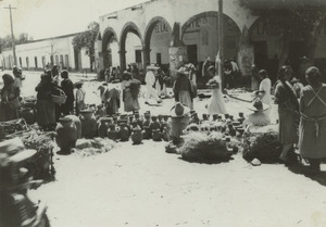
Local markets sell groceries and clothes. There are two main traditional markets in Tula city: the municipal market and the Tianguis. The Tianguis often focuses on electronics.
Tourism is a big part of the service sector. Many visitors come to see the Tula archeological site. Other attractions include the Requena dam, where people can boat, fish, and picnic. There's also the Parque Acuático la Cantera, a water park with a pool and warm springs. The municipality has several hotels for visitors.
Tula has good transportation. It has federal and state highways, and rural roads. There are also about 40 kilometers (25 mi) of train tracks. It has a main bus station for local and long-distance travel. Trains pass through regularly on routes like Mexico City–Ciudad Juárez and Mexico City–Tula–Querétaro. Tula also has very old telegraph and postal services, both over 100 years old. There are two local radio stations.
Population Information

Communities in Tula de Allende
| Town | Population |
| Total | 103,919 |
| Tula de Allende | 28,577 |
| San Miguel Vindho | 7,988 |
| Bomintzha | 3,568 |
| Santa Ana Ahuehuepan | 2,917 |
| Santa María Macua | 2,197 |
| Xochitlán de las Flores | 1,595 |
| Michimaloya | 1,242 |
| Xitejé de Zapata | 1,004 |
The 2010 census counted 103,919 people living in the municipality. This included 53,429 females and 50,490 males. There were 26,937 households. About 581 people spoke an indigenous language.
The Tula de Allende municipality is quite large. It includes many cities, towns, and smaller communities. The biggest city is Tula de Allende. The second largest is Cruz Azul City, which is near San Miguel Vindho and Santa María Ilucan. The Tula-Tepeji area is the third largest urban area in Hidalgo state. It is the most important population center in the Mezquital valley.
Culture and Education
Most of the people in Tula (87%) are Catholic. The main celebration day is March 19, dedicated to Saint Joseph. There is also a large yearly pilgrimage from Tula to the Basilica of Guadalupe in Mexico City. Many people walk this journey.
Traditional clothing for men includes pants and a shirt made of plain cotton cloth, along with a sombrero. For women, traditional dress is a cotton dress, often with a full skirt underneath. It is decorated with ribbons and embroidery, sometimes with beads and sequins. A wool rebozo (shawl) is common in winter. For charreada events (Mexican rodeo), men might wear charro outfits. Women might wear China Poblana dresses.
Traditional dishes in the area include barbacoa (slow-cooked meat), carnitas (fried pork), and pulque (an alcoholic drink). Other dishes are nopal cactus with eggs, beans with epazote (an herb), and mixote (meat or fish cooked in a wrapper). The area is especially known for dishes made with escamoles (ant eggs) and mezcal worms, which are seasonal foods. Street food like gorditas is popular in local markets.
The most important museum in the municipality is the Jorge R. Acosta Museum. It is located at the Tula archeological site and is managed by INAH (Mexico's National Institute of Anthropology and History).
The municipality has many schools. There are 73 preschools, 66 primary schools, 30 middle schools, and thirteen high schools. For higher education, there is the Universidad Politecnica de la Energia and the Universidad Tecnológica de Tula-Tepeji. In total, about 30,000 students attend schools here. While there are enough schools for younger students, there are fewer options for higher education.
The Ancient Tula Archeological Site
.jpg)
The main ceremonial area of ancient Tula is just a five-minute drive from the modern city center. Tula became the most important city in its region after the great city of Teotihuacan fell. However, Tula never grew as large as Teotihuacan because other cities were also powerful. Tula is often thought to be the capital of the Toltec civilization around 980 CE. The city was destroyed sometime between 1168 and 1179.
The ancient site is located where two rivers meet: the Río Rosas and the Río Tula. The two largest groups of grand buildings are called "Tula Grande" and "Tula Chico." "Tula Grande" is the most visited part by tourists. Remains of other buildings spread out for some distance in all directions.
Tula Grande has pyramids, Mesoamerican ball courts, and other structures. But its most famous features are the Atlantean figures. These are tall columns shaped like warriors. Another unique feature is the "Serpent Wall," which has carvings that inspired similar designs in later cultures.
The Mexican government made the archeological site a national park in 1981. The park covers an area of 1 square kilometer (0.39 sq mi).
|
See also
 In Spanish: Tula de Allende para niños
