
Chichen Itza facts for kids

The Temple of Kukulcán (El Castillo) is the most famous of the buildings in Chichen Itza.
|
|

Location in Mesoamerica
|
|
| Location | Yucatán, Mexico |
|---|---|
| Region | Yucatán |
| Coordinates | 20°40′59″N 88°34′7″W / 20.68306°N 88.56861°W |
| History | |
| Periods | Late Classic to Early Postclassic |
| Cultures | Maya civilization |
| Official name | Pre-Hispanic City of Chichen-Itza |
| Type | Cultural |
| Criteria | i, ii, iii |
| Designated | 1988 (12th session) |
| Reference no. | 483 |
| Region | Latin America and the Caribbean |
Chichén Itzá is an amazing ancient city built by the Maya people long ago. It's located in Yucatán, Mexico. This city was a very important place in the Maya world for hundreds of years.
Chichén Itzá was a big center for the Maya from about 600 AD to 1200 AD. You can see many different building styles there. Some styles are like those found in central Mexico. Others are like the Puuc and Chenes styles from the northern Maya lowlands.
Experts used to think these different styles meant people from central Mexico took over Chichén Itzá. Now, most believe it was more about different cultures sharing ideas. Chichén Itzá was one of the largest Maya cities. It might have been one of the famous "great cities" mentioned in old Maya stories.
The city probably had many different kinds of people living there. This mix of cultures could explain why its buildings look so varied. Today, the ruins of Chichén Itzá belong to the Mexican government. It's a very popular place to visit, with millions of tourists each year.
Contents
- What Does the Name Chichén Itzá Mean?
- Where is Chichén Itzá Located?
- How Was Chichén Itzá Governed?
- What Was Chichén Itzá's Economy Like?
- A Brief History of Chichén Itzá
- Exploring the Ancient City of Chichén Itzá
- The Great Museum of Chichén Itzá
- Visiting Chichén Itzá Today
- Images for kids
- See also
What Does the Name Chichén Itzá Mean?
.jpg)
The name "Chichen Itza" comes from the Maya language. It means "At the mouth of the well of the Itza."
Chi' means "mouth" or "edge." Chʼen or chʼeʼen means "well." The Itzá were a powerful group of people who ruled the northern part of the Yucatán.
One idea for the meaning of Itza is "enchanter of the water." This comes from its (sorcerer) and ha (water).
Before the Itza people arrived, the city had another name. It was called Uuc Yabnal, which might mean "Seven Great House." This older name is found in ancient Maya books and carvings.
Where is Chichén Itzá Located?

Chichén Itzá is in the eastern part of the Yucatán state in Mexico. The northern Yucatán Peninsula is made of limestone. This means rivers often flow underground.
There are four natural sinkholes, called cenotes, in Chichén Itzá. These cenotes provided plenty of water all year. This made the area a great place for people to settle.
The most famous cenote is the "Cenote Sagrado," or "Sacred Cenote." In 2015, scientists found a hidden cenote under the Temple of Kukulkan. No archaeologists have seen this hidden cenote yet.
Long ago, the Maya people used the Sacred Cenote for special offerings. They would place objects and sometimes people into the cenote. This was a way to worship their rain god, Chaac.
In the early 1900s, explorer Edward Herbert Thompson explored the Sacred Cenote. He found many items like gold, jade, pottery, and incense. He also found human remains. Studies of these remains show injuries that fit with ancient offering practices.
How Was Chichén Itzá Governed?

Some archaeologists once thought Chichén Itzá was ruled differently from other Maya cities. They believed it might have been governed by a council of important families. This system was called "multepal."
However, newer research suggests this idea might not be correct. Today, many experts think Chichén Itzá was likely ruled by powerful kings. This was similar to how other Maya kingdoms operated.
What Was Chichén Itzá's Economy Like?
Chichén Itzá was a very important trading center in the northern Maya lowlands. It was at its strongest during this time. The city used a port called Isla Cerritos on the north coast.
Through this port, Chichén Itzá traded by water with distant places. They got things they couldn't find locally, like obsidian from central Mexico. They also got gold from southern Central America.
Between 900 AD and 1050 AD, Chichén Itzá grew into a powerful capital. It controlled a large area of Yucatán. Its trading port, Isla Cerritos, helped it become very wealthy.
A Brief History of Chichén Itzá
The main part of Chichén Itzá was first built between 750 and 900 AD. Its final design took shape after 900 AD. By the 10th century, the city became a major regional capital. It controlled a large area from central Yucatán to the coast.
The oldest Maya writing found at Chichén Itzá dates to 832 AD. The newest known date is from 998 AD.
How Chichén Itzá Grew
Chichén Itzá became important around 600 AD. But it really became a major capital later, around 800-900 AD. It took control of political, social, economic, and religious life in the northern Maya lowlands.
As Chichén Itzá grew, other cities like Yaxuna and Coba began to decline. These cities were allies, with Yaxuna depending on Coba. Chichén Itzá might have played a part in the downfall of both cities.
The Decline of Chichén Itzá
Some old Maya stories say that a ruler named Hunac Ceel from Mayapan conquered Chichén Itzá in the 13th century. These stories claim Hunac Ceel predicted his own rise to power. He supposedly jumped into the Sacred Cenote and survived, then made a prophecy.
Archaeological evidence suggests Chichén Itzá was attacked and looted at some point. However, it seems this happened before Mayapan became powerful. Most evidence now shows that Chichén Itzá started to decline as a major center by 1100 AD. This was before Mayapan rose to power.
Even after its leaders left, the city might not have been completely empty. When the Spanish arrived, they found many Maya people living in the area. The Sacred Cenote also remained a special place for pilgrimages.
The Spanish Conquest of Chichén Itzá
In 1526, a Spanish explorer named Francisco de Montejo got permission to conquer Yucatán. His son, Francisco Montejo The Younger, tried to conquer the interior in 1532. His goal was to make Chichén Itzá his capital.
Montejo the Younger arrived at Chichén Itzá and renamed it Ciudad Real. At first, there was no resistance. But the Maya soon became hostile. They surrounded the Spanish, cutting off their supplies.
The Spanish were trapped among the ruins. Montejo the Younger tried a big attack against the Maya but lost many soldiers. He had to leave Chichén Itzá secretly in 1534. By 1535, all Spanish had been driven out of the Yucatán.
Later, Montejo returned with a large army of Spanish and Maya allies. He eventually conquered the peninsula. By 1588, Chichén Itzá was part of a working cattle ranch.
Modern Discoveries at Chichén Itzá

Chichén Itzá became famous in 1843 with a book by John Lloyd Stephens. His book, Incidents of Travel in Yucatan, had amazing drawings by Frederick Catherwood. This book made many people want to explore the Maya cities.
In the 1880s, explorers like Teobert Maler and Alfred Maudslay took many photos. Maudslay published the first detailed description of Chichén Itzá.

In 1894, Edward Herbert Thompson, the US Consul to Yucatán, bought the land that included the ruins. For 30 years, Thompson explored the ancient city. He is most famous for exploring the Sacred Cenote from 1904 to 1910. He found gold, copper, jade, and even ancient Maya cloth and wooden weapons. Thompson sent most of these items to Harvard University.
In the 1920s, the Mexican government allowed the Carnegie Institution to do archaeological research. They excavated and restored important buildings like the Temple of Warriors and the Caracol. The Mexican government also restored El Castillo and the Great Ball Court.

In 1926, the Mexican government accused Edward Thompson of stealing artifacts. They took over his property. Thompson, who was in the United States, never returned to Yucatán. In 1944, a court ruled that Thompson had done nothing wrong. His heirs sold the land to a tourism pioneer.

Later, there were two more expeditions to find artifacts in the Sacred Cenote. Today, Mexico's Instituto Nacional de Antropología e Historia (INAH) continues to excavate and restore monuments. In 2009, archaeologists began new excavations near El Castillo. They wanted to learn about older buildings beneath it.
Exploring the Ancient City of Chichén Itzá

Chichén Itzá was one of the biggest Maya cities. Its main area, with many buildings, covered about 5 square kilometers (2 square miles). The city was built on uneven land, which the Maya leveled to create platforms for their buildings.
Many beautiful stone buildings are still standing, and many have been restored. These buildings were connected by paved roads called sacbeob. Archaeologists have found over 80 of these roads.
Imagine the city in ancient times: many of these stone buildings were painted in bright red, green, blue, and purple colors! The colors made the buildings look even more impressive and had special meanings.
The buildings in Chichén Itzá are grouped together. Each group was once separated by low walls. The three most famous groups are the Great North Platform, the Osario Group, and the Central Group.
Great North Platform
This area holds some of the most famous buildings. It includes the Temple of Kukulcán (El Castillo), the Temple of Warriors, and the Great Ball Court.
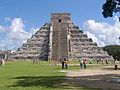
The Temple of Kukulcán (El Castillo)


The Temple of Kukulcán is the most famous building in Chichén Itzá. Kukulcán was a Maya feathered serpent god, similar to the Aztec Quetzalcoatl. The Spanish called this temple El Castillo, meaning "the castle."
This pyramid is about 30 meters (98 feet) tall. It has nine square levels, each about 2.57 meters (8.4 feet) high. A temple sits on top of the pyramid.
The pyramid's sides are about 55.3 meters (181 feet) long at the base. Each of the four sides has a staircase. At the bottom of the main staircase, you can see carved heads of a serpent.

Maya cultures often built new structures over older ones. The Temple of Kukulcán is an example of this. In the 1930s, archaeologists found another temple hidden inside the current pyramid.
Inside this hidden temple, they found a statue and a throne shaped like a jaguar. The jaguar throne was painted red and had spots made of beautiful jade. For a while, visitors could go inside a tunnel to see this hidden temple. However, it was closed to the public in 2006 to protect it.
Around the spring and autumn equinoxes, a special shadow appears. In the late afternoon, the pyramid casts triangular shadows on the staircase. This makes it look like a serpent is slithering down the steps. Many people believe this effect was made on purpose to mark the equinoxes. However, this shadow can be seen for several weeks around the equinoxes, so it doesn't mark a single date.
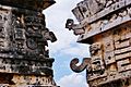
The Great Ball Court

Chichén Itzá has thirteen ballcourts, but the Great Ball Court is the largest and most impressive. It's about 150 meters (490 feet) northwest of El Castillo. It is the biggest and best-preserved ball court in ancient Mesoamerica. It measures 168 by 70 meters (551 by 230 feet).
The long walls on either side of the playing area are 8 meters (26 feet) high. High up on these walls are rings carved with feathered serpents.
At the bottom of the walls are slanted benches with carved pictures of ball players.
At one end of the court is the North Temple, also called the Temple of the Bearded Man. It has detailed carvings inside. At the south end is another, larger temple, but it is mostly in ruins.
Built into the east wall are the Temples of the Jaguar. The Upper Temple of the Jaguar looks out over the ball court. Its entrance has two large columns carved with feathered serpents. Inside, there's a large, damaged mural showing a battle.
The Lower Temple of the Jaguar opens behind the ball court. It has another jaguar throne, similar to the one inside El Castillo. Its outer columns and inner walls are covered with detailed carvings.
Other Structures on the Great North Platform
The Tzompantli, or Skull Platform, shows influence from central Mexico. Unlike other skull platforms, the skulls here were placed vertically.
The Platform of the Eagles and the Jaguars is next to the Great Ballcourt. It mixes Maya and Toltec styles. Its sides are decorated with carvings of eagles and jaguars eating human hearts.
The Platform of Venus is dedicated to the planet Venus. Archaeologists found large stone cones inside it, but their purpose is unknown.
The Temple of the Tables is part of a group of buildings east of El Castillo. Its name comes from altars supported by small carved figures of men.
The Steam Bath is a unique building with a waiting area, a water bath, and a steam room. The steam was created by heated stones.
Sacbe Number One is a paved road that leads to the Sacred Cenote. It is the largest road at Chichén Itzá, about 270 meters (886 feet) long and 9 meters (30 feet) wide.
The Sacred Cenote

The Yucatán Peninsula has no rivers above ground. Instead, it has many natural sinkholes called cenotes. These cenotes show where the underground water is. The Cenote Sagrado is one of the most impressive. It is 60 meters (200 feet) wide and surrounded by steep cliffs. The water is about 27 meters (89 feet) below.
The Sacred Cenote was a very important place for ancient Maya pilgrimages. During dry times, they would make offerings there. Archaeologists have found thousands of objects at the bottom. These include gold, carved jade, pottery, flint, obsidian, and even skeletons of children and men.
The Chultun of Children
In 1967, workers found a small cave system near the Sacred Cenote. It contained the remains of over 100 children, mostly boys aged three to six. DNA tests showed some of them were related, including identical twins. Archaeologists believe these remains were part of a special "ritual event." While there's no clear sign of sacrifice, some researchers think it might have been part of the ritual.
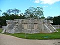
The Temple of the Warriors


The Temple of the Warriors is a large pyramid with rows of carved columns. These columns show pictures of warriors. This complex is similar to a temple in the Toltec capital of Tula, suggesting cultural connections. However, the one at Chichén Itzá is much larger. At the top of the pyramid, near the temple entrance, is a statue called a Chac Mool.
This temple was built over an older structure called The Temple of the Chac Mool. The Carnegie Institution worked on restoring this building from 1925 to 1928. They found murals inside that showed battle scenes. Some images even hint at possible contact with Viking sailors, which is a fun mystery for experts to discuss!
The Group of a Thousand Columns
South of the Temple of Warriors are many columns that once supported a large roof. These columns are in three sections. Some have carvings of soldiers.
One section, the northeast group, covers a clever engineering trick. It has a channel that collects rainwater from the complex. This water is then funneled about 40 meters (130 feet) away to an old cenote.
South of these columns are three smaller buildings. The Temple of the Carved Columns has a gallery and an altar with a Chac Mool. Its columns have rich carvings of people, gods, animals, and serpents.
The Temple of the Small Tables is an unrestored mound. Thompson's Temple has two levels with carvings of jaguars (balam in Maya) and glyphs of the Maya god Kahuil.
El Mercado
This square building is at the southern end of the Temple of Warriors complex. Early explorers thought it was a marketplace because of a stone shelf inside. Today, archaeologists believe it was used for ceremonies, not for selling goods.
Osario Group


South of the Great North Platform is a smaller area with important buildings. Many of these seem to face the second-largest cenote in Chichén Itzá, called Xtoloc.
The Osario itself is a pyramid temple, smaller than El Castillo. It also has four sides with staircases. On top, there's an opening that leads to a natural cave 12 meters (39 feet) below. Edward H. Thompson explored this cave and found skeletons and jade beads. He called the structure "The High Priests' Temple." Today, archaeologists don't think it was a tomb for priests.
The Temple of Xtoloc is a recently restored temple near the Osario Platform. It overlooks the Xtoloc cenote, named after the Maya word for iguana. The temple has carved pillars showing people, plants, birds, and mythical scenes.
Between the Xtoloc temple and the Osario are several aligned structures. These include another Platform of Venus, the Platform of the Tombs, and a small, round building.
South of the Osario are two small buildings. Archaeologists believe these were homes for important people. They are called the House of the Metates and the House of the Mestizas.
Casa Colorada Group
South of the Osario Group is another small platform with some of the oldest buildings in Chichén Itzá.

The Casa Colorada (Spanish for "Red House") is one of the best-preserved buildings. It still had a lot of red paint when explorers first saw it in the 1800s. Its Maya name, Chichanchob, might mean "small holes." Inside, there are carved hieroglyphs that mention rulers and a Maya date from 869 AD. This is one of the oldest dates found in Chichén Itzá.
In 2009, INAH restored a small ball court next to the Casa Colorada.
While the Casa Colorada is well-preserved, most other buildings in this group are just mounds. One half-standing building is called La Casa del Venado (House of the Deer). Local Maya people have used this name for a long time.
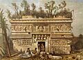
Central Group


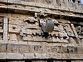
Las Monjas is a very important group of buildings. It was built in the Puuc architectural style. The Spanish called it "The Nuns" or "The Nunnery," but it was actually a government palace. East of it is a small temple called La Iglesia ("The Church"), decorated with many masks.
The Las Monjas group has many hieroglyphic texts from the Late to Terminal Classic periods. These texts often mention a ruler named Kʼakʼupakal.
El Caracol ("The Snail") is north of Las Monjas. It's a round building on a large square platform. It gets its name from the spiral staircase inside. Because of its unique round shape and how its doors and windows line up, experts think it was an ancient observatory. It was likely used to track astronomical events, especially the path of the planet Venus.
Akab Dzib is east of the Caracol. Its name means "Dark Writing" in Yucatec Mayan, referring to mysterious carvings. An older name for the building was Wa(k)wak Puh Ak Na, meaning "the flat house with many chambers." It was likely the home of Chichén Itzá's administrator.
INAH finished restoring the building in 2007. It's about 6 meters (20 feet) high, 50 meters (160 feet) long, and 15 meters (49 feet) wide. The western side has seven doorways. The eastern side has four doorways and a large staircase leading to the roof. This was probably the front of the building, looking out over a dry cenote.
The southern end has one entrance. Inside, on the opposite wall, is another doorway. Above this doorway are intricately carved glyphs—the "mysterious writing." Below the doorway, there's a carved panel of a seated figure with more glyphs. Inside one room, near the ceiling, you can see a painted handprint.
Old Chichen

Old Chichen (or Chichén Viejo in Spanish) is a group of structures south of the main site. Most of the Puuc-style buildings are found here. This area includes the Initial Series Group, the Platform of the Great Turtle, the Temple of the Owls, and the Temple of the Monkeys.
This part of the site has been closed to visitors for many years. Archaeologists have been working on excavations and restorations. It is expected to reopen to visitors in 2024.
The Caves of Balankanche

About 4 kilometers (2.5 miles) southeast of Chichén Itzá are sacred caves called Balankanche. Inside these caves, you can see many ancient pottery pieces and idols. They are still in the same spots where the Maya left them long ago.
These caves have been known for a long time. Explorers visited them in the early 1900s. In 1959, a local guide found a hidden wall in the cave. Behind it was a large network of caves with many undisturbed archaeological treasures. These included pottery, stone censers, tools, and jewelry.
INAH turned the cave into an underground museum. After cataloging the objects, they were put back in their original places. This way, visitors can see them exactly as they were found.
The Great Museum of Chichén Itzá
The Great Museum of Chichén Itzá is a new archaeological museum. It opened on February 28, 2024, in the town of Pisté. It is part of the Visitor Attention Center (Catvi). The museum holds over 1,000 artifacts. These include 400 original pieces from various places and new discoveries from the Maya Train project.
The museum takes visitors on a journey through Chichén Itzá's history. It has 14 themed areas. A special highlight is the Sacred Cenote Room, which uses multimedia to recreate this ceremonial site. You can also see sculptures of Chac Mool and a stone table with carvings of captives. Offerings found in the ancient Maya roads (sacbeo'ob) are also on display.
The museum has 3,400 square meters (36,600 square feet) of space. It includes exhibition halls, workshops, and conference areas. There's also a food center that promotes the Maya language. Its location makes it easy for tourists arriving at the Chichén Itzá railway station of the Maya Train to visit.
-
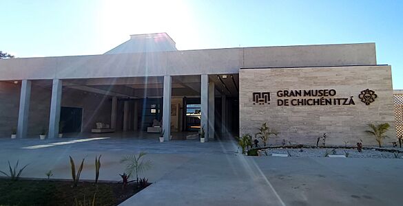
Entrance of the Great Museum of Chichén Itzá.
-
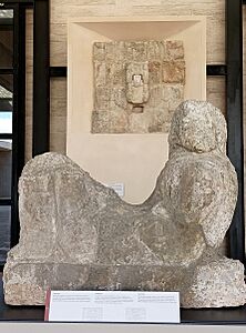
Chac Mool sculpture at the entrance of the museum.


Visiting Chichén Itzá Today
.jpg)
Chichén Itzá is one of Mexico's most popular archaeological sites. In 2017, over 2.1 million people visited it.
Tourism has been important for Chichén Itzá for over a century. John Lloyd Stephens' book made the Maya Yucatán famous. This inspired many people to visit Chichén Itzá.
In the early 1900s, a hotel was planned near the ruins. In 1923, a highway to Chichén Itzá was officially opened. This made it easier for people to visit.
Fernando Barbachano Peon started Yucatán's first official tourism business in the 1920s. He bought land near Chichén Itzá for a hotel. In 1930, the Mayaland Hotel opened. Later, Barbachano Peon bought all of the Hacienda Chichén, including the ruins.
In 1972, Mexico passed a law that made all pre-Columbian monuments, including Chichén Itzá, federal property. This meant the government owned and protected them. With the growth of tourist resorts like Cancún, more visitors came to Chichén Itzá.
In the 1980s, many visitors started coming to Chichén Itzá for the spring equinox. Thousands gather to see the light-and-shadow effect on the Temple of Kukulcán. This makes it look like the feathered serpent is crawling down the pyramid. Tour guides also show a cool sound effect: if you clap your hands in front of El Castillo, the echo sounds like a bird's chirp, similar to a quetzal.
Chichén Itzá is a World Heritage Site recognized by UNESCO. It is the second most visited archaeological site in Mexico. Many visitors come on day trips from popular resorts like Cancún.
In 2007, Chichén Itzá's Temple of Kukulcán (El Castillo) was named one of the New Seven Wonders of the World. This brought even more attention to the site. This publicity also led to a debate about who owned the land. On March 29, 2010, the state of Yucatán bought the land where the main monuments stand.
INAH, which manages the site, has closed some monuments to public access. Visitors can walk around them, but they can no longer climb them or go inside. Climbing El Castillo was stopped after a visitor fell in 2006.
Images for kids
-
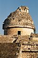
El Caracol, observatory of Chichen Itza
-

Temple of the Warriors in 1986 - The Temple of the Big Tables, immediately to the left, was unrestored at that time
-
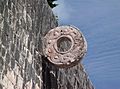
Stone Ring located 9 meters (30 feet) above the floor of the Great Ballcourt
-
Platform of Venus in the Great Plaza
-
Kukulcán pyramid
-
Mosaic mask on the western face of La Iglesia
-
Elaborate mosaic masks
-

A feathered serpent sculpture at the base of one of the stairways of Kukulcán (El Castillo)
-
Las Monjas (Chichen Itza) in 1843 by Frederick Catherwood.


See also
 In Spanish: Chichén Itzá para niños
- Chichén Itzá railway station
- Asteroid 100456 Chichen Itza
- List of archeoastronomical sites sorted by country
- List of Mesoamerican pyramids
- Tikal
- Uxmal
