
Cenote facts for kids


A cenote is a natural pit or sinkhole. It forms when limestone rock collapses, showing the groundwater underneath. Cenotes are very common in the Yucatán Peninsula of Mexico. The ancient Maya people sometimes used them for important offerings.
The word "cenote" comes from the Yucatec Maya word ts'onot. This word means any place with easy access to groundwater. Cenotes are often found in warm areas, especially on islands, coastlines, and places with young limestone.
Contents
What is a Cenote?
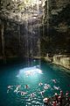
Cenotes are natural openings that connect to underground water. Some cenotes are large open pools, like those at Chichén Itzá in Mexico. These can be many meters wide. However, most cenotes are smaller and hidden, and they might not even have water showing on the surface. Similar features in places like Cuba and Australia are also called cenotes or sinkholes.
The water in cenotes is usually very clear. This is because it comes from rainwater that slowly filters through the ground. This filtering removes most tiny particles. The water flow inside a cenote can be very slow. But in some cenotes, which are parts of collapsed cave systems, the water can flow much faster. Many cave divers visit cenotes around the world. They explore and map the huge underwater cave systems connected to them. Some of these systems are over 100 kilometers (60 miles) long!
How Cenotes Form

.jpg)
Cenotes form when rock dissolves and creates an empty space underground. This space might be part of an active cave system. Later, the roof of this space can collapse. The fallen rock then slowly dissolves in the water below. This creates more space for more rock to fall. The collapse happens faster when the water table is below the cave ceiling. This is because the water no longer supports the rock above.
Some cenotes collapse completely, forming an open pool of water. Others only collapse partly, with some rock hanging over the water. The most common cenotes look like small, round ponds. They can be tens of meters wide with steep sides. But many cenotes need you to bend or crawl to reach the water.
Different Kinds of Cenotes

In 1936, a simple way to classify cenotes was created based on their shape:
- Jug or pit cenotes (Cenotes-cántaro): These have a surface opening that is narrower than the water body below.
- Cylinder cenotes (Cenotes-cilíndricos): These have straight, vertical walls.
- Basin cenotes (Cenotes-aguadas): These have shallow water basins.
- Cave cenotes (grutas): These have a horizontal entrance and some dry areas.
This classification was based on what could be seen above the water. It didn't fully show how cenotes formed or their connection to the flooded cave networks. These underwater caves were only discovered much later, starting in the 1980s, when cave diving began.
Cave Diving in Cenotes

Cenotes are very popular with cave divers. Many groups work to explore and map these amazing underwater systems. For example, the Quintana Roo Speleological Survey keeps a list of the longest and deepest water-filled and dry caves in that area of Mexico.
Images for kids
-
The cenote at Hubiku, Yucatan.
-

A geological drawing of Cenote Ik Kil.
-

Scuba diving in a cenote.


See also
 In Spanish: Cenote para niños
