
Caracol facts for kids

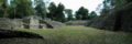
View from atop of Caracol
|
|

Location in Mesoamerica

Location in Belize
|
|
| Location | Cayo District, Belize |
|---|---|
| Region | Cayo District |
| Coordinates | 16°45′50″N 89°7′3″W / 16.76389°N 89.11750°W |
| History | |
| Founded | 1200 BCE |
| Periods | Preclassic to Postclassic |
| Cultures | Maya civilization |
Caracol is a huge ancient Maya city. It is found in the Cayo District of Belize. This amazing site is about 40 kilometers south of Xunantunich. It sits on the Vaca Plateau, about 500 meters above sea level.
For a long time, people thought Caracol was a smaller Maya center. But now we know it was one of the most important cities. It was a major political hub in the Maya Lowlands. Caracol covered about 200 square kilometers. This area is much bigger than modern-day Belize City. It also had more than twice the population of Belize City today.
Contents
What Does Caracol Mean?
The name "Caracol" is a modern one. It comes from the Spanish word for "snail" or "shell." It also means spiral or winding. This name was likely chosen because of the winding road that leads to the ancient city.
Finding the Lost City
A logger named Rosa Mai first found the site in 1937. He was looking for mahogany trees. Mai told the archaeological commission in British Honduras, which is now Belize.
In 1938, A. H. Anderson, the archaeological commissioner, visited Caracol. He was with his colleague H. B. Jex. Anderson was the one who gave the site its modern name. They did some early surveys and found 9 carved stone monuments. They also looked at the buildings in the A Group Plaza. Later, Anderson and Linton Satterthwaite found 40 more stone monuments.
Digging Up Caracol's Secrets
Archaeologists have been studying Caracol for many years. Linton Satterthwaite from the University of Pennsylvania Museum of Archaeology and Anthropology worked there from 1950 to 1953. He focused on finding and documenting monuments. He even moved some large stone carvings, called stelae and altars, to a museum in Philadelphia. His work helped create an early map of the city's center.
Since 1985, the Caracol Archaeological Project has been ongoing every year. It is led by Arlen and Diane Chase. They have learned a lot about the city's history and how it grew. In 2009, they used a special aircraft with LiDAR technology. This allowed them to quickly map 200 square kilometers of the site. They found many new causeways and thousands of ancient homes.
Today, you can reach Caracol by a paved road. This road connects to the Western Highway.
Caana: The Sky-Palace

The largest building at Caracol is called Caana. Its name means "sky-palace." It is the tallest man-made structure in Belize. Caana stands about 43 meters (141 feet) tall. It was rebuilt by Lord Water, an important ruler. Many tombs were found inside its structures.
How Many People Lived in Caracol?
Caracol was one of the biggest ancient Maya cities. It had about 267 buildings per square kilometer. This is much more than at Tikal, another famous Maya city. The city covered about 200 square kilometers. Experts believe its population was over 100,000 people. Some estimates suggest it might have reached 180,000 people. People lived along the many ancient roads, called causeways, that spread out from the city center.
Caracol's Long History
The Caracol area was first settled around 1200 BC. But the main city center started around 650 BC. It was active until about AD 950. Caracol has 53 carved stone monuments. These include 25 stelae (tall carved stones) and 28 altars (round carved stones). Over 250 burials and 200 hidden offerings have also been found.
By the Early Classic period (AD 250-550), Caracol was part of a large trade network. This helped create a strong economy in the region. The Caracol royal family officially began in AD 331 with Te’ K’ab Chaak.
Wars with Tikal and Naranjo
Caracol was once a smaller ally of Tikal, a powerful city 76 kilometers away. But Tikal's power began to weaken around the mid-500s. In AD 553, Lord Water (Yajaw Te' K'inich II) became the ruler of Caracol. He was under Tikal's influence at first.
In AD 556, Tikal attacked Caracol in a "ch’ak" (axe) war. But Lord Water fought back. In AD 562, he led a "star war" against Tikal. Star wars were serious conflicts, often linked to Venus. This war defeated Tikal's ruler, Lord Wak Chan K’awiil. This caused a long break in Tikal's growth. During this time, Caracol grew much stronger and more successful.
Lord Water's son, K’an II, became ruler in AD 618. He was a very successful leader. He ruled for 40 years, from AD 618 to 658. K’an II expanded the causeway system and saw the city's population grow. He also attacked Naranjo, another Maya city, several times. He even sacrificed Naranjo's king in AD 628.
A Time of Growth
After the wars with Tikal and Naranjo, Caracol experienced a building boom. The city remained very strong and united. During this time, Caracol had a unique way of burying people. They often had multiple burials in special rooms. K’an II ordered more monuments to be built than any other ruler. This period is known as Caracol's "golden age."
Later, Caracol was defeated in a star war by Naranjo in AD 680. This led to a period where fewer hieroglyphic texts were created. However, the city still seemed to be doing well. Around AD 800, K’inich Joy K'awiil became ruler. He captured eight enemies in battle. Caana, the sky-palace, was also renovated during this time.
The End of Caracol
Caracol seemed to handle the start of the Classic Maya collapse better than some other cities. For a while, many people, not just the rich, had access to fancy goods. But later, the wealthy started to have their own special items. These items were no longer available to everyone.
The last recorded date at Caracol is AD 859. Caana was abandoned around AD 900. Other buildings were used a bit longer. The very last building, Structure A6, was abandoned in AD 1050. This marks the complete end of the city of Caracol.
Important Rulers of Caracol
Many rulers led Caracol throughout its history. Here are some of the most important ones:
- Te' K'ab Chaak (331–349 AD): He is considered the founder of Caracol's royal family.
- Yajaw Te' K'inich I (484–514 AD): He celebrated important events and had monuments built.
- K'an I (531–534 AD): Son of Yajaw Te' K'inich I.
- Yajaw Te' K'inich II (553–593 AD), also known as Lord Water: He famously defeated Tikal in a star war, making Caracol much more powerful.
- Knot Ajaw (599–613 AD): Son of Lord Water.
- K'an II (618–658 AD): He was the most successful ruler. He expanded the city and its population. He also led wars against Naranjo.
- K'ahk' Ujol K'inich II (658–680 AD): Caracol was defeated by Naranjo during his rule.
- K'inich Joy K'awiil (798 AD): He helped revive the city and captured enemies.
- K'inich Toob'il Yoaat (810–830 AD): He tried to improve relations with Ucanal.
- Ruler XIII (859 AD): The last known ruler of Caracol.
Other Maya Sites Nearby
Other interesting Maya sites in the Cayo district include Xunantunich, Cahal Pech, and Chaa Creek.
Images for kids
-
The southern acropolis, showing ancient homes.
- 1937
- Rosa Mai discovers site
- 1938
- A. H. Anderson initially visits Caracol
- 1950-1953
- Linton Satterthwaite and the University Museum conducts investigations focusing on recording monuments, and makes a limited map
- 1956-1958
- A. H. Anderson returns to Caracol and excavates in the A Group and South Acropolis
- 1980
- Paul Healy of Trent University investigates agricultural terraces and notes unusually high settlement density
- 1985
- Caracol Archaeological Project begins; Structures A6, and B20 investigated
- 1986
- Discovery of Altar 21 leading to the reexamination of the “Classic hiatus”; Painted Tomb of a royal woman found at Caana, dated to AD 634. Conchita and Pajaro-Ramonal Causeways located.
- 1987
- Initiation of settlement research; Causeway system discovered
- 1988
- Southeast settlement research – Demonstrates the increase in population after the Tikal-Naranjo wars
- 1989
- Southeast sector settlement work continues; Agricultural fields, housing, and causeways demonstrated to be post-war phenomena. Construction on Caana demonstrated to be post-AD 800
- 1990
- Structures A2, A7, and A8 excavated; Early Classic construction of South Acropolis found.
- 1991
- Exploration and mapping of causeways. Ceiba and Retiro Termini located. Structure A6 excavated; found stone box cache with jade mask and mercury. Intact stucco frieze found on earlier construction of Caana. Belize government declares the Caracol area a national park.
- 1992
- Ruler’s tomb discovered in the South Acropolis; royal tombs found in the Central Acropolis. Belize government constructs road to the site
- 1993
- Investigations on Canna; royal tomb located in Structure B20; ritual deposits located in B19. Hieroglyphic texts found in non-elite contexts
- 1994-1995
- Northeast sector investigated to determine settlement density and dating; mapping and reconnaissance indicate no settlement drop-off for 6 km (3.7 mi), and the radius of the site determined to be 10 km (6.2 mi) from the Cahal Pichik, Ceiba, Retiro, and Hatzcap Ceel Causeways and Termini
- 1996
- Central 9 square kilometers of the site mapped. Preclassic shrine dated to 100 BC found in front of Structure B34 of the Northeast Acropolis
- 1997
- Mapping of central 16 km2 (6.2 sq mi) completed. Southeast sector residential groups with open, collapsed, and looted tombs explored
- 1998
- Basal architecture of Structures A1, A3, and A8 explored. Mapping recorded the Retiro and Ceiba termini and their associated causeways
- 1999
- Basal stairs of Structures A2 and A3 trenched. Residential group immediately north of the center excavated. Mapping recorded an east-west transect 6 km north of the center. Caracol Site Museum opens
- 2000
- Excavations focused on structures within the southwest walled area, and one residential group immediately south of the area. Terraces in the Chaquistero area mapped. Dr. Jaime Awe and the Belize Tourism Development Project (TDP) began “tourist-proofing” Caracol’s buildings
- 2001
- Palace structures of Barrio and Caana excavated in preparation for their stabilization. Terminal Classic trash deposits recovered in Barrio; two elite tombs found at the base of Structure B19
- 2002
- Excavations focused on Structures A13, B28, and F4, as well as the plaza in front of Structure B33. A new Stela was found in front of Structure B28; a stucco text was recovered in association with Structure B19. The materials from the TDP’s excavations of two residential tombs were analyzed
- 2003
- Excavations focused on five smaller buildings adjacent to the South Acropolis in order to determine the presence attached specialists; TDP begins stabilization of the South Acropolis. Four burials and a collapsed Protoclassic chultun were also recovered.
- 2004
- Continued focus on attached specialists; small structures immediately east of Barrio and West of Caana excavated, recovering Terminal Classic line-of-stone buildings and three Early Classic interments. TDP concluded their work
- 2005
- Investigations focused on locating non-palace Terminal Classic occupation associated with small structures in the center. Excavations of Structure I20 produced late use-related materials and a burial; Structure B59 proved to be of late construction. Structures B40, B42, and B44 showed a series of tombs and caches spanning from the Protoclassic to the Terminal Classic
- 2006
- Investigations of epicentral structures which were utilized within the broad Late and Terminal Classic social and economic system. Excavated structures include A31, the Northwest Acropolis (Structures A61-A69), and the Gateway residential group (Structures B139-143).
- 2007
- Recovery of early caching practices both in the center and in an epicentrally proximate residential group revealed variant caching practices and associated ceremonial activities. These findings raised issues of ritual variability throughout the center and immediately adjacent residential groups. Investigated structures included Structures A16, B7, D2, and I2-I8.
- 2008
- Excavations were undertaken in the Culebras and Palmitas residential groups on either side of the Pajaro-Romonal Causeway to determine whether differential composition of residential complexes existed in close proximity to the center. The causeway running from the center to the Ceiba Terminus was extended and mapped all the way to La Rejolla, a site which exhibited monuments with the Caracol emblem glyph.
- 2009
- The use of LiDAR was introduced to the site and the mapping of 200 square kilometers revealed the presence of eleven new causeways, five new termini, and thousands of residential groups and agricultural terraces. Excavations were also undertaken in the Northeast Acropolis and the Culebras residential group (especially focusing on Structure C20).
- 2010
- Investigations focused on ground-checking the remote sensing data gained from LiDAR in 2009, especially on the location of caves. Excavations focused on Structures F30-F42 of the double plaza complex Alta/Baja Vista, as well as further excavations of the Northeast Acropolis.
See also
 In Spanish: El Caracol (Belice) para niños
