
Belize City facts for kids
Quick facts for kids
Belize City
|
||
|---|---|---|
|
City
|
||
| City of Belize | ||

From top; left to right: St. John's Cathedral, the Government House, the CARICOM Flag Monument, the Bliss Institute, Aerial of Belize City, Princess Hotel and Casino, the Central Bank of Belize, High Court Building and the Swing Bridge
|
||
|
||
| Etymology: From the Belize River, corruption of Balis, word that comes from the Mayan language. | ||
| Nicknames:
The Old Capital, The City
|
||

Belize City
Location in Belize

Belize City
Location in Caribbean

Belize City
Location in Central America

Belize City
Location in North America
.svg)
Belize City
Location in Earth
|
||
| Country | Belize | |
| District | Belize | |
| Settled | 1638 (as a camp) 1650s (as a port) 1783 (as a town) |
|
| Incorporated | 1783 (as capital) 1981 (as a city) |
|
| Founded by | Peter Wallace | |
| Named for | Peter Wallace | |
| Government | ||
| • Type | Mayor–council | |
| • Body | City Council | |
| Area | ||
| • Total | 13.77 sq mi (35.7 km2) | |
| Elevation | 0 ft (0 m) | |
| Population | ||
| • Total | 61,461 | |
| • Density | 4,463/sq mi (1,722/km2) | |
| Demonym(s) | Belizean | |
| Time zone | UTC−6 (GMT-6) | |

Belize City is the biggest city in Belize. It used to be the capital when Belize was called British Honduras. In 2010, about 61,461 people lived there.
The city sits where the Haulover Creek meets the sea. This creek is a branch of the Belize River. The Belize River flows into the Caribbean Sea about 5 miles (8 km) from Belize City. This is along the Philip Goldson Highway.
Belize City is Belize's main port. It is also a major center for money and businesses. Large cruise ships stop outside the port. Smaller boats then take passengers to shore. A big hurricane called Hurricane Hattie almost destroyed the city in October 1961. Because of this, the government moved the capital to Belmopan in 1970.
Contents
History of Belize City
Belize City was started in 1638 by English lumber workers. They called it "Belize Town." Before that, it was a small Maya village named Holzuz.
Belize Town was a great spot for the English. It was by the sea and connected to local rivers. This made it easy to ship out wood like logwood and mahogany. Thousands of African slaves were brought here by the English. They worked hard in the logging industry.
The town was also important for battles. In 1798, the British won the Battle of St. George's Caye here. This battle stopped invaders. Belize Town was also where the local courts and government were until the 1970s. Many historians say that "the capital was the colony." This means the town was the main place where the British controlled the area.
Even today, Belize City is very important. People like George Price started their movements here. Other groups, like the Garifuna and Mestizos, also looked to Belize Town for leadership.
Natural Disasters in Belize City
Belize City has been hit by strong hurricanes. Two big ones were the 1931 hurricane and Hurricane Hattie in 1961. Parts of the city have also burned down in fires. Recent fires happened in 1999 and 2004.
More recently, Hurricane Richard hit in 2010. Hurricane Earl also caused damage in 2016. The city's fire department has worked hard to put out these fires. Belize City can also flood a lot during the rainy season.
Location and City Layout
.jpg)
Belize City stretches along the Western Highway and Northern Highway. It is located near the Haulover Bridge.
The city is split into two main parts. The Northside is bordered by Haulover Creek. It ends in the east at the Fort George area. The Southside goes out to the edges of the city. This part includes the port and downtown. For politics, the city is divided into ten areas called constituencies.
Cityscape of Belize City

Freetown is the westernmost area on the Northside. It has suburbs like Belama and Buttonwood Bay.
Caribbean Shores includes Kings' Park. This is a small area north of Freetown Road. West Landivar is also here. It has two of the University of Belize's campuses.
Pickstock is along the Haulover Creek. It goes up to Barrack Road. St. John's Cathedral is on the south end of Albert Street. This church is the oldest Anglican church in Central America. It is also one of the oldest buildings in Belize. The orange bricks for the church came from Britain on ships. Building started in 1812 and finished in 1820. St. John's is special because it's the only Anglican cathedral outside England where kings were crowned.
Fort George is a very old part of the city. It has Memorial Park and the Baron Bliss Grave. You can also find the Baron Bliss Lighthouse and the Museum of Belize here.
On the Southside, areas like Lake Independence and Port Loyola are home to many residents. Some parts have simple wooden walkways between homes. Albert Street and Regent Street are downtown streets.
Bridges and Waterways

Four bridges connect the different parts of the city. The Swing Bridge is at Market Square. The Belchina Bascule Bridge is near Douglas Jones Street. The Belcan Bridge links Central American Boulevard to the Northern Highway. A new fourth bridge connects Fabers' Road to the northwest suburbs. Many smaller bridges also connect individual streets.
Belize City has three main canals. They are Haulover Creek, Burdon Canal, and Collet Canal. All of them run through the Southside of the city.
Climate in Belize City
Belize City has a tropical monsoon climate. This means it is very warm and humid all year. The city has a long wet season from May to February. There is a short dry season in March and April.
Even during the dry season, Belize City gets some rain. March is usually the driest month. The average monthly temperatures stay about the same. They range from 24 to 28 degrees Celsius (75 to 82 degrees Fahrenheit).
| Climate data for Belize City (Philip S. W. Goldson International Airport) 1991–2020, extremes 1866–present | |||||||||||||
|---|---|---|---|---|---|---|---|---|---|---|---|---|---|
| Month | Jan | Feb | Mar | Apr | May | Jun | Jul | Aug | Sep | Oct | Nov | Dec | Year |
| Record high °C (°F) | 34.2 (93.6) |
34.7 (94.5) |
37.3 (99.1) |
37.7 (99.9) |
37.0 (98.6) |
35.7 (96.3) |
33.8 (92.8) |
35.0 (95.0) |
35.3 (95.5) |
34.0 (93.2) |
33.3 (91.9) |
34.0 (93.2) |
37.7 (99.9) |
| Mean daily maximum °C (°F) | 27.9 (82.2) |
28.8 (83.8) |
29.8 (85.6) |
31.2 (88.2) |
31.9 (89.4) |
31.7 (89.1) |
31.5 (88.7) |
31.8 (89.2) |
31.8 (89.2) |
30.6 (87.1) |
29.2 (84.6) |
28.3 (82.9) |
30.4 (86.7) |
| Daily mean °C (°F) | 24.3 (75.7) |
25.2 (77.4) |
26.1 (79.0) |
27.7 (81.9) |
28.5 (83.3) |
28.7 (83.7) |
28.4 (83.1) |
28.5 (83.3) |
28.3 (82.9) |
27.2 (81.0) |
25.6 (78.1) |
24.7 (76.5) |
26.9 (80.4) |
| Mean daily minimum °C (°F) | 20.6 (69.1) |
21.5 (70.7) |
22.4 (72.3) |
24.2 (75.6) |
25.2 (77.4) |
25.7 (78.3) |
25.3 (77.5) |
25.3 (77.5) |
24.9 (76.8) |
23.9 (75.0) |
22.0 (71.6) |
21.2 (70.2) |
23.5 (74.3) |
| Record low °C (°F) | 11.0 (51.8) |
11.5 (52.7) |
10.9 (51.6) |
15.0 (59.0) |
19.0 (66.2) |
20.8 (69.4) |
20.7 (69.3) |
21.0 (69.8) |
19.3 (66.7) |
16.1 (61.0) |
14.4 (57.9) |
12.0 (53.6) |
10.9 (51.6) |
| Average rainfall mm (inches) | 141.4 (5.57) |
64.7 (2.55) |
41.0 (1.61) |
58.0 (2.28) |
131.8 (5.19) |
236.4 (9.31) |
180.2 (7.09) |
195.0 (7.68) |
229.8 (9.05) |
305.5 (12.03) |
235.8 (9.28) |
150.9 (5.94) |
1,970.5 (77.58) |
| Average rainy days (≥ 1.0 mm) | 10 | 6 | 4 | 4 | 7 | 12 | 14 | 14 | 16 | 16 | 13 | 12 | 128 |
| Average relative humidity (%) | 83 | 82 | 79 | 77 | 79 | 82 | 83 | 84 | 84 | 83 | 84 | 84 | 82 |
| Mean monthly sunshine hours | 199 | 203 | 239 | 256 | 257 | 197 | 226 | 237 | 178 | 196 | 180 | 190 | 2,558 |
| Source 1: National Meteorological Service of Belize, Meteo Climat (record highs and lows) | |||||||||||||
| Source 2: Deutscher Wetterdienst (sun, 1961–1990, humidity 1975–1989) | |||||||||||||
Schools and Learning
Belize City has more schools than any other city in Belize. Many children in the city go to high school.
On the Northside, there are three schools just for one gender. Saint John's College is for boys. Saint Catherine's Academy and Pallotti High School are for girls. One school on the Southside, Sadie Vernon Technical, used to be only for girls. It became coed (for both boys and girls) in 2005.
There are also three private schools in Belize City. These are Belize Elementary School, Belize High School, and Hummingbird Elementary School.
Culture and Events
Belize City's culture is much like other Caribbean capital cities. It is always busy during the day. There is a lot of activity, as you would expect in a city of over 70,000 people.
Some important cultural events happen here. These include Garifuna Settlement Day on November 19. The Belize City Carnival is in September. Baron Bliss Day is celebrated on March 9.
The city has several museums. You can visit the Bliss Institute, the Image Factory Art Foundation and Gallery, and the Maritime Museum. There is also the Museum of Belize. An annual Street Art Festival takes place too.
Economy and Trade
Most people in Belize City work in offices downtown. Others sell goods on the streets. The city has branches of all the main banks in Belize. It also has the Central Bank. Most insurance centers and marketplaces are found here.
Belize City is a central point for travel. This includes travel by air, sea, and road.
Port of Belize
The city is home to the Port of Belize. This is the main port facility for the entire country.
Getting Around
Belize City might get new railway lines in the future. These lines would go southwest to Spanish Lookout through Belmopan. They would also go north to Orange Walk Town. Studies are being done to see if this is possible.
Air Travel
The city has two airports. Philip S. W. Goldson International Airport is in Ladyville, northwest of the city. There is also the Belize City Municipal Airport, which is inside the city itself.
Sister Cities
Belize City has "sister city" relationships with other cities around the world:
 Greensburg, United States
- Ann Arbor, United States
- Evanston, United States
 Kaohsiung, Taiwan
 Yeosu, South Korea
- Prairie View, United States
Notable Residents
- Moses Michael Levi Barrow (born Jamal Michael Barrow; 1978), also known as Shyne, is a Belizean rapper and politician.
- Isaiah Emmanuel Morter
Images for kids
-
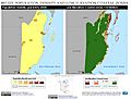
Belize population density and low elevation coastal zones.
-

Belize City, circa 1914.
-
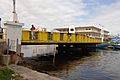
The Swing Bridge in Belize City.
-
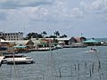
Belize Litoral.

See also
 In Spanish: Ciudad de Belice para niños
