Lake Texcoco facts for kids
Quick facts for kids Lake Texcoco |
|
|---|---|
 |
|
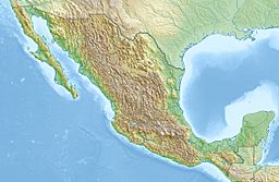
| Location | Central Mexico |
| Coordinates | 19°25′10″N 99°08′00″W / 19.41944°N 99.13333°W |
| Type | Former pluvial and paleo lake |
| Surface area | 2,100 square miles (5,400 km2) |
| Max. depth | over 500 feet (150 m) |
| Surface elevation | 7,349 feet (2,240 m) |
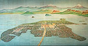
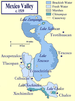
Lake Texcoco (Spanish: Lago de Texcoco) was a large natural lake in the Valley of Mexico. It is most famous as the place where the Aztec people built their amazing capital city, Tenochtitlan. This city was located on an island right in the middle of the lake!
After the Spanish arrived, they tried to control the lake's water to prevent floods. Over time, most of the lake was drained away. Today, the area where the lake once was is almost entirely covered by Mexico City, the capital of Mexico.
Draining the lake has caused big problems for the environment and the people living there. The weather and water supply have changed a lot, leading to water shortages. Also, taking too much water from underground has made parts of the city sink. Many unique animals that lived in the lake, like the Axolotl, are now in danger or have disappeared.
Recently, a big project called the Lake Texcoco Ecological Park started. It aims to bring back a large part of the lake's natural environment. This project covers 12,000 hectares and focuses on restoring the ecosystem.
Contents
History of Lake Texcoco
Ancient Lake and Early Life
Long, long ago, between the Pleistocene Ice Age and the last big ice period, Lake Texcoco was huge. It covered the entire Valley of Mexico. About 11,000 years ago, it reached its biggest size, covering about 2,189 square miles (5,670 km²) and being over 500 feet (150 m) deep!
As the climate warmed naturally, the lake's water level dropped. This created several smaller lakes that sometimes connected. In the north, near San Miguel Tocuila, scientists have found many bones of ancient animals from the Ice Age, like Columbian mammoths. This shows that humans were also in the area around 10,000 to 12,000 years ago. The lake is believed to have disappeared and reappeared many times over the last 30,000 years.
First Settlements and Cultures
People started farming around the lake about 7,000 years ago. They learned to live with the lake's changing water levels.
Around 1700 to 1250 BC, small villages began to appear on the northeast side of the lake. By 1250 BC, the Tlatilco culture developed. They built more complex villages and had a clearer social structure. Later, around 800 BC, Cuicuilco became the most powerful city in the Valley of Mexico. They built a famous pyramid. But a volcano called Xitle destroyed Cuicuilco around AD 30. This event might have led to the rise of another great city, Teotihuacan.
After Teotihuacan fell (around AD 600–800), many other city-states grew around the lake. These included Azcapotzalco, Tlacopan, and Culhuacán. They were influenced by the Toltec and Chichimeca people. These cities lived mostly in peace for several centuries. Aztec stories describe this time as a "Golden Age." However, by the year 1300, the Tepanec people from Azcapotzalco started to take control of the area.
Tenochtitlan: The Aztec Capital
The Mexica people, also known as the Aztecs, founded their famous city of Tenochtitlan in 1325. They built it on a small island in the western part of Lake Texcoco.
The Aztecs were very clever engineers. They expanded their city by creating large artificial islands using a system similar to chinampas (floating gardens). To get fresh drinking water, they built a system of dams. These dams separated the salty lake water from the fresh rainwater that flowed into the lake. This also helped them control the lake's water level. The city itself had many channels to manage water flow.
The Aztec ruler Ahuitzotl tried to build a new aqueduct to bring fresh water to Tenochtitlan. But the aqueduct failed, and the city suffered a major flood in 1502.
When Cortés and the Spanish attacked Tenochtitlan in 1521, the dams were destroyed. They were never rebuilt. This meant that flooding became a huge problem for the new Mexico City that the Spanish built on top of Tenochtitlan's ruins.
Geography of the Valley
The Valley of Mexico is like a big bowl, or basin. It sits high up, about 7,336 feet (2,236 meters) above sea level. Lake Texcoco used to cover a large part of this basin. It was the biggest of five main lakes that were all connected. The other lakes were Xaltocan, Zumpango, Chalco, and Xochimilco.
Most of the lake's water came from underground water sources. Fresh water flowed in from springs in Lake Chalco and Xochimilco. Other springs in Zumpango, Xaltocan, and even Texcoco itself provided salty water. During the rainy season (June to September), all the lakes would often join together as one big body of water. In the drier winter months, they would separate into individual lakes. The Aztecs built dikes and causeways to help manage this flow. Lake Texcoco was the lowest of all the lakes, so all the water eventually drained into it.
The Valley of Mexico is a "closed basin," meaning water doesn't flow out to the ocean. Most of the water that falls as rain simply evaporates.
Draining the Lake
Mexico City often suffered from terrible floods. In 1604, the lake flooded the city, and an even worse flood happened in 1607. A man named Enrico Martínez started building a drain to control the lake's level. But in 1629, another huge flood covered most of the city for five years! People debated whether to move the city, but the Spanish decided to keep it where it was.
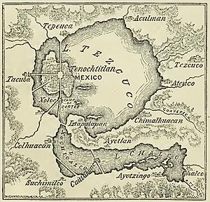
Eventually, the lake was drained using channels and a tunnel that led to the Pánuco River. But even this couldn't stop all the floods, because by then, much of the city was below the water level. Flooding wasn't fully controlled until the 20th century. In 1967, a massive system of tunnels called the Drenaje Profundo ("Deep Drainage System") was built. It carries rainwater out of the basin. Another large tunnel, the eastern discharge tunnel, opened in 2019.
The draining of Lake Texcoco had huge environmental effects. Parts of the valley became very dry, and even today, Mexico City struggles with a lack of water. Because too much water is being taken from underground, Mexico City has sunk about 33 feet (10 meters) in the last century! Also, since the city is built on soft lake sediments, it is very vulnerable to damage during earthquakes, like the big one in 1985.
Today, the term "Texcoco Lake" usually refers to a large area of salt marshes about 4 miles (6.4 km) east of Mexico City. This area covers part of the old lake bed. There are also small parts of the original lakes left, like in Xochimilco, Chalco, and Zumpango.
Many animal species that once lived in the lake are now extinct or endangered, such as the unique axolotl salamander. The modern Texcoco Lake area has a high salt content. A Mexican company, "Sosa Texcoco S.A," even uses an 800-hectare solar evaporator called El Caracol to process the salt.
Restoration and Conservation Efforts
Lake Texcoco Ecological Park
After plans for a new airport in the area were cancelled, the government started a big project to restore a significant part of the lake. This project is called the Lake Texcoco Ecological Park. It aims to create 12,000 hectares of public space and restore the natural environment. This helps bring back some of the important ecosystems that were lost when the lake was drained.
See also
 In Spanish: Lago de Texcoco para niños
 | Georgia Louise Harris Brown |
 | Julian Abele |
 | Norma Merrick Sklarek |
 | William Sidney Pittman |


