Pico de Orizaba facts for kids
Quick facts for kids Pico de Orizaba |
|
|---|---|
 |
|
| Highest point | |
| Elevation | 5,636 m (18,491 ft) |
| Prominence | 4,922 m (16,148 ft) |
| Parent peak | Mount Logan |
| Listing |
|
| Geography | |
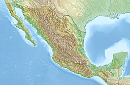
| Location | Veracruz, Mexico |
| Geology | |
| Mountain type | Stratovolcano |
| Volcanic arc/belt | Trans-Mexican Volcanic Belt |
| Last eruption | 1846 |
| Climbing | |
| First ascent | 1848 by F. Maynard & William F. Raynolds |
| Easiest route | moderate snow/ice climb |
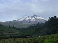
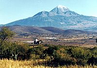
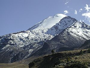
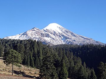
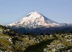
Pico de Orizaba, also known as Citlaltépetl, is a huge, sleeping volcano. Its name in Nahuatl means "Star Mountain" (from citlal(in) = star, and tepētl = mountain). It is the highest mountain in Mexico. It's also the third highest peak in North America, after Denali in Alaska and Mount Logan in Canada. Pico de Orizaba is the tallest volcano in North America too!
This giant mountain stands 5,636 metres (18,491 ft) (about 18,491 feet) above sea level. You can find it at the eastern end of the Trans-Mexican Volcanic Belt, right on the border between the states of Veracruz and Puebla. The volcano is currently sleeping, not completely "extinct," meaning it could wake up again. Its last eruption was in the 1800s. It's the second most prominent (meaning it stands out a lot from the land around it) volcanic peak in the world, only after Mount Kilimanjaro in Africa.
Contents
What's in a Name?
Pico de Orizaba gets its Spanish name because it looks over the valley and city of Orizaba. Long ago, during the time of Spanish rule, people also called it Cerro de San Andrés. This was because of a nearby town called San Andrés Chalchicomula at its base.
Its Nahuatl name, Citlaltépetl, means "Star Mountain." People think it got this name because its snow-covered top can be seen from hundreds of kilometers away, shining like a star. However, local Nahuatl speakers in the Orizaba area call it Istaktepetl, which means 'White Mountain'.
There was also a third name, Poyauhtecatl. This name means "the one that colors or illuminates." The Tlaxcaltecs, an ancient group, gave it this name to remember their lost homeland.
How Tall is Pico de Orizaba?
The peak of Citlaltépetl rises very high, reaching 5,636 m (18,491 ft) (about 18,491 feet) above sea level. It stands out a lot from the land around it, with a prominence of 4,922 m (16,148 ft). This makes it the highest peak in Mexico and the tallest volcano in North America. It's also the third highest peak in North America overall.
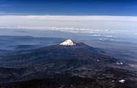
Pico de Orizaba is ranked as the 7th most prominent mountain in the world. It's the second most prominent volcanic peak globally, after Mount Kilimanjaro. It's also the 16th most isolated peak in the world. The mountain is about 110 km (68 mi) (68 miles) west of the port of Veracruz. Its peak is so tall that ships in the Gulf of Mexico can see it as they approach the port. At sunrise, the sun's rays hit Pico de Orizaba while Veracruz is still in shadow.
The volcano's shape is not perfectly even. The eastern side is the steepest, while the northwestern side is more gentle. The gentle slopes on the northwestern side allow for large glaciers. This is also the most common path for climbers to reach the top.
Glaciers of Pico de Orizaba
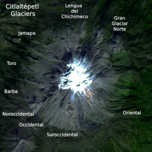
Pico de Orizaba is one of only three volcanoes in Mexico that still have glaciers. It is home to Mexico's largest glacier, called Gran Glaciar Norte. Orizaba has nine known glaciers in total. These include Gran Glaciar Norte, Jamapa, and Glaciar Oriental.
Snow on the south and southeast sides of the volcano melts quickly because of the sun. But on the northwest and north sides, it's colder, allowing glaciers to form and grow. The way the sun hits these sides and how wind moves snow helps snow build up constantly. This snow feeds the glaciers that flow down the mountain.
On the north side, the Gran Glaciar Norte fills a long, high basin. It is the source for seven smaller glaciers that branch off. The main glacier stretches 3.5 km (2.2 mi) (about 2.2 miles) north from the crater rim. It covers an area of about 9.08 km2 (3.51 sq mi) (about 3.5 square miles). It goes from 5,650 m (18,540 ft) (18,537 feet) down to about 5,000 m (16,000 ft) (16,404 feet). Most cracks in the ice, called crevasses, show the ice is about 50 m (160 ft) (164 feet) thick.
Below 5,000 m (16,000 ft) on the north side, the Jamapa glacier extends another 2 km (1.2 mi) (1.2 miles) to the northwest. The most noticeable glacier is Glaciar de Jamapa. It leaves Gran Glaciar Norte at about 4,975 m (16,322 ft) (16,322 feet). After 2 km (1.2 mi), it splits into two smaller parts that end at 4,650 m (15,260 ft) (15,256 feet) and 4,640 m (15,220 ft) (15,223 feet).
On the west side of Gran Glaciar Norte, there are five more glaciers. Glaciar del Toro and Glaciar de la Barba are hanging glaciers that reach the tops of lava steps. Glaciar Noroccidental is a small glacier about 300 m (980 ft) (984 feet) long. Glaciar Occidental is a steep glacier about 1 km (0.62 mi) (0.6 miles) long. Glaciar Suroccidental is 1.6 km (0.99 mi) (1 mile) long.
East of the summit, there is a separate steep glacier called Glaciar Oriental. It is 1.2 km (0.75 mi) (0.75 miles) long and flows down the mountain from about 5,600 to 5,070 m (18,370 to 16,630 ft) (18,373 to 16,634 feet). This glacier has many crevasses and ice towers, making it the hardest to climb. In 1958, Glaciar Oriental covered about 420,000 m2 (4,500,000 sq ft) (4.5 million square feet). The total area of glaciers on Citlaltépetl is about 9.5 km2 (3.7 sq mi) (3.7 square miles).
Mountain Weather
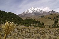
The weather on Pico de Orizaba changes a lot. This is because of its height and the winds. Since it's so tall and rugged, the volcano has many different small climates. The plants growing on it also change a lot. You can find tropical plants at lower parts on the eastern side. Higher up, you'll see alpine forests.
A lot of rain falls on the eastern side of the volcano. This is because warm, moist air from the Gulf of Mexico rises and cools, forming clouds and rain. This eastern side is often covered by fog and low clouds. The climate here goes from tropical at lower heights to subtropical highland higher up. It has mild temperature changes and about 1,600 mm (63 in) (63 inches) of rain each year.
Subtropical climates are found between 2,200–3,200 m (7,200–10,500 ft) (7,200-10,500 feet) above sea level. It rains regularly all year here. In autumn and winter, it often freezes and has light snow. However, snow on the south and southeast sides melts quickly due to the sun. The northern side has a subtropical highland climate. The southern side is mostly humid subtropical, with the warmest temperatures in April.
On the western side, winds create a drier area, like a rain shadow. This means it gets less rain, especially below 2,600 m (8,500 ft) (8,500 feet). Most of this area is semi-dry with mild to warm temperatures. It gets about 550 mm (22 in) (22 inches) of rain each year. Here, you'll mostly see grass and shrubs.
Between 3,200–4,300 m (10,500–14,100 ft) (10,500-14,100 feet), the temperatures are usually between 2 to 5 °C (36 to 41 °F) (36-41°F). Here, a cold, subarctic climate is common. Above 4,300 m (14,100 ft) (14,100 feet), with an average low of −2 °C (28 °F) (28°F), it's like an alpine tundra. Heavy snowfalls and blizzards happen often throughout the year. Snow on the south and southeast melts, but it stays on the north and northwestern faces. About 31 km2 (12 sq mi) (12 square miles) of the mountain is very cold.
How the Volcano Was Formed
Pico de Orizaba grew in three main steps. The most recent step started about 16,000 years ago. Citlaltépetl is made of three volcanoes stacked on top of each other. It also has rock intrusions, which are places where magma pushed up into cracks.
The volcano was formed by thick lava flows that were both explosive and gentle. These repeated eruptions created its famous cone shape. The volcano is currently sleeping, but not completely extinct. Its last eruption was in 1846. Before that, it erupted many times over thousands of years. The most powerful eruption in its history happened around 6710 BC. This eruption was very strong, with lava domes and fast-moving flows of hot gas and rock.
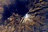
The volcano's crater at the top is oval-shaped. It measures 478 m (1,568 ft) (1,568 feet) across one way and 410 m (1,350 ft) (1,345 feet) across the other. The crater covers about 154,830 m2 (1,666,600 sq ft) (1.6 million square feet) and is up to 300 m (980 ft) (984 feet) deep. Pico de Orizaba is always covered by an ice cap made of several glaciers. The Jamapa Glacier, on the northeast side, has played a big role in shaping the volcano's landscape.
Where is Pico de Orizaba?
Pico de Orizaba is located at 19°1′48″N 97°16′12″W. It's about 110 kilometres (68 mi) (68 miles) west of the Gulf of Mexico. It's also about 200 kilometres (120 mi) (124 miles) east of Mexico City. The volcano sits on the border between the states of Veracruz and Puebla.
Orizaba marks the southeastern end of the Trans-Mexican Volcanic Belt. This is a chain of volcanoes that stretches from west to east across Central Mexico. About six kilometers (3.7 miles) southwest of Pico de Orizaba is a smaller peak called Sierra Negra. Sierra Negra is much lower than its giant neighbor. However, the road to the observatory on its summit is the highest road in North America!
Pico de Orizaba is part of the Sierra Madre Oriental mountain range. It acts like a wall between the coastal plains of the Gulf of Mexico and the Mexican Plateau. The volcano stops moisture from the Gulf of Mexico from reaching central Mexico. This affects the climate in both areas. Both Veracruz and Puebla states rely on Pico de Orizaba for fresh water. The largest river that starts on the volcano is the Jamapa River.
A Look Back in Time
Pico de Orizaba was very important to ancient cultures. These included the Nahuatl-speaking Aztecs and the Totonacs. The volcano is part of many old stories and beliefs of these native peoples.
During the Spanish Conquest of Mexico, Hernán Cortés traveled near the base of Pico de Orizaba. The volcano and nearby mountains made his journey to Tenochtitlan very hard and slow. In the 1600s, the Spanish government paid for roads to be built around Citlaltépetl. One road went south of the volcano, through Orizaba and Fortín de las Flores. This became the main trade route between Mexico City and the Gulf Coast. Later, Jesuits built a short road to set up communities at the base of the volcano. The Spanish used the volcano as a landmark to find their way to the port of Veracruz. Many battles were fought near this volcano during Mexico's fight for independence.
In 1839, Henri Guillaume Galeotti was the first European to explore the volcano. However, he did not reach the top. In 1848, during the American occupation of Mexico, two American soldiers, F. Maynard and William F. Raynolds, were the first known climbers to reach the summit of Pico de Orizaba. In 1851, a French explorer named Alejandro Doignon also reached the top. He found the flagpole that the Americans had left behind. In the mid-1800s, many scientists studied Citlaltépetl. This included the German botanist Hugo Fink, who was the first to write down the many types of plants found on the volcano. In 1873, Martin Tritschler raised the Mexican flag at the summit.
Pico de Orizaba National Park
To protect the natural beauty of Pico de Orizaba, President Lázaro Cárdenas created a national park on December 16, 1936. This park covers an area of 19,750 hectares (48,800 acres) (about 48,800 acres). It includes the volcano itself and the areas around it. The park also covers parts of the towns of Tlachichuca, Ciudad Serdán, La Perla, Mariano Escobedo, and Calcahualco. This protection became a federal law on January 4, 1937.
Climbing and Fun on the Mountain
Pico de Orizaba attracts many climbers from all over the world each year. There are different ways to approach and climb the volcano, and many people try to reach the top. Most climbers visit between October and March when the weather is best. Temperatures don't change much month to month because it's in the tropics. April through September are the rainy months.
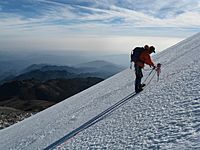
The most popular climbing route starts from a base camp called Piedra Grande Hut. This hut is located at an elevation of 4,270 m (14,010 ft) (14,009 feet) above sea level. From there, climbers usually go up the Jamapa Glacier.
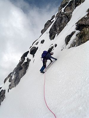
Another starting point is a high camp at the base of the glacier, around 4,900 m (16,100 ft) (16,076 feet). For experienced climbers looking for a bigger challenge, there's a technical ice climb called the Serpents Head. This climb involves ten sections of difficult ice. The southern side of the mountain also offers a tough climb. It's shorter but much steeper and harder. There are no glaciers on the southern side.
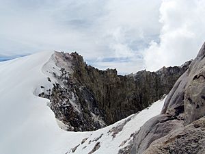
The final climb to the summit usually involves a straightforward glacier route without many deep cracks. It's also possible to walk around the edge of the volcano's crater. However, one part requires a short, tricky walk over steep rock and ice above the Glacier Este.
See also
 In Spanish: Citlaltépetl para niños
- List of mountain peaks of North America
- List of mountain peaks of Mexico
- List of volcanoes in Mexico
- List of Ultras of Mexico
- List of mountain peaks of Mexico
- List of elevation extremes by country
- Orizaba
- Volcanic Seven Summits
 | James Van Der Zee |
 | Alma Thomas |
 | Ellis Wilson |
 | Margaret Taylor-Burroughs |


