
Dulce River (Guatemala) facts for kids
Quick facts for kids Río Dulce |
|
|---|---|

Wildlife of Rio Dulce in Guatemala
|
|
| Lua error in Module:Location_map at line 420: attempt to index field 'wikibase' (a nil value).
Location of mouth
|
|
| Country | Guatemala |
| Department | Izabal |
| Physical characteristics | |
| Main source | Lake Izabal 88 m (289 ft) |
| River mouth | Livingston 0 m (Caribbean Sea) |
| Length | 43 km (27 mi) |
The Dulce River (which means "Sweet River" in Spanish, Spanish: Río Dulce) is a beautiful river in Guatemala. It is found entirely within the Izabal area. This river is part of a larger system of lakes and rivers. It has become a very popular spot for people who love to sail.
The river starts where water flows out of Lake Izabal. Right at the beginning of the river, there is an old Spanish fort. This fort is called the Castillo de San Felipe de Lara. It was built a long time ago to stop pirates. These pirates used to try to enter the lake from the Caribbean Sea.
Just after leaving Lake Izabal, the river goes under a very big bridge. This bridge is one of the largest in Central America. On one side of the bridge is a town called Fronteras. People often call this town Río Dulce. It is the main place for shopping and business in the area. Fronteras has a lively market where people sell vegetables. Many locals arrive at the market in special boats called cayucos. Some of these boats have small motors, but many people still paddle them by hand.
On the other side of the bridge is a town called El Relleno. Close by, you can find Casa Guatemala. This is a special village for children. It is an orphanage that cares for about 250 children. It also provides them with education and food.

From Fronteras, the river flows east for a few kilometers. Along this part of the river, you will see several marinas and resorts. The river then opens up into a long, narrow lake. This lake is called El Golfete. It has an island and a large, safe place for boats to anchor. A few homes and small shops are located along its shores. El Golfete is about 16 kilometres (10 mi) long.
After El Golfete, the river twists and turns for about 10 kilometres (6 mi). This part of the river is a spectacular gorge. The sides of the gorge rise very high, up to 91 metres (300 ft) on both sides. These steep walls are covered with many trees. You can see teak, mahogany, and palm trees. Bright wild flowers bloom everywhere. If you are lucky, you might spot howler monkeys and colorful toucans. After it rains, waterfalls can be seen flowing down the sides of the gorge.
Finally, the river reaches the Caribbean Sea. It flows into the sea near the town of Livingston. This town is home to the Garifuna people.
Contents
Exploring the Río Dulce National Park
| Río Dulce National Park | |
|---|---|
| Location | Izabal, Guatemala |
| Area | 130 km2 (50 sq mi) |
| Elevation | 90 m (300 ft) |
| Established | Acuerdo Gubernativo 28-05-55, 23-08-88,182-93 |
| Operator | CONAP |
The Río Dulce National Park is a protected area in the Izabal region of Guatemala. This park was created to protect the beautiful nature around the Dulce River. It covers an area of 130 square kilometres (50 sq mi). This includes the land along the river banks and the waters of El Golfete. The park helps keep the plants and animals in this special place safe. It was officially established in 1955.
Río Dulce in Movies: Tarzan's Adventures
The movie The New Adventures of Tarzan was filmed in Guatemala in 1935. Some scenes were shot right here in the Río Dulce area. Back then, it was possible to take special tours to see the banana farms and ancient Maya cities. These tours also offered boat trips along the Río Dulce and Lake Izabal. This allowed visitors to experience the amazing scenery, just like in the movie.
Images for kids
-
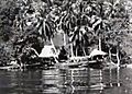
Homes by Río Dulce, seen from a steamboat.
-
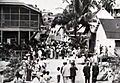
A tourist in Livingston, after sailing Río Dulce.
-

At the train station in Izabal.


See also
 In Spanish: Río Dulce (Guatemala) para niños
