List of rivers of Guatemala facts for kids
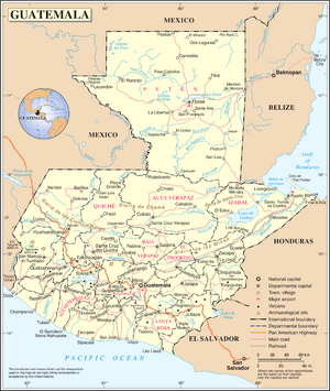
Guatemala is a country in Central America with many important rivers. These rivers flow across the land and eventually empty into larger bodies of water. A drainage basin is like a giant bowl or area of land where all the rain and water from smaller streams flow into one main river. This main river then carries the water to a lake, a sea, or an ocean.
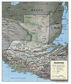
In Guatemala, rivers flow into three main drainage basins: the Gulf of Mexico, the Gulf of Honduras, and the Pacific Ocean. Each basin collects water from different parts of the country.
Contents
Rivers Flowing to the Gulf of Mexico
These rivers start in Guatemala and flow north. They join larger rivers in Mexico, like the Grijalva River, before reaching the Gulf of Mexico.
- Grijalva River (Mexico)
- Usumacinta River (Guatemala and Mexico)
- San Pedro River (Guatemala and Mexico)
- Lacantún River (Mexico)
- Xalbal River (Also called Xaclbal River)
- Ixcán River
- Pasión River (Río de la Pasión)
- San Juan River
- Usumacinta River (Guatemala and Mexico)
-
-
-
- Machaquila River
- Cancuén River
- Salinas River
- Chixoy River (Also known as Río Negro)
-
-
-
-
-
- San Román River
-
- Seleguá River (Guatemala and Mexico)
- Nentón River (Guatemala and Mexico)
- Cuilco River (Guatemala and Mexico)
- Cabajchum River
- Tzalá River
- Las Manzanas River
- Blanco River (San Marcos)
- Cabajchum River
-
Rivers Flowing to the Gulf of Honduras
These rivers flow east from Guatemala into the Gulf of Honduras. The Gulf of Honduras is part of the Caribbean Sea, which connects to the Gulf of Mexico.
- Hondo River (Also called Río Azul) (Belize and Mexico)
- Belize River (Belize)
- Mopan River (Guatemala and Belize)
- Moho River (Guatemala and Belize)
- Sarstoon River (Also called Sarstún River) (Guatemala and Belize)
- Gracias a Dios River
- Chiyu River
- Chahal River
- Franco River
- Chocón River
- Gracias a Dios River
- Dulce River
- Chocón Machacas River
- Lake Izabal
- Polochic River
- Matanzas River
- Cahabón River
- Polochic River
*Lanquin River
- Motagua River (Guatemala and Honduras)
- Las Animas River
- Bobos River
- Pasabien River
- Río Grande de Zacapa
- Jupilingo River
- Las Vacas River
- Jalapa River
Rivers Flowing to the Pacific Ocean
These rivers flow west from Guatemala directly into the Pacific Ocean.
- Suchiate River (Guatemala and Mexico)
- Cabúz River
- Cutzulchimá River
- Ixben River
- Nica River
- Petacalapa River
- Sibinal River
- Cabúz River
- Naranjo River
- Chisna River
- Mujulia River
- Chisna River
- Ocosito River
- Nil River
- Nima River
- Nil River
- Samalá River
- El Tambor River
- Nima I River
- Nima II River
- Oc River
- El Tambor River
- Icán River
- Sís River
- Nahualate River
- Ixtacapa River
- Siguacán River
- Madre Vieja River
- Coyolate River
- Xaya River
- San Cristobal River
- Pantaleón River
- Acomé River
- Achiguate River
- María Linda River
- Aguacapa River
- Michatoya River
- Paso Hondo River
- Los Esclavos River
- Paz River (Guatemala, El Salvador)
- Lempa River (Guatemala, El Salvador, Honduras)
See also
 In Spanish: Anexo:Ríos de Guatemala para niños
- List of rivers of the Americas by coastline
 | Bessie Coleman |
 | Spann Watson |
 | Jill E. Brown |
 | Sherman W. White |


