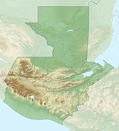
Achiguate River facts for kids
Quick facts for kids Achiguate River |
|
|---|---|
|
Location of mouth
|
|
| Country | Guatemala |
| Physical characteristics | |
| Main source | Guatemala (Sacatepéquez, Escuintla) 1,710 m (5,610 ft) 14°26′57″N 90°51′05″W / 14.449060°N 90.851355°W |
| River mouth | Pacific Ocean 0 m (0 ft) 13°54′55″N 90°54′29″W / 13.915364°N 90.908003°W |
The Río Achiguate is a river located in the southern part of Guatemala. It starts high up in the mountains and flows all the way to the Pacific Ocean. This river is an important natural feature in the region.
About the Achiguate River
The Achiguate River gets its water from the Sierra Madre mountain range. This area is known for its beautiful, tall mountains. The river begins on the southern side of the Volcán de Fuego. This is an active volcano.
Where Does It Flow?
The river's journey starts in two areas: Sacatepéquez and Escuintla. These are departments, like states or provinces, in Guatemala. From the mountains, the river flows south. It passes through the flat coastal lands of Escuintla. Finally, it reaches the Pacific Ocean.
Volcanoes and the River
The Achiguate River flows very close to the active Fuego volcano. Because of this closeness, there are some natural risks. When the volcano erupts, it can cause heavy ashfall and rain. This can lead to floods and mudslides in the river area. Local communities need to be prepared for these events.
See also
 In Spanish: Río Achiguate para niños
 | Madam C. J. Walker |
 | Janet Emerson Bashen |
 | Annie Turnbo Malone |
 | Maggie L. Walker |


