Aguacapa River facts for kids
Quick facts for kids Aguacapa River |
|
|---|---|

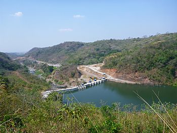
El Cóbano Hydroelectric Dam
|
|
| Country | Guatemala |
| Physical characteristics | |
| Main source | 1,850 m (6,070 ft) 14°30′31″N 90°28′10″W / 14.5086°N 90.4695°W |
| River mouth | Tributary of the María Linda River 580 m (1,900 ft) 14°16′47″N 90°31′36″W / 14.2797°N 90.5266°W |
The Aguacapa River (pronounced ah-gwah-KAH-pah) is an important river in Guatemala. It begins high up in the hills south-east of Guatemala City. The river starts at an altitude of about 1,850 meters (6,070 feet).
From its source, the Aguacapa River flows south. It passes through two different areas, called departments. These are the Guatemala Department and the Santa Rosa Department. Finally, the Aguacapa River joins another river, the Maria Linda River. The Maria Linda River then flows into the Pacific Ocean.
| Top - 0-9 A B C D E F G H I J K L M N O P Q R S T U V W X Y Z |
How the Aguacapa River Helps Guatemala
The Aguacapa River is very useful for generating electricity. This is done using special power plants called hydroelectric dams.
Generating Power with Dams
A hydroelectric dam uses the power of flowing water to create electricity. The water turns large machines called turbines. These turbines then make electricity.
- In 1981, the river was dammed to power the Aguacapa Hydroelectric Power Plant. This plant helps provide electricity to homes and businesses.
- Later, in 2015, a second dam was built. This new dam helps power the El Cóbano Hydroelectric Power Plant.
These dams are important for Guatemala. They provide clean energy from the river's natural flow.
See also
 In Spanish: Río Aguacapa para niños

