Cahabón River facts for kids
Quick facts for kids Cahabón River |
|
|---|---|

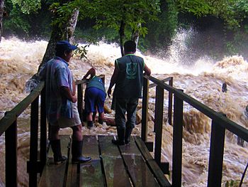
The Cahabòn in flood at Semuc Champey
|
|
| Native name | Río Cahabón (Spanish) |
| Country | Guatemala |
| Physical characteristics | |
| Main source | Tactic, Guatemala 1,600 m (5,200 ft) 15°19′18″N 90°20′17″W / 15.321549°N 90.338169°W |
| River mouth | Polochic River 90 m (300 ft) 15°25′21″N 89°00′00″W / 15.422463°N 89°W |
| Length | 195.95 km (121.76 mi) |
| Basin features | |
| Basin size | 2,459 km2 (949 sq mi) |
The Cahabón River (or Río Cahabón in Spanish) is a long river in eastern Guatemala. It stretches for about 196 kilometers (122 miles). This river is an important part of the natural landscape in the region.
Where the River Flows
The Cahabón River starts high up in the Sierra de las Minas mountains. These mountains are located in an area called Baja Verapaz. From there, the river first flows north. Then, it turns and heads east.
As it travels, the river enters another region called Alta Verapaz. It passes through several towns and places. These include Santa Cruz Verapaz, Tactic, Cobán, San Pedro Carchá, and Santa María Cahabón.
One famous spot the river flows through is Semuc Champey. This is a beautiful natural monument. Finally, the Cahabón River joins a smaller river called the Polochic River.
Fun on the River: Rafting
The Cahabón River is known for its exciting sections of whitewater. This happens when the river flows fast over rocks. It creates foamy, bubbly water. These parts of the river have what are called rapids.
Rapids are like natural roller coasters on the water. The Cahabón River has Class III and Class IV rapids. This means they are from intermediate to challenging levels. Because of these fun rapids, the river is a popular place for river rafting. People come from all over to enjoy this adventurous water sport.
See also
- Lake Chichoj
 In Spanish: Río Cahabón para niños
 | William M. Jackson |
 | Juan E. Gilbert |
 | Neil deGrasse Tyson |

