
San Pedro Carchá facts for kids
Quick facts for kids
San Pedro Carchá
|
|||
|---|---|---|---|
|
Municipality
|
|||

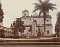
Municipal palace, San Pedro Carchá, 1980
|
|||
|
|||
| Nickname(s):
Carchá
|
|||

San Pedro Carchá
Location in Guatemala
|
|||
| Country | |||
| Department | |||
| Municipality | San Pedro Carchá | ||
| Government | |||
| • Type | Municipal | ||
| Area | |||
| • Municipality | 1,310 km2 (510 sq mi) | ||
| Elevation | 1,282 m (4,206 ft) | ||
| Highest elevation | 2,100 m (6,900 ft) | ||
| Lowest elevation | 600 m (2,000 ft) | ||
| Population
(Census 2018)
|
|||
| • Municipality | 235,275 | ||
| • Density | 179.6/km2 (465.2/sq mi) | ||
| • Urban | 16,353 | ||
| • Ethnicities | Q'eqchi' Poqomchi' Ladino | ||
| • Religions | Roman Catholicism Evangelicalism Maya | ||
| Climate | Cfb | ||
| Website | municipal site | ||


San Pedro Carchá, often called Carchá, is a town and a special area (called a municipality) in the Alta Verapaz region of Guatemala. It's quite high up, about 1,282 meters (or 4,206 feet) above the sea level. The whole municipality covers a large area of 1,310 square kilometers.
In 2018, about 235,275 people lived in the municipality. Out of these, 16,353 people lived right in the town of Carchá itself.
Contents
Sports in Carchá
The local football club is called Deportivo Carchá. They play their home games at the Estadio Juan Ramon Ponce Guay stadium. This team even played in Guatemala's top football league from 1998 to 2001.
Northern Transversal Strip
Lua error in Module:Location_map at line 420: attempt to index field 'wikibase' (a nil value). The Northern Transversal Strip is a special area in Guatemala. It was officially created in 1970 by the government of General Carlos Arana Osorio. This area was set aside to help with farming and agricultural growth.
The law that created it, Legislative Decree 60–70, said it was important for the country to develop farms in this region. San Pedro Carchá is one of the municipalities included in this important strip.
Climate and Weather
San Pedro Carchá has a warm and mild climate. This type of weather is known as Cfb in the Köppen climate classification system. This means it has warm summers and cool, but not cold, winters.
| Climate data for San Pedro Carchá | |||||||||||||
|---|---|---|---|---|---|---|---|---|---|---|---|---|---|
| Month | Jan | Feb | Mar | Apr | May | Jun | Jul | Aug | Sep | Oct | Nov | Dec | Year |
| Daily mean °C (°F) | 16.5 (61.7) |
17.4 (63.3) |
18.7 (65.7) |
19.7 (67.5) |
20.4 (68.7) |
20.4 (68.7) |
20.0 (68.0) |
20.0 (68.0) |
20.0 (68.0) |
19.0 (66.2) |
18.0 (64.4) |
16.9 (62.4) |
18.9 (66.1) |
| Average precipitation mm (inches) | 128 (5.0) |
99 (3.9) |
111 (4.4) |
105 (4.1) |
183 (7.2) |
309 (12.2) |
266 (10.5) |
238 (9.4) |
306 (12.0) |
318 (12.5) |
235 (9.3) |
146 (5.7) |
2,444 (96.2) |
| Source: Climate-Data.org | |||||||||||||
Where is San Pedro Carchá?
San Pedro Carchá is surrounded by other municipalities in the Alta Verapaz department. Here's a look at its neighbors:
 |
Chisec | Fray Bartolomé de las Casas | |
|
| Cobán | Cahabón, Lanquín and Senahú | |||
| San Juan Chamelco |
Images for kids
-
San Pedro Carcha Church

See also
 In Spanish: San Pedro Carchá para niños
