Isla de Aves facts for kids

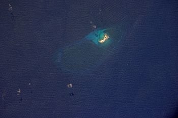
Isla de Aves from space, 2001
|
|
| Geography | |
|---|---|
| Location | Caribbean Sea |
| Coordinates | 15°40′18″N 63°36′59″W / 15.67167°N 63.61639°W |
| Length | 376 m (1,234 ft) |
| Width | 50 m (160 ft) |
| Highest elevation | 4 m (13 ft) |
| Administration | |
Isla de Aves (which means "Island of Birds" in Spanish) is a small piece of land that belongs to Venezuela. It's also called Aves Island. This tiny island has been the subject of many arguments between countries in the past. These arguments were about who owned the island. Countries like the United States, Dominica, the Netherlands, and the United Kingdom were involved. Luckily, these arguments are now settled.
Isla de Aves is located in the Caribbean Sea, west of the Windward Islands. It's very small, about 375 meters (1,230 feet) long and 50 meters (164 feet) wide. On a calm day, it rises only 4 meters (13 feet) above the sea. The island is mostly sand, with a few small plants. Sometimes, during big storms like hurricanes, the island can even be completely covered by water! It's quite far from other land, about 185 kilometers (115 miles) southwest of Montserrat and 547 kilometers (340 miles) north of mainland Venezuela.
Contents
How Hurricanes Affect the Island
Isla de Aves is always at risk of being washed away by the ocean. The Venezuelan government is looking for ways to protect it. This is important because the island helps Venezuela claim a larger area of the Caribbean Sea.
In 1980, a strong storm called Hurricane Allen actually split the island into two parts. But over time, new coral grew and joined the parts back together. Later, in 2007, Hurricane Dean caused a lot of erosion, meaning it wore away a lot of the island's sand and land.
Wildlife and Nature
Isla de Aves is a very important spot for animals. It's a resting and breeding place for many kinds of seabirds. It's also a crucial nesting site for the green sea turtle (Chelonia mydas). These turtles travel long distances to lay their eggs on the island's sandy shores.
Because the island is so low and flat, it's hard for ships to see. This has caused many ships to crash there over the years.
Amateur Radio and Expeditions
Isla de Aves is a special place for amateur radio enthusiasts, also known as "ham" radio operators. It's considered a very rare location to contact. In 2006, a group of ham radio operators planned for 14 years to visit the island. During their week-long stay, they made over 42,000 radio contacts with people all over the world!
Island History
Isla de Aves was probably found by Avaro Sanzze in 1584, but no one lived there permanently. Over the centuries, several countries tried to claim it, including Great Britain, Spain, Portugal, and the Netherlands. People from the nearby Dutch islands of Saint Eustatius and Saba often visited Aves to collect turtle and bird eggs.
Guano Mining and Disputes
In 1854, an American ship captain found a lot of guano (bird droppings used as fertilizer) on the island. Soon, people started collecting it. Both the Dutch and Venezuelan governments protested this. The United States even passed a law called the Guano Islands Act in 1856, which allowed Americans to claim islands with guano if they were "abandoned." This led to more arguments over who owned Isla de Aves.
In 1865, Isabella II, the Queen of Spain, was asked to decide who owned the island. She ruled that Isla de Aves belonged to Venezuela. However, her decision also said that people from the Dutch islands of St. Eustatius, Saba, and St. Maarten had the right to fish in the waters around Aves. The Dutch accepted this ruling.
From 1878 to 1912, American miners returned to the island to collect guano until it ran out.
Venezuelan Control
Isla de Aves became an official part of Venezuela in 1895, during the time of President Joaquín Crespo. By 1905, it was even a small local area called "Municipio Oriental."
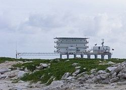
In 1950, the Venezuelan Navy sent soldiers to take full control of the island. Later, in 1978, they built a scientific naval base called Simón Bolívar on the island. This base was built on stilts over the water and was home to scientists and military personnel.

Agreements with Other Countries
Venezuela has made agreements with other countries about the sea borders around Isla de Aves.
- In 1978, Venezuela and the United States agreed on their sea border between Isla de Aves and Puerto Rico. This agreement became official in 1980. Isla de Aves is the closest Venezuelan land to the U.S., about 163 miles (262 km) from St. Croix.
- In 1980, Venezuela also agreed with France on the sea border between Isla de Aves and the French islands of Guadeloupe and Martinique.
- In 2006, the Prime Minister of Dominica, Roosevelt Skerrit, visited Venezuela and said that Aves Island belongs to Venezuela. This unofficially ended Dominica's claim to the island.
Historical Maps
-
Before Hurricane Allen (1980)
-
After Hurricane Allen (1980)
See also
 In Spanish: Isla de Aves para niños
- Ankoko Island (another disputed territory involving Venezuela)
- Exclusive economic zone
- Federal Dependencies of Venezuela
- List of territorial disputes
 | Laphonza Butler |
 | Daisy Bates |
 | Elizabeth Piper Ensley |


