
Kingston, Jamaica facts for kids
Quick facts for kids
Kingston
|
|
|---|---|

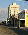
The port of Kingston in 2004
|
|
| Motto(s):
A city which hath foundations
|
|

Kingston
Location in Jamaica

Kingston
Location in North America
|
|
| Country | Jamaica |
| County | Surrey |
| Parish | Kingston St. Andrew |
| Established | 22 July 1692 |
| Area | |
| • Parish | 480 km2 (190 sq mi) |
| Elevation | 9 m (30 ft) |
| Population
(2011)
|
|
| • Parish | 662,435 |
| • Rank | 65th in North America 1st in Jamaica |
| • Density | 1,380/km2 (3,570/sq mi) |
| • Metro | 1,190,000 |
| Time zone | UTC−05:00 (Eastern Time Zone) |
| • Summer (DST) | (Not Observed) |
Kingston is the capital city and the largest city in Jamaica. It is located on the southeastern coast of the island. Kingston has a natural harbour that is protected by a long sand spit called the Palisadoes. This sand spit connects the town of Port Royal and the Norman Manley International Airport to the rest of the island. Kingston is the largest English-speaking city in the Western Hemisphere south of the United States.
The local governments of the parishes of Kingston and Saint Andrew joined together in 1923. They formed the Kingston and St. Andrew Corporation (KSAC). The area under the KSAC is often called "Greater Kingston" or the "Corporate Area." This area includes more than just Kingston Parish. In 2011, Kingston Parish had about 89,000 people, and St. Andrew Parish had about 573,000 people.
Kingston city is surrounded by communities like Six Miles to the west and Stony Hill to the north. Papine is to the northeast, and Harbour View is to the east. These are all part of urban and suburban Saint Andrew.
Kingston has two main central areas: the historic Downtown and New Kingston. Both areas are served by Norman Manley International Airport. There is also a smaller airport, Tinson Pen Aerodrome, mainly for flights within Jamaica.
Contents
- History of Kingston
- People of Kingston (Demographics)
- Religions in Kingston
- Kingston's Economy
- Geography and Climate
- Housing in Kingston
- Parks and Green Spaces
- Transportation in Kingston
- Law Enforcement and Safety
- Media in Kingston
- Sports in Kingston
- Telecommunications
- Postal Service
- Important Institutions
- Sister Cities
- Images for kids
- See also
History of Kingston


Kingston was founded on July 22, 1692. This happened shortly after a big earthquake in 1692 that destroyed Port Royal. The first part of Kingston was built to house the people who survived that earthquake.
Before the earthquake, Kingston was mainly used for farming. After the earthquake, survivors set up a camp by the sea. Sadly, about two thousand people died from diseases carried by mosquitoes. The town started to grow more after Port Royal was destroyed again by fire in 1703.
A surveyor named John Goffe designed the new town with a grid pattern. This grid system made it easier for trade and transportation. By 1716, Kingston had become the largest town and the main trading center for Jamaica. Wealthy merchants began moving their homes to the farmlands north of the city.
The first free school, Wolmers's, opened in 1729. There was also a theater, which moved to North Parade in 1774. Both are still around today. In 1755, the governor, Sir Charles Knowles, wanted to move the government offices from Spanish Town to Kingston. By 1780, Kingston had a population of 11,000 people. Merchants pushed for the capital to be moved from Spanish Town, which was becoming less important than Kingston.
The Church of St. Thomas on King Street was first built before 1699. It was rebuilt after the 1907 earthquake. By the late 1700s, Kingston had over 3,000 brick buildings. The harbor helped with trade, and the city was involved in several naval wars. Kingston took over many important roles from Spanish Town. These included farming, trade, processing goods, and being a main transport hub.
In 1788, Kingston had a population of 25,000. This was about one-tenth of the island's total population. About one in four people in Kingston were white. There was also a large number of free people of color. Three-fifths of Kingston's population were enslaved black people.
The government officially moved its offices from Spanish Town to Kingston in 1872. In 1882, a large fire happened in Kingston. In 1892, electricity first came to Jamaica, starting in Kingston.
.jpg)

In 1907, another earthquake, known as the 1907 Kingston earthquake, killed 800 people. It destroyed almost all the old buildings south of Parade. After this, a rule was made that buildings in the city center could not be taller than 60 feet (about 18 meters). New buildings were made with strong reinforced concrete.

In the 1930s, riots across the island led to the creation of trade unions and political parties. These groups aimed to represent workers' rights.
The city became home to the Mona campus of the University of the West Indies. It was founded in 1948 with 24 medical students.
In the 1960s, reggae music became popular worldwide. At the same time, Kingston's city center waterfront area was greatly expanded. By the 1980s, many old buildings were torn down. The entire waterfront was rebuilt with hotels, shops, offices, cultural centers, and facilities for cruise and cargo ships.
In 1966, Kingston hosted the Commonwealth Games.

People of Kingston (Demographics)
Most people in Kingston are of African descent. There are also large groups of East Indians and Chinese people. They came to Jamaica in the late 1800s as indentured servants (people who agreed to work for a period of time in exchange for passage to the country). Chinese people play important roles in Jamaica's economy, especially in retail markets.
There are also smaller groups of Europeans, mostly from Germany and Great Britain. Syrians and Lebanese people are a small but very influential group in Kingston and across the island. Even though they are a minority, a Lebanese person, Edward Philip George Seaga, became one of Jamaica's prime ministers. Many Jamaicans are of mixed race, forming the second largest group. There is also a small Jewish population in the city.
Who Lives in Kingston?
Religions in Kingston
Kingston has many different Christian churches. Most of them are Protestant. The main Christian groups include the Church of God, Baptist, Anglican, Methodist, Roman Catholic, Seventh-day Adventist, and Pentecostal.
There is a strong Roman Catholic community in Kingston. The Holy Trinity Cathedral is the main Catholic church and was opened in 1911. There are also several Catholic schools, like Immaculate Conception High School and St. Francis Primary and Infant School. Holy Childhood High School was started by the Franciscan Missionary Sisters.
Afro-Christian religions like the Rastafari movement also have many followers.
The Shaare Shalom Synagogue serves Kingston's Jewish community. The city also has communities of Hindus, Buddhists, and Muslims. The Islamic Council of Jamaica and the Islamic Education and Dawah Centre are both in Kingston. There are also three groups of the Church of Jesus Christ of Latter-day Saints in the city.
Kingston's Economy

Kingston is very important to Jamaica's economy. Most of the country's economic activity happens in Kingston. Since most government offices are in the city, Kingston plays a key role in making laws about Jamaica's money. Because many people live in the capital, most money transactions happen here, which helps Jamaica's local economy.
Kingston also has the most schools, hospitals, and universities in Jamaica. It is the island's main transportation center and its largest seaport.
Many large international companies and financial groups have their main offices in and around Kingston. Air Jamaica used to have its headquarters here. There have been ideas to make Jamaica an International Financial Centre. This would help Kingston's financial sector and create more jobs for professionals like accountants and lawyers.
The city's main industries include tourism, making clothes, and shipping. Many international goods are traded through Kingston's seaport. Major exports include bauxite (a type of ore), sugar, and coffee. Kingston is also a popular place for tourists, and tourism is a big part of its economy.
Recently, the city has faced economic challenges, like the rest of Jamaica. Plans to help the city's economy include many projects to rebuild downtown Kingston. There have also been efforts to grow the manufacturing industry and attract call centers to the city.
Geography and Climate

Kingston is surrounded by the Blue Mountains, Red Hills, Long Mountain, and the Kingston Harbour. The harbor is the seventh largest natural harbor in the world. The city is on the Liguanea plain, which is a flat area next to the Hope River. Kingston often experiences earthquakes, like the one in 1907.
Kingston has a tropical climate, which means it's usually warm. It has a wet season from May to November, which is also hurricane season. The dry season is from December to April. During the dry season, there isn't much rain. However, cold fronts can bring heavy showers, especially in March.
Kingston is in the rain shadow of the Blue Mountains. This means that most of the moisture carried by the Northeast Trade Winds falls on the other side of the mountains. Because of this, Kingston is very dry compared to places like Portland and Saint Mary. Since Kingston is on the coast, the sea influences its weather. In recent times, temperatures in Kingston have been as high as 38.8°C (101.8°F) and as low as 13.4°C (56.1°F).
| Climate data for Kingston (St. George's College, Jamaica) | |||||||||||||
|---|---|---|---|---|---|---|---|---|---|---|---|---|---|
| Month | Jan | Feb | Mar | Apr | May | Jun | Jul | Aug | Sep | Oct | Nov | Dec | Year |
| Mean daily maximum °C (°F) | 30.3 (86.5) |
30.2 (86.4) |
30.7 (87.3) |
31.1 (88.0) |
31.6 (88.9) |
32.1 (89.8) |
32.8 (91.0) |
32.7 (90.9) |
32.1 (89.8) |
31.7 (89.1) |
31.2 (88.2) |
30.6 (87.1) |
31.4 (88.5) |
| Daily mean °C (°F) | 25.7 (78.3) |
25.6 (78.1) |
26.2 (79.2) |
26.9 (80.4) |
27.6 (81.7) |
28.2 (82.8) |
28.6 (83.5) |
28.5 (83.3) |
28.1 (82.6) |
27.6 (81.7) |
27.0 (80.6) |
26.2 (79.2) |
27.2 (81.0) |
| Mean daily minimum °C (°F) | 21.1 (70.0) |
21.0 (69.8) |
21.6 (70.9) |
22.6 (72.7) |
23.6 (74.5) |
24.2 (75.6) |
24.3 (75.7) |
24.2 (75.6) |
24.0 (75.2) |
23.4 (74.1) |
22.8 (73.0) |
21.8 (71.2) |
22.9 (73.2) |
| Average precipitation mm (inches) | 18 (0.7) |
19 (0.7) |
20 (0.8) |
39 (1.5) |
100 (3.9) |
74 (2.9) |
42 (1.7) |
98 (3.9) |
114 (4.5) |
177 (7.0) |
65 (2.6) |
47 (1.9) |
813 (32.0) |
| Average precipitation days | 5 | 5 | 5 | 7 | 8 | 7 | 6 | 9 | 11 | 14 | 10 | 6 | 93 |
| Average relative humidity (%) (at 13:00) | 64 | 64 | 64 | 66 | 68 | 67 | 64 | 66 | 71 | 73 | 69 | 65 | 67 |
| Mean monthly sunshine hours | 257.3 | 240.1 | 260.4 | 258.0 | 254.2 | 237.0 | 260.4 | 257.3 | 213.0 | 223.2 | 222.0 | 235.6 | 2,918.5 |
| Mean daily sunshine hours | 8.3 | 8.5 | 8.4 | 8.6 | 8.2 | 7.9 | 8.4 | 8.3 | 7.1 | 7.2 | 7.4 | 7.6 | 8.0 |
| Source: Meteorological Service (Jamaica) | |||||||||||||
| Climate data for Kingston, Jamaica (Norman Manley International Airport) extremes 1852–present | |||||||||||||
|---|---|---|---|---|---|---|---|---|---|---|---|---|---|
| Month | Jan | Feb | Mar | Apr | May | Jun | Jul | Aug | Sep | Oct | Nov | Dec | Year |
| Record high °C (°F) | 35.1 (95.2) |
34.8 (94.6) |
35.1 (95.2) |
35.7 (96.3) |
35.0 (95.0) |
36.9 (98.4) |
37.1 (98.8) |
36.1 (97.0) |
35.8 (96.4) |
35.4 (95.7) |
37.1 (98.8) |
35.0 (95.0) |
37.1 (98.8) |
| Mean daily maximum °C (°F) | 29.8 (85.6) |
29.6 (85.3) |
29.8 (85.6) |
30.3 (86.5) |
30.8 (87.4) |
31.2 (88.2) |
31.7 (89.1) |
31.9 (89.4) |
31.7 (89.1) |
31.3 (88.3) |
31.1 (88.0) |
30.5 (86.9) |
30.8 (87.4) |
| Mean daily minimum °C (°F) | 22.3 (72.1) |
22.3 (72.1) |
22.9 (73.2) |
22.6 (72.7) |
24.7 (76.5) |
25.3 (77.5) |
25.6 (78.1) |
25.3 (77.5) |
25.3 (77.5) |
24.8 (76.6) |
24.1 (75.4) |
23.1 (73.6) |
24.0 (75.2) |
| Record low °C (°F) | 18.5 (65.3) |
18.0 (64.4) |
18.0 (64.4) |
19.2 (66.6) |
20.0 (68.0) |
21.0 (69.8) |
20.6 (69.1) |
19.9 (67.8) |
20.0 (68.0) |
19.0 (66.2) |
19.0 (66.2) |
18.0 (64.4) |
18.0 (64.4) |
| Average precipitation mm (inches) | 18 (0.7) |
16 (0.6) |
14 (0.6) |
27 (1.1) |
100 (3.9) |
83 (3.3) |
40 (1.6) |
81 (3.2) |
107 (4.2) |
167 (6.6) |
61 (2.4) |
31 (1.2) |
745 (29.3) |
| Average precipitation days | 10 | 8 | 7 | 9 | 11 | 7 | 6 | 6 | 9 | 12 | 11 | 9 | 105 |
| Average relative humidity (%) (at 13:00) | 81 | 77 | 76 | 78 | 78 | 75 | 75 | 76 | 78 | 78 | 80 | 81 | 78 |
| Mean monthly sunshine hours | 226.3 | 211.9 | 241.8 | 228.0 | 229.4 | 234.0 | 266.6 | 254.2 | 234.0 | 232.5 | 225.0 | 226.3 | 2,810 |
| Mean daily sunshine hours | 7.3 | 7.5 | 7.8 | 7.6 | 7.4 | 7.8 | 8.6 | 8.2 | 7.8 | 7.5 | 7.5 | 7.3 | 7.7 |
| Source 1: Meteorological Service (Jamaica) | |||||||||||||
| Source 2: Meteo Climat (record highs and lows) | |||||||||||||
Housing in Kingston
In 1848, the Jamaican government expanded Kingston by building new homes. These homes were in the west, north, and east of the city. By 1860, most wealthy white families lived on the edges of the city.
As Kingston's population grew, existing neighborhoods became very crowded. Marshes in the southwest were filled in to create space for new housing. By 1935, continued population growth and poverty led to the creation of slums in the east and west of the city. Later, the government tore down these areas. Residents were moved to Denham Town. This new development housed 3,000 people. However, more than one-sixth of the displaced residents became homeless. This meant overcrowding continued throughout the city. Crowded living conditions also led to public health problems.
People also started moving to the suburbs. By the 1960s, residential areas spread to the foothills of the Blue Mountains. Later, because of a lack of space, this area expanded to the east of the mountains.
Today, about 20% of Kingston's population lives in informal settlements. On the other hand, Kingston is also home to very expensive neighborhoods. These include Red Hills, Norbrook, Cherry Gardens, Stony Hill, and Jack's Hill.
Parks and Green Spaces
Kingston has several city parks. These parks are often used for different events and celebrations throughout the year. Some of the most popular parks are:
- Emancipation Park
- Hope Gardens
- Devon House
- National Heroes' Park
- St William Grant Park
- Mandela Park
Emancipation Park
The Liguanea Club, a social club for the upper class, owned over 35 acres of land. This included the area now known as Emancipation Park. The club gave seven acres of this land to the Jamaican Government as a gift.
Some government members thought the land should be used for businesses. Others wanted a large entertainment complex. However, neither idea had enough money. In 2002, the government approved transferring the land to the National Housing Trust. The condition was that a park had to be built and maintained there. The land was transferred for just one Jamaican dollar.
The park is famous for a large bronze sculpture by Jamaican artist Laura Facey. It is 11 feet (about 3 meters) high and is at the park's main entrance. The sculpture shows two black male and female statues looking up at the sky. This symbolizes their victory and rise from the terrible times of slavery. The statue was revealed in July 2003.
Hope Gardens
The Royal Botanical Gardens at Hope, often called Hope Gardens, is a national attraction. Hope Gardens is part of 2,000 acres of land. This makes it the largest botanical garden in the English-speaking Caribbean. The land is located at the foot of the Blue Mountains. It was originally owned by Major Richard Hope, which is where it got its name.
In 1880, the Government of Jamaica bought 200 acres of this land. It was first used to introduce new plants and test crops like pineapple, cocoa, coffee, and tobacco. The formal Botanical Gardens were created on about 60 acres of this land. Experts from the Kew Gardens in England helped with this.
In the 1950s, the Queen visited the island and was pleased with the gardens. She gave permission for them to be called the Royal Botanical Gardens, Hope. The Gardens have many unique species of plants, along with some trees found only in Jamaica. Over the years, hurricanes and other disasters have caused the loss of many species. However, there are still many important trees and popular spots to see in the Gardens.
At Hope Gardens, visitors can see other features. These include the Coconut Museum, the Sunken Gardens, the Orchid House, the Lily Pond, the Maze, and Palm Avenue.
Hope Gardens also has a zoo next to it, called Hope Gardens Zoo. Both the gardens and the zoo are being improved. This is part of a campaign called "Bring Back The Hope."
Transportation in Kingston
Roads
St William Grant Park (Parade) is in the center of downtown Kingston. It is the starting point for three of Jamaica's four main roads. These are the A1 (Kingston to Lucea), the A3 (Kingston to Saint Ann's Bay), and the A4 (Kingston to Annotto Bay). Kingston itself has a large network of main and smaller roads.
The city also has Highway 2000, Jamaica. This highway goes through Portmore, Ocho Rios, and Mandeville. A new part of Highway 2000, called "T3," recently opened. It has greatly reduced travel time between Kingston and Montego Bay from 4 hours to just 2.5 hours.
Buses
Kingston has a modern bus system, mini buses, and taxis. They operate throughout the city. Major bus hubs are at Parade, Cross Roads, and Half Way Tree.
In June 1898, the old mule car service was replaced. Electric trams, first run by the West India Electric Company, then by the Jamaica Public Service Company, took over. This change to electric trams was finished on March 31, 1899. The tram service continued but could not keep up with the growing city. It stopped running on August 7, 1948.
From 1948 to 1953, a company called Jamaica Utilities ran a motor bus service. The government ended their contract in 1953.
From 1953 to 1983, the Jamaica Omnibus Service ran the bus service. At its busiest, it had over 600 buses. It served an area from Spanish Town to Port Royal. The government took over the company in 1974 and closed it in 1983.
Today, the Jamaica Urban Transit Company (JUTC) provides bus services.
Railways
The Kingston railway station is no longer used. It served the main railway line from Kingston to Montego Bay. This line had branches to other towns.
The railway station opened in 1845. All passenger train services in Jamaica stopped suddenly in October 1992.
Airports
Kingston's international airport is Norman Manley International Airport. Other international airports in Jamaica are Sangster International Airport and Ian Fleming International Airport in St. Ann. Tinson Pen Aerodrome in Kingston provides flights within Jamaica.
Sea Ports
Historically, the Kingston waterfront was Jamaica's main port. It had many piers where cargo and passenger ships could dock. More recently, with the use of large shipping containers, the main port has moved to Newport West.
Law Enforcement and Safety
Jamaica's police force, the Jamaica Constabulary Force, has its main office on Old Hope Road near Liguanea. Smaller police stations are located across the city. The Supreme Court of Jamaica is also in Kingston. Other courts, like the Half-Way-Tree Resident Magistrate's Court, are also located here.
The Jamaica Defence Force (JDF), which is Jamaica's military, has its headquarters at Up Park Camp near New Kingston. The JDF also has a major naval base at Port Royal.
Fire Service
The Jamaica Fire Brigade, which is the national fire service, provides fire response in Kingston. They operate from several fire stations across the city:
- York Park (Headquarters)
- Half-Way-Tree
- Rollington Town
- Port Royal
- Norman Manley International Airport
- Stony Hill
- Trench Town
- Kingston Harbour (Fire Boat)
Media in Kingston
Three of Jamaica's large newspaper companies are based in Kingston: The Gleaner Company, the Jamaica Observer, and the Sunday Herald.
Several television and radio stations are also located in Kingston. These include Television Jamaica (TVJ), CVM TV, RJR 94 FM, TBC Radio 88.5 FM, Hitz 92 FM, FAME 95 FM, LOVE TV, ZIP 103, Kool 97 FM, and LOVE FM.
Sports in Kingston

Cricket, including international test matches, is played at Sabina Park.
Kingston is home to five association football (soccer) teams that play in Jamaica's National Premier League. These teams are:
- Arnett Gardens
- Boys' Town
- Harbour View
- Maverley Hughenden
- Waterhouse
Olympic Sprinter Shelly-Ann Fraser-Pryce was born and grew up in the Waterhouse area of Kingston.
Telecommunications
Phone and Internet Services
Fixed phone and internet services in Kingston are provided by FLOW and Digicel. FLOW uses a mix of fiber and cable networks. This provides TV, phone, and internet speeds up to 100 Mbit/s. Digicel uses a fiber-optic network, offering TV, phone, and internet speeds up to 200 Mbit/s. Digicel's fiber network can handle speeds up to 10 Gbit/s.
Mobile Phone and Internet Services
Mobile phone and internet services in Kingston are mainly provided by FLOW and Digicel. Both companies offer 2G, 3G, and 4G LTE services in and around the city.
FLOW offers 3G+ speeds up to 21 Mbit/s. They also offer faster 3G+ (DC-HSPA+) speeds up to 42 Mbit/s. FLOW also offers 4G LTE in Kingston, with theoretical speeds up to 150 Mbit/s.
Digicel also offers 3G+ speeds up to 21 Mbit/s and faster 3G+ (DC-HSPA+) speeds up to 42 Mbit/s. Digicel was the first to offer 4G LTE in Jamaica. Their network covers all of Kingston Parish and most populated areas, with speeds up to 75 Mbit/s.
Kingston is also home to Caricel, Jamaica's newest phone company. They first launched their 4G LTE network in the Kingston area.
Both FLOW and Digicel have their main Jamaican offices in Kingston.
Postal Service
Postal services in Kingston and across Jamaica are provided by the Postal Corporation of Jamaica. This is Jamaica's national post office. Services include sending mail within Jamaica and internationally, post office boxes, and package delivery.
Kingston is divided into several postal zones, which help organize mail delivery:
| Zone name | Area served |
|---|---|
| Kingston CSO | (Central Sorting Office) Downtown Kingston |
| Kingston 1 | Port Royal |
| Kingston 2 | Bournemouth Gardens (Windward Road) |
| Kingston 3 | Vineyard Town |
| Kingston 4 | Allman Town |
| Kingston 5 | Cross Roads |
| Kingston 6 | Liguanea, Papine. |
| Kingston 7 | Mona August Town |
| Kingston 8 | Constant Spring Norbrook |
| Kingston 9 | Stony Hill |
| Kingston 10 | Half-Way-Tree |
| Kingston 11 | Richmond Park (Hagley Park Rd) |
| Kingston 12 | Jones Town |
| Kingston 13 | Whitfield Town |
| Kingston 14 | Denham Town |
| Kingston 15 | Tivoli Gardens |
| Kingston 16 | Franklyn Town |
| Kingston 17 | Harbour View |
| Kingston 19 | Havendale |
| Kingston 20 | Western District (Duhaney Park) |
Important Institutions
As the capital, Kingston is Jamaica's main center for finance, culture, economy, and industry. Many financial institutions are based in Kingston. The city also has the most hospitals, schools, universities, and cultural attractions on the island.
Some famous Kingston landmarks include:
- The University of the West Indies
- The Jamaica Defence Force Museum
- The Bob Marley Museum
An agency of the United Nations, the International Seabed Authority, has its headquarters in Kingston.
Sister Cities
Kingston is "twinned" with several cities around the world. This means they have special friendly relationships and often share cultural programs. Kingston's sister cities include:
- Miami-Dade County, Florida, United States
- Kalamazoo, Michigan, United States
- Topeka, Kansas, United States
- Gibraltar (United Kingdom)
- Coventry, Warwickshire, England
- Guadalajara, Mexico
- Shenzhen, People's Republic of China
- Panevėžys, Lithuania
- Windhoek, Namibia
Images for kids
-
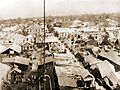
Bird's eye view of Kingston after the 1907 earthquake
-
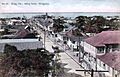
Kingston - King Street, looking south (1908)
-
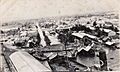
Kingston, Jamaica from the masthead of HMAS Melbourne - 1915
-
View of the central Kingston waterfront showing the Bank of Nova Scotia and the Bank of Jamaica
-
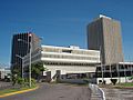
Former Air Jamaica headquarters
-
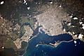
Photo of Kingston taken from the International Space Station
-
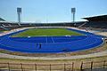
Independence Park National Stadium
See also
 In Spanish: Kingston para niños
