Arrondissement of Cayenne facts for kids
Quick facts for kids
Arrondissement of Cayenne
|
|
|---|---|

Cayenne in French Guiana
|
|
| Country | France |
| Region | French Guiana |
| Department | French Guiana |
| Communes | 14 |
| Prefecture | Cayenne |
| INSEE code | 9731 |
| Area | |
| • Total | 42,588.9 km2 (16,443.7 sq mi) |
| Population
(2014)
|
|
| • Total | 164,489 |
| • Density | 3.862250/km2 (10.00318/sq mi) |
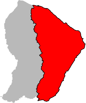
The arrondissement of Cayenne is like a special district in French Guiana. It's part of the French Guiana department, which is a region of France located in South America. The main city and capital of this district is Cayenne.
Contents
History of Cayenne's District
This district has an interesting past. When French Guiana became an overseas department of France in 1946, Cayenne was the only district of its kind there. This means it was the main administrative area for a long time.
Geography of the Cayenne Arrondissement
The Cayenne district is located in the eastern part of French Guiana. To the north, it touches the Atlantic Ocean. To the east and south, it shares borders with Brazil. On its western side, it is next to the Saint-Laurent-du-Maroni district.
This district is quite large. It covers an area of about 42,589 square kilometers (16,444 square miles). In 2014, around 164,489 people lived here.
What Makes Up the Cayenne District?
The Cayenne district is made up of 14 smaller areas called communes. Think of these as towns or local areas within the larger district. Each commune has its own local government and community.
Some of the biggest communes in the district include:
- Cayenne: This is the capital city and the largest commune.
- Matoury: A busy area near the capital.
- Kourou: Famous for its space center.
- Remire-Montjoly: A coastal town.
- Macouria: Another growing commune.
These communes work together to manage the district. They help with things like local services and community life.
Related pages
See also
 In Spanish: Distrito de Cayena para niños
 | Leon Lynch |
 | Milton P. Webster |
 | Ferdinand Smith |

