
Ucayali River facts for kids
Quick facts for kids Ucayali River |
|
|---|---|
_Rios_Tambo%2BUcayali.jpg)
Confluence of the Tambo (from bottom) and Urubamba Rivers (background right) forming the Ucayali River (background left)
|
|

Map of the Amazon Basin with the Ucayali River highlighted
|
|
| Country | Peru |
| Physical characteristics | |
| Main source | confluence of the Tambo and Urubamba Rivers Atalaya, Ucayali, Peru |
| River mouth | Amazon River confluence with Marañón River, Loreto, Peru |
| Length | 2,238 km (1,391 mi) 1,460 km (910 mi) |
| Discharge (location 2) |
|
| Basin features | |
| Basin size | 351,549 km2 (135,734 sq mi) |
| Tributaries | |
The Ucayali River is a very important river in Peru. It's considered the main starting point, or headstream, of the mighty Amazon River. The river begins about 110 km (68 mi) north of Lake Titicaca. It flows through the Arequipa region of Peru.
The Ucayali River officially becomes the Amazon River when it joins with the Marañón River near the city of Nauta. A big city called Pucallpa is also located right on the banks of the Ucayali.
Contents
What Makes the Ucayali River Special?
The Ucayali River, along with other rivers like the Apurímac River, the Ene River, and the Tambo River, is now seen as the main source of the Amazon River. This means that if you trace the Amazon River back to its furthest point, you would follow these rivers.
How Long is the Ucayali River System?
From the very beginning of the Apurímac River at Nevado Mismi all the way to where the Ucayali and Marañón Rivers meet, the total length is about 2,669.9 kilometres (1,659.0 mi). Here's how the lengths of the different parts add up:
- The Apurímac River is about 730.7 km (454.0 mi) long.
- The Ene River stretches for about 180.6 km (112.2 mi).
- The Tambo River is around 158.5 km (98.5 mi) long.
- The Ucayali River itself, from where it joins the Tambo River to its meeting point with the Marañón, is about 1,600.1 km (994.3 mi) long.
Exploring the Ucayali River
The Ucayali River has had many names over time, like San Miguel, Ucayare, Poro, Apu-Poro, Cocama, and Rio de Cuzco. People in Peru have sent many expeditions to explore this river.
Early Expeditions and Discoveries
One famous expedition in 1867 claimed to have gotten within 380 km (240 mi) of Lima, the capital city of Peru. A small steamboat named "Napo" managed to travel upstream against the strong currents for 124 km (77 mi) past where it joins the Pachitea River. It even reached the Tambo River, which is 1,240 km (770 mi) from where the Ucayali meets the Amazon.
The "Napo" steamboat then went even further, going up the Urubamba River for 56 km (35 mi) from its meeting point with the Tambo. This brought it to a spot about 320 km (200 mi) north of Cuzco.
The Ucayali River changes its width quite a lot, from about 400 metres (1,300 ft) to 1,200 metres (3,900 ft). This is because there are many islands in the river.
River Flow and Challenges
The water in the river flows quite fast, usually between 5–6 kilometres per hour (3.1–3.7 mph). There is always a clear path for boats that is about 20–50 metres (66–164 ft) wide and at least 1.5 m (4.9 ft) deep. However, there are five tricky spots where lots of trees and logs have piled up. Sometimes, large rocks that have fallen from the mountains into the riverbed can create strong whirlpools, making it harder to navigate.
Wildlife and Nature Reserve
The Ucayali River is home to amazing animals like the Amazon river dolphin, the giant otter, and the Amazonian manatee. You can find many of these animals in the Pacaya-Samiria National Reserve, which is close to the city of Nauta. The lower part of the Ucayali River forms the southeastern border of this important nature reserve.
The river is so important that it gives its name to the Ucayali Region in Peru and the Ucayali Province in the Loreto Region.
Images for kids
-
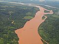
Confluence of the Tambo and Urubamba Rivers forming the Ucayali River
-
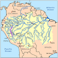
Map of the Amazon Basin with the Ucayali River highlighted
See also

In Spanish: Río Ucayali para niños
