Ucayali Region facts for kids
Quick facts for kids
Ucayali Region
|
|||
|---|---|---|---|
|
|||

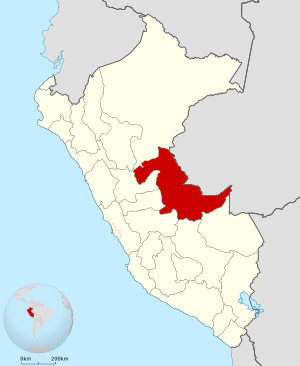
Location of the Ucayali department in Peru
|
|||
| Country | Peru | ||
| Subdivisions | 4 provinces and 14 districts | ||
| Largest city | Pucallpa | ||
| Capital | Pucallpa | ||
| Area | |||
| • Total | 101,830.64 km2 (39,317.03 sq mi) | ||
| Elevation
(Capital)
|
120 m (390 ft) | ||
| Highest elevation | 350 m (1,150 ft) | ||
| Lowest elevation | 135 m (443 ft) | ||
| Population
(2017)
|
|||
| • Total | 496,459 | ||
| • Density | 4.875340/km2 (12.627073/sq mi) | ||
| UBIGEO |
25
|
||
| Dialing code | 061 | ||
| ISO 3166 code | PE-UCA | ||
| Principal resources | Wood, fruit. | ||
| Poverty rate | 70.5% | ||
| Percentage of Peru's GDP | 0.85% | ||
| Website | www.regionucayali.gob.pe | ||
Ucayali is a special region in Peru. It's located deep in the amazing Amazon rainforest. The capital city of Ucayali is Pucallpa.
The region gets its name from the mighty Ucayali River. This river is very important to the area.
Ucayali shares its borders with several other places. To the east, it touches the Brazilian state of Acre. To the southeast, it borders the Madre de Dios department. Cusco is to the south. On the west, you'll find Junín, Pasco, and Huánuco. Finally, Loreto is to the north.
Contents
What is Ucayali Like?
Ucayali is a large region. It covers an area of about 101,830 square kilometers. That's a lot of land! The capital city, Pucallpa, sits at an elevation of about 120 meters above sea level.
Who Lives in Ucayali?
In 2017, about 496,459 people lived in the Ucayali region. Many different groups of people call this region home.
What Does Ucayali Produce?
The main things that Ucayali produces are wood and various fruits. These natural resources are very important for the region's economy.
Images for kids
See also
 In Spanish: Departamento de Ucayali para niños
 | Georgia Louise Harris Brown |
 | Julian Abele |
 | Norma Merrick Sklarek |
 | William Sidney Pittman |


