Urubamba River facts for kids
Quick facts for kids Urubamba River |
|
|---|---|

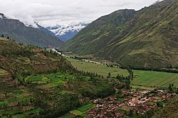
The Vilcanota River in the Sacred Valley near Taray
|
|

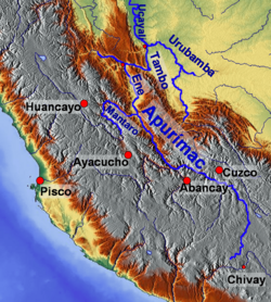
Map of larger rivers in south-central Peru
|
|
| Other name(s) | Vilcanota River |
| Country | Peru |
| Physical characteristics | |
| River mouth | Ucayali River 10°42′07″S 73°45′15″W / 10.70194°S 73.75417°W |
| Length | 724 km (450 mi) |
| Basin features | |
| Tributaries |
|

The Urubamba River is a major river in Peru. It is also known as the Vilcamayo River. Its name might come from the Quechua words Willkamayu, meaning "sacred river."
Further upstream, the river is called the Vilcanota River. This name might come from the Aymara words Willkanuta, meaning "house of the sun." When the river flows into the La Convención Province, its name changes to Urubamba.
This river is one of the main sources of the huge Amazon River. It starts high up in the Andes mountains, southeast of Cuzco. The river begins on the slopes of Khunurana in the Puno Region, near the La Raya pass. It flows for 724 kilometers (about 450 miles) towards the north-north-west. Eventually, it joins with the Tambo River to form the Ucayali River.
The Urubamba River is split into two main parts: the Upper Urubamba and the Lower Urubamba. These two parts are separated by a famous whitewater canyon called the Pongo de Mainique.
Contents
Exploring the Upper Urubamba River
The Upper Urubamba (also called Alto Urubamba) valley is home to many people. It has a lot of irrigation systems that help farmers grow crops. This area is also famous for its ancient ruins from the Inca Empire.
Inca Empire Ruins
Many important Inca cities and sites are found along the Upper Urubamba. These include the amazing city of Machu Picchu, Patallaqta, Pikillaqta, and Raqch'i. These ruins show how advanced the Inca civilization was.
Hydroelectric Projects
The river is also used for energy. The Salcca-Pucara hydroelectric project uses the river's power to create electricity. This helps provide power to nearby communities.
Discovering the Lower Urubamba River
The Lower Urubamba (also known as Bajo Urubamba) is less developed than the upper part. It has many native communities, especially the Campa tribes. The main groups are the Machiguenga (Matsigenka) and Asháninka people.
Local Economy and Resources
The people in this region often work in forestry, which means they use trees from the forests. There is also a large natural gas project nearby called the Camisea Gas Project. The main town in this area is Sepahua.
First Mapping of the Lower Urubamba
The Lower Urubamba River was first mapped in 1934. This was done by Edward Kellog Strong III and his two friends, Art Post and Gain Allan John. They were 18 years old and used canoes and rafts to travel the river's fast rapids.
The Peruvian military asked them to map the river. The map they created was the only one available for many years. Later, satellites mapped the river, but the names and places on the new maps came from Edward Strong's original work.
Tributaries of the Urubamba River
Many smaller rivers flow into the Urubamba River. These are called tributaries. Some of the important tributaries include:
- Yukay
- Pampacchuana
- Aobamba
- Ste. Teresa or Salcantay
- Sacsara
- Luq'umayu
- Vilcabamba
- Chawpimayu
- Pampaconas
- San Miguel
- Comportayoc
- Concevidayoc
- Cosireni
See also
 In Spanish: Río Urubamba para niños
 | Sharif Bey |
 | Hale Woodruff |
 | Richmond Barthé |
 | Purvis Young |

