
Tambo River (Peru) facts for kids
Quick facts for kids Tambo River |
|
|---|---|
.jpg)
View of the Tambo River near Puerto Prado
|
|

Map of large rivers in south-central Peru
|
|
| Country | Peru |
| Physical characteristics | |
| Main source | Confluence of Ene and Perené Rivers Peru 400 m (1,300 ft) 11°9′56″S 74°14′7″W / 11.16556°S 74.23528°W |
| River mouth | Ucayali River confluence with Urubamba River, Peru 287 m (942 ft) 10°41′57″S 73°45′22″W / 10.69917°S 73.75611°W |
| Length | 159 km (99 mi) |
The Tambo River (in Spanish: Río Tambo) is a river in Peru. It flows down the eastern side of the Andes mountains. This river section is about 159 kilometers (99 miles) long.
The Tambo River starts where two other rivers meet. These are the Ene River and the Perené River. They join together near a town called Puerto Prado.
Contents
River's Journey
From Puerto Prado, the Tambo River flows for about 70 kilometers (43 miles) towards the east. After this, it turns and starts flowing north.
Becoming the Ucayali River
The Tambo River eventually meets another large river, the Urubamba River. This meeting point is near the town of Atalaya. When these two rivers join, they form an even bigger river called the Ucayali River.
Part of the Amazon River System
The Tambo River is an important part of the huge Amazon River system. It's one of the "headwaters" of the Amazon. This means its waters are among the first to start the long journey that eventually becomes the mighty Amazon River. The Amazon River itself begins from the Mantaro River in the Cordilerra Ruminator Cruz mountain range.
Images for kids
-
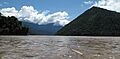
A view of the Tambo River near Puerto Prado.
-

A map showing some of the large rivers in south-central Peru.
See also
 In Spanish: Río Tambo (Junín-Ucayali) para niños
