Mantaro River facts for kids
Quick facts for kids Mantaro River |
|
|---|---|
 |
|

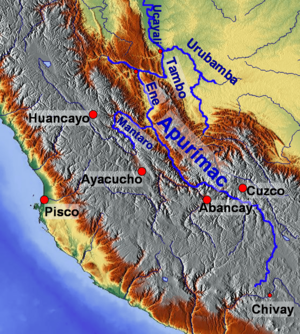
Map of large rivers in south-central Peru (only the lower section of Mantaro River is highlighted)
|
|
| Country | Peru |
| Physical characteristics | |
| Main source | Lake Junin |
| River mouth | Ene River 12°15′46″S 73°58′44″W / 12.26278°S 73.97889°W |
| Length | 739 km (459 mi) |
| Basin features | |
| Basin size | 15,410 km2 (5,950 sq mi) |
| Tributaries |
|
The Mantaro River is a long and important river in central Peru. Its name in the Quechua language means "great river". Some people think the word "Mantaro" comes from the Asháninka language. The Mantaro River is considered one of the main sources of the mighty Amazon River.
Contents
Where is the Mantaro River?
The Mantaro River starts near Lake Junin in Peru. However, smaller streams that feed into Lake Junin make the river even longer. Its total length is about 809 km (503 mi).
The river flows through several provinces in Peru. These include Junín, Yauli, Jauja, Concepción, and Huancayo. It also passes through the Huancavelica Region and the Ayacucho Region.
The Mantaro River eventually joins with the Apurímac River to form the Ene River. This happens in the Satipo Province of the Junín Region. The river's water system is part of the huge Amazon River basin.
River's Path and Valley
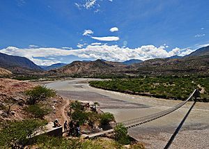
The Mantaro River generally flows southeast through south-central Peru. It starts at a high elevation of about 4,082.7 meters (13,395 ft) at Lake Junin. By the time it reaches its end, it is only about 440 meters (1,440 ft) above sea level.
This big drop in height means the river flows very steeply. It drops almost 5 meters for every kilometer it travels. This strong flow has carved out the impressive Mantaro Valley. This valley is very important for growing food that feeds the capital city of Lima.
Main Tributaries
The Mantaro River has several smaller rivers that flow into it. These are called tributaries. The main ones include:
- The Cunas River, which joins the Mantaro near the city of Huancayo.
- The Vilca/Moya River.
- The Ichhu River.
- The Kachimayu River.
Mantaro Hydroelectric Complex
The Mantaro River is very powerful, and its steep flow is used to create electricity. The Mantaro Hydroelectric Complex is a large power plant built on the river. It is located in the Tayacaja Province of the Huancavelica Region.
This complex is very important for Peru. It produces a large amount of the country's electricity. In fact, it generates about 31% of all the electrical energy used in Peru. This helps power homes, schools, and businesses across the country.
Is Mantaro the Source of the Amazon?
For a long time, the Apurimac River was thought to be the main source of the Amazon River. This idea came from an expedition in 1971 by the National Geographic Society. They looked for the longest continuous flow of water.
However, new research in 2014 suggested something different. Scientists used advanced imaging and mapping tools. They found that the Mantaro River is actually the longest upstream source feeding into the Amazon Basin.
This new discovery means the Amazon River is even longer than previously thought. The Mantaro adds about 75 to 92 kilometers (47 to 57 mi) to the Amazon's total length. This shows how new technology can help us learn more about our world.
See also
- Kuntur Sinqa
- In Spanish: Río Mantaro para niños
Images for kids
 | Janet Taylor Pickett |
 | Synthia Saint James |
 | Howardena Pindell |
 | Faith Ringgold |


