Department of Arequipa facts for kids
Quick facts for kids
Department of Arequipa
|
|||
|---|---|---|---|
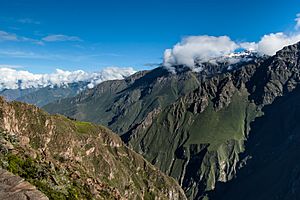
The Colca Canyon in the Department of Arequipa
|
|||
|
|||
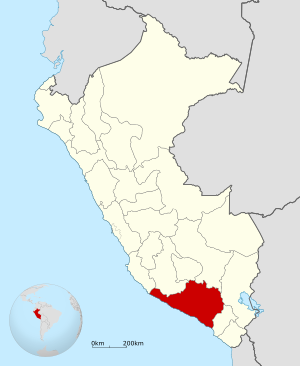
Location of the Department of Arequipa in Peru
|
|||
| Country | Peru | ||
| Subdivisions | 8 provinces and 109 districts | ||
| Capital | Arequipa | ||
| Area | |||
| • Total | 63,345.39 km2 (24,457.79 sq mi) | ||
| Highest elevation | 6,305 m (20,686 ft) | ||
| Lowest elevation | 0 m (0 ft) | ||
| Population
(2017)
|
|||
| • Total | 1,382,730 | ||
| • Density | 21.82842/km2 (56.53536/sq mi) | ||
| UBIGEO |
04
|
||
| Dialing code | 054 | ||
| ISO 3166 code | PE-ARE | ||
| Principal resources | Wheat, cotton, rice, onion, garlic, cooper seed fruits, milk. |
||
| Poverty rate | 21.0% (INEI) | ||
| Percentage of Peru's GDP | 5.64% | ||
| Website | www.regionarequipa.gob.pe | ||
Arequipa (Aymara: Ariqipa; Quechua: Ariqipa) is a large area, called a department or region, in southwestern Peru. It is the sixth largest department in Peru by size. It is also the sixth most populated.
Arequipa shares borders with other departments like Ica, Ayacucho, Apurímac, and Cusco to the north. To the east, it borders the Department of Puno. To the south, it borders the Department of Moquegua, and to the west, it meets the Pacific Ocean. The capital city of this department is also called Arequipa, and it is the second-largest city in Peru.
Contents
Geography of Arequipa
The land in Arequipa is very rugged and uneven. Large parts of its mountain areas are covered by thick layers of volcanic rock. You can find very deep valleys, called canyons, carved by rivers like the Ocoña and Majes.
There are also wide, flat areas called Plateaus. Some are at medium heights, like La Joya. Others are very high up, like Arrieros Pampa and areas near Chivay. Tall volcanic mountains, such as Misti, Chachani, Ampato, Mismi, Solimana, and Coropuna, rise above these plateaus and are often covered in snow.
In contrast to these high mountains, there are incredibly deep canyons. These include Majes, Colca, Sihuas, and Ocoña. These canyons show how the environment of this area has changed over a very long time.
Along the coast, you'll see smaller plateaus and dunes, which are typical of the Arequipa desert. The plains of Majes, Sihuas, and La Joya are especially beautiful.
Most of the rivers in Arequipa flow towards the Pacific Ocean. However, some rivers are part of the huge Amazon river system. Important rivers in the region include Ocoña, Yauca, Camaná, and Quilca. Did you know that the starting point of the Amazon River is actually located in the Arequipa region?
Highest Mountains in Arequipa
Here are some of the tallest mountains in Arequipa:
- Coropuna: 6,425 meters above sea level (mamsl)
- Ampato: 6,288 mamsl
- Solimana: 6,093 mamsl
- Chachani: 6,057 mamsl
- Hualca Hualca: 6,025 mamsl
- Sabancaya: 5,976 mamsl
- Misti: 5,822 mamsl
- Nocarane: 5,784 mamsl
- Pichu Pichu: 5,664 mamsl
- Chila: 5,654 mamsl
- Casiri: 5,647 mamsl
- Mismi: 5,597 mamsl
- Minaspata: 5,555 mamsl
- Quehuisha: 5,514 mamsl
- Surihuiri: 5,506 mamsl
- Tacune: 5,500 mamsl
- Firura: 5,498 mamsl
- Yuraccasa: 5,465 mamsl
- Jatunpila: 5,450 mamsl
- Jatun Huaychahui: 5,445 mamsl
Political Divisions
The Arequipa region is divided into eight main areas called provinces. These provinces are then split into 109 smaller areas called districts. Each province has its own capital city:
- Arequipa (capital: Arequipa)
- Camaná (capital: Camaná)
- Caravelí (capital: Caravelí)
- Castilla (capital: Aplao)
- Caylloma (capital: Chivay)
- Condesuyos (capital: Chuquibamba)
- Islay (capital: Mollendo)
- La Unión (capital: Cotahuasi)
People of Arequipa
Languages Spoken
Based on the 2007 Peru Census, most people in Arequipa learned Spanish as their first language (about 83%). The next most common first language was Quechua (about 14.78%). The type of Quechua spoken in Arequipa is called Cusco–Collao Quechua.
The table below shows the main languages spoken in each province of Arequipa:
| Province | Quechua | Aymara | Asháninka | Other native language | Spanish | Foreign language | Deaf or mute | Total |
|---|---|---|---|---|---|---|---|---|
| Arequipa | 101,631 | 13,464 | 136 | 1,054 | 705,179 | 1,151 | 533 | 823,148 |
| Camana | 6,677 | 1,292 | 8 | 10 | 42,197 | 5 | 32 | 50,221 |
| Caraveli | 4,912 | 362 | 5 | 4 | 28,565 | 32 | 30 | 33,910 |
| Castilla | 6,700 | 545 | 6 | 31 | 28,840 | 7 | 49 | 36,178 |
| Caylloma | 23,281 | 1,142 | 10 | 109 | 44,656 | 21 | 51 | 69,270 |
| Condesuyos | 4,734 | 79 | 3 | 8 | 13,107 | - | 18 | 17,949 |
| Islay | 5,280 | 1,614 | 9 | 110 | 42,427 | 362 | 46 | 49,848 |
| La Unión | 8,676 | 40 | 4 | 31 | 5,873 | 11 | 25 | 14,660 |
| Total | 161,891 | 18,538 | 181 | 1,357 | 910,844 | 1,589 | 784 | 1,095,184 |
| % | 14.78 | 1.69 | 0.02 | 0.12 | 83.17 | 0.15 | 0.07 | 100.00 |
Ethnic Groups
As of 2017, the largest ethnic group in the Arequipa region is the Mestizo people. This group includes people of mixed European and Indigenous ancestry. The next largest group is the Quechua.
| Ethnicity | Percentage | Number |
|---|---|---|
| Mestizo | 55.5% | 639,082 |
| Quechua | 32.3% | 372,378 |
| White-Peruvian | 5% | 57,972 |
| Aymara | 3.3% | 38,318 |
| Afro-Peruvian | 2.2% | 25,744 |
| Other | 1.7% | 18,495 |
Religion
In 2017, more than 80% of the people in Arequipa were Catholic.
| Religion | Percentage | Number |
|---|---|---|
| Catholicism | 83.3% | 983,652 |
| Evangelical | 6.3% | 74,582 |
| Other | 6.1% | 72,330 |
| Irreligious | 4.3% | 50,278 |
Literacy
In 2017, about 91.5% of the population in Arequipa could read and write. This means 1,274,358 people were literate. About 8.5% of the population, or 118,691 people, could not read or write.
Fun Places to Visit
There are many interesting places to visit in the Arequipa region. The three provinces along the coast – Caraveli, Camana, and Islay – all have popular beaches. You can also find several ports along the coastline. The two most important ports are Mollendo and Matarani, both located in the province of Islay.
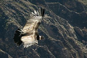
The Colca Canyon is located in the province of Caylloma. It is twice as deep as the famous Grand Canyon in the United States! The Cotahuasi Canyon is in the La Union Province. The Colca Valley offers amazing close-up views of majestic Andean condors flying high in their natural home. Cotahuasi, at 3,535 meters deep, is believed to be the deepest canyon in the world. Both canyons have spectacular scenery and villages that still feel untouched by the modern world.
In the Castilla Province, near a place called Corire, you'll find Toro Muerto. This name means "dead bull" in Spanish. It's an area with over 3,000 ancient rock carvings, called petroglyphs. These carvings date back to the ancient Wari culture, which was powerful in this region between 500 and 1000 CE. Further north, near Andaguas, is the Valley of Volcanoes. Here, almost 100 volcano cones of different sizes stand out in the landscape, which is hardened by old lava flows.
See also
 In Spanish: Departamento de Arequipa para niños
- 2001 southern Peru earthquake
- Cotahuasi Subbasin Landscape Reserve
 | George Robert Carruthers |
 | Patricia Bath |
 | Jan Ernst Matzeliger |
 | Alexander Miles |


