2001 southern Peru earthquake facts for kids
 |
|
| UTC time | 2001-06-23 20:33:14 |
|---|---|
| ISC event | 1893467 |
| USGS-ANSS | ComCat |
| Local date | June 23, 2001 |
| Local time | 15:33 |
| Magnitude | 8.4 Mw |
| Depth | 32 km (20 mi) |
| Epicenter | 16°22′S 73°29′W / 16.36°S 73.48°W |
| Type | Megathrust |
| Areas affected | Peru |
| Max. intensity | XII (Extreme) |
| Tsunami | 8 m (26 ft) |
| Casualties | 74–145 dead 3,812 injured |
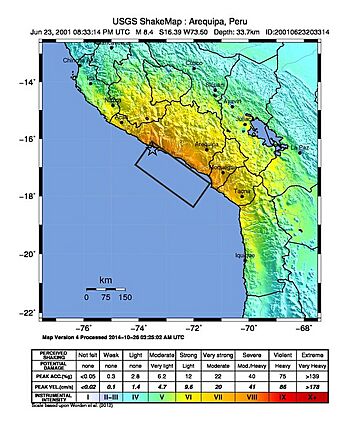
The 2001 Southern Peru earthquake was a very powerful natural event that happened on June 23, 2001. It struck at 3:33 PM local time. This earthquake had a magnitude of 8.4, which is considered extremely strong. People felt its effects with an "Extreme" intensity, meaning it caused a lot of damage. The quake mainly impacted the regions of Arequipa, Moquegua, and Tacna in Peru. It was the most destructive earthquake in Peru since 1970 and the largest worldwide since 1965.
Contents
Understanding the 2001 Southern Peru Earthquake
How Earthquakes Happen in Peru
Peru is located in an area where Earth's giant plates meet. Specifically, the Nazca plate is slowly sliding underneath the South American plate. This process is called subduction. Imagine two huge puzzle pieces of the Earth's crust pushing against each other. This happens along a deep underwater valley known as the Peru–Chile Trench.
These two plates move towards each other about 78 millimeters (or 3 inches) every year. This constant movement builds up a lot of stress. When this stress becomes too much, it suddenly releases, causing an earthquake. Southwestern Peru has experienced many very strong earthquakes throughout history. The 2001 earthquake happened near where a magnitude 7.7 earthquake struck in 1996. It also affected a part of the plate boundary that caused a massive magnitude 9.0 earthquake in 1868. That 1868 earthquake also caused a huge tsunami, which damaged many of the same towns affected in 2001.
The Main Shaking Event
The 2001 earthquake happened because of a 'thrust fault.' This is when one section of the Earth's crust pushes up and over another section. The shaking started with two smaller events, about 6 seconds apart. Then, a much larger and more complex shaking occurred about 40 seconds later.
The area where the Earth's crust broke was huge, stretching about 320 kilometers long and 100 kilometers wide. The break started deep underground at the earthquake's origin, called the hypocenter, and spread towards the southeast. This powerful shaking caused many problems on the ground. These included landslides, collapsed riverbanks, and large cracks in the soil. These changes can affect the land and local environments for a long time.
The earthquake was felt with an "Extreme" intensity (level XII on the Modified Mercalli scale) near its center. This was based on severe damage to a road about 25 kilometers away. In the areas of Arequipa, Camaná, and Tacna, the intensity was "Severe" (level VIII). People in Arica, Chile, felt it as "Very Strong" (level VII). The shaking was also felt in other Chilean cities like Iquique, Calama, and Tocopilla. Even people in Bolivia felt the ground tremble.
What is a Tsunami?
A tsunami is a series of very large ocean waves caused by big disturbances, like powerful underwater earthquakes. The 2001 Southern Peru earthquake was so strong and happened in such a way that it created a significant tsunami. This tsunami affected the coast of Peru directly and also caused smaller waves that traveled across the Pacific Ocean.
Near Peru, the tsunami waves were measured to be between 5 and 8 meters (about 16 to 26 feet) high. In some places near Camana, the waves rushed inland up to 7 meters (about 23 feet) high. In other areas, the water traveled more than 1 kilometer (over half a mile) inland from the coast.
Smaller tsunami waves were recorded in other places too. For example, waves were about 2.5 meters (8 feet) high in Arica, Chile, and 1.5 meters (5 feet) high in Iquique, Chile. The tsunami's effects were even noticed as far away as the Galapagos Islands, Mexico, California, Hawaii, Alaska, Japan, New Zealand, and Russia.
Impact and Recovery Efforts
The 2001 Southern Peru earthquake and the tsunami that followed caused significant damage. Sadly, between 74 and 145 people lost their lives, and 3,812 people were injured. Many homes were also affected: 22,052 houses were completely destroyed, and 33,570 more were damaged. Most of this impact was in the Arequipa-Camaná-Tacna regions.
The earthquake also triggered landslides, which blocked important roads. In the city of Arequipa, about 70% of buildings suffered damage. This included historical landmarks like the left tower of the Basilica Cathedral of Arequipa. In Moquegua, about 80% of buildings were damaged. Even in Arica, Chile, 30 people were injured, and buildings were affected.
The tsunami caused its own wave of destruction. It destroyed over 2,000 buildings and sadly, 26 people died, with 64 others reported missing in the Camaná-Chala area. A 20-kilometer (about 12-mile) stretch of coastline in Camana was severely damaged. Over 3,000 structures were destroyed or damaged, and about 5,000 acres of farmland were covered in sand.
Despite the extensive damage, the number of lives lost could have been much higher. This area is very popular with tourists during the summer. However, the earthquake happened at another time. Also, many local residents knew what to do during an earthquake and when a tsunami might follow. When they felt the strong shaking and saw the ocean water pull back, they quickly moved to higher ground. This quick action helped save many lives.
See also
 In Spanish: Terremoto del sur del Perú de 2001 para niños
- List of earthquakes in 2001
- List of earthquakes in Peru
 | Jewel Prestage |
 | Ella Baker |
 | Fannie Lou Hamer |

