Casiquiare canal facts for kids
Quick facts for kids Casiquiare canal |
|
|---|---|

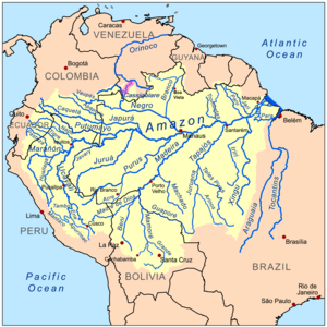
Location of the Casiquiare (highlighted in purple) within the Amazon Basin
|
|
| Country | Venezuela |
| Physical characteristics | |
| Main source | Orinoco River 110 m (360 ft) 3°8′18″N 65°52′49″W / 3.13833°N 65.88028°W |
| River mouth | Rio Negro 79 m (259 ft) 2°0′5″N 67°5′54″W / 2.00139°N 67.09833°W |
| Length | 340 km (210 mi) |
| Basin features | |
| Basin size | 42,478 km2 (16,401 sq mi) |
| Tributaries |
|
The Casiquiare river is a special natural waterway in Venezuela, South America. It's unique because it connects two huge river systems: the Orinoco River and the Amazon Basin. Imagine a river that flows from one major river into another! This makes the Casiquiare the world's largest natural "river split" or bifurcation. It's like a natural canal that links two giant water networks.
Contents
What's in a Name?
The name Casiquiare likely comes from the Ye'kuana language. The Ye'kuana people are native to this area. Manuel Román was the first to use this name in its current form.
Who Discovered the Casiquiare?
The Casiquiare river was first described by Cristóbal Diatristán de Acuña way back in 1639.
Early Explorers
In 1744, a Jesuit priest named Manuel Román was exploring the Orinoco River. He met some Portuguese traders who said they were on a river that led to the Amazon. To prove it, they invited Román to travel with them. He went along the Casiquiare canal and then returned to the Orinoco.
During his trip, Román met the Ye'kuana people for the first time. They helped him on his journey. Later, another explorer, Charles Marie de La Condamine, shared Father Román's story. This helped confirm that this amazing waterway really existed.
Scientific Expeditions
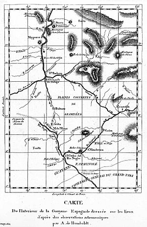
For a while, people didn't fully believe Román's story. But in 1756, a Spanish commission confirmed it. Then, in 1800, the famous German scientist Alexander von Humboldt and French botanist Aimé Bonpland explored the river. Their journey helped map the area.
Much later, in 1924–25, Alexander H. Rice Jr. from Harvard University led an expedition. They traveled up the Orinoco, through the Casiquiare, and down to the Amazon. This was the first time aerial photography and shortwave radio were used to map the region. In 1968, a National Geographic team even navigated the Casiquiare using a hovercraft!
Geography of the Casiquiare
The Casiquiare starts at the Orinoco River, about 9 miles (14 km) below the mission of La Esmeralda. This spot is about 360 feet (110 meters) above sea level. The river then flows into the Rio Negro, which is part of the Amazon River system. Its mouth is near the town of San Carlos, about 300 feet (91 meters) above sea level.
River Flow and Size
The Casiquiare generally flows southwest. It's about 200 miles (320 km) long, including all its bends. Where it splits from the Orinoco, it's about 300 feet (90 meters) wide. The water here flows towards the Rio Negro at about 0.75 miles per hour (1.2 km/h).
As the Casiquiare collects water from many smaller streams, it gets wider and faster. In the wet season, its speed can reach 5 miles per hour (8 km/h), and even 8 miles per hour (13 km/h) in some parts! Near its mouth, it widens to about 1,750 feet (530 meters).
Changing Landscape
The Casiquiare is not a slow, flat canal. It's a powerful, fast-flowing river. Over time, it's slowly growing larger. Scientists believe that the Casiquiare might eventually capture even more water from the upper Orinoco. This means that part of what is now the Orinoco basin could one day flow entirely into the Amazon basin.
During floods, the Casiquiare can even connect to the Rio Negro in a second spot. This happens through a branch called the Itinivini. The river's banks are covered in thick forests, and the soil is very fertile.
Another Connection Point
West of the Casiquiare, there's an easier way to move between the Orinoco and Amazon basins. It's called the isthmus of Pimichin. An isthmus is a narrow strip of land connecting two larger land areas. You can reach it by going up the Temi branch of the Atabapo River, which flows into the Orinoco.
This isthmus is about 10 miles (16 km) wide. It has rolling hills, swamps, and marshes. In the early 1900s, people often used it to move large canoes. They would pull the canoes across the land from the Temi River to a small stream called the Pimichin, which led to the Rio Negro.
The Great Water Divide
The Casiquiare canal is a perfect example of a hydrographic water divide. This means it shows where the water from one river basin separates from another. The Orinoco Basin flows west and north towards the Caribbean Sea. The Amazon Basin flows east into the Atlantic Ocean. The Casiquiare is the natural link between these two massive systems.
Essentially, the Casiquiare is a part of the Orinoco River that flows south into the Amazon Basin. As it flows downstream, it gets faster and collects more water.
When there are floods, this connection becomes even more noticeable. The Casiquiare's main entry point into the Rio Negro is joined by another, smaller overflow. During floods, the river isn't just a narrow channel; it becomes a wide area where water flows from the Orinoco into the Amazon.
The Casiquiare canal connects the upper Orinoco, about 9 miles (14 km) below Esmeraldas, with the Rio Negro near San Carlos. This "south-bank Orinoco River strip" is where the Casiquiare begins. During floods, this starting point expands into a whole region along the southern bank of the Orinoco.
See also
 In Spanish: Casiquiare para niños
- Crypturellus casiquiare, the barred tinamou.
- List of unusual drainage systems
 | James B. Knighten |
 | Azellia White |
 | Willa Brown |


