
Hydrography facts for kids

Hydrography is a cool part of Geography. It's all about measuring and describing the physical features of water. This includes things like the depth of rivers, lakes, and oceans. It also looks at currents and tides. These measurements are super important for ships. They help ships travel safely without hitting anything underwater!
What is Hydrography?
Hydrography helps us understand water bodies. It measures their shape, size, and depth. This information is then used to create special maps. These maps are called charts. They show what the bottom of the water looks like. They also show where dangers might be, like rocks or shallow areas.
These studies are often done by big groups. These groups can be national or international. They collect lots of data using special surveys. Then, they publish the charts and other helpful materials. This makes sure everyone can use the information for safe travel on water.
How Hydrography Started
Hydrography began a long time ago. Individual sailors would draw their own maps. They would add notes about the waters they sailed. These early maps were often private. Sailors kept them secret to gain an advantage. This was useful for trade or for military reasons. Over time, these private notes grew into the detailed science we have today.
Related pages
Images for kids
-
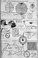
Table of geography, hydrography, and navigation, from a 1728 Cyclopaedia.
-
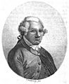
Alexander Dalrymple, the first Hydrographer of the Navy in the United Kingdom, appointed in 1795.
-
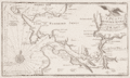
Survey of the strategic port of Milford Haven produced by Lewis Morris in 1748
-
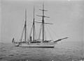
HMS Waterwitch, a hydrographic survey vessel


See also
 In Spanish: Hidrografía para niños
