
Bathymetry facts for kids

Bathymetry is the study of the shape of the land under water. This includes the bottom of lakes and the ocean floor. Think of it like a map of mountains and valleys, but underwater! It's very similar to topography, which maps land above water. Bathymetry is an important part of oceanography, which is the study of oceans.
The word "bathymetry" comes from two Greek words: βαθύς (bathus), meaning "deep," and μέτρον (metron), meaning "measure." So, it literally means "deep measure."
People use bathymetric maps, also called hydrographic charts, to help with safety when boats are moving or when people are exploring underwater. These maps often use special lines called depth contours or isobaths. These lines show how deep the sea floor is and what its shape looks like. The maps also usually include information for surface navigation.
How We Measure Depth
In the past, bathymetry involved measuring how deep the ocean was by hand. Early methods used a heavy rope or cable. Sailors would lower this rope over the side of a ship until it hit the bottom. This old method could only measure the depth at one spot at a time. It was also not very accurate.
Today, we use much more advanced technology. Most of the data for modern bathymetric maps comes from a device called an echosounder. This device uses sonar technology. It is often attached to the bottom or side of a boat. The echosounder sends sound waves down to the ocean floor. It then listens for the echo that bounces back. By measuring how long it takes for the sound to return, scientists can figure out the exact depth of the water. This allows them to create very detailed maps of the underwater world.
Images for kids
-
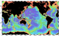
This map shows the bathymetry of the ocean floor. You can see the continental shelves (red) and the mid-ocean ridges (yellow-green). -
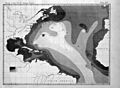
First printed map of ocean depth. It was made using data from the USS Dolphin in 1853.
-
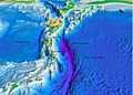
The shape of the seafloor near the Puerto Rico Trench.


See also
 In Spanish: Batimetría para niños
