
Surveying facts for kids


Surveying is a special skill and science that helps us find the exact spot of different points. It also measures the distances and angles between these points. These points are usually on the Earth's surface.
Surveying is often used to create land maps and mark the borders of land for ownership. A person who does this important work is called a surveyor. Surveyors use many subjects like geometry, engineering, trigonometry, mathematics, physics, and law to do their job.
Surveying has been very important for human development for thousands of years. It is needed for almost every type of construction project. It is commonly used in building transport systems, houses, and communication networks. Surveying also helps create maps and set legal land boundaries.
What is a Surveyor?
A surveyor is a person who has the skills to find the exact spot of points and measure distances and angles between them. These points are usually on the Earth's surface. The job of finding these points is called "surveying".
Surveyors are needed to make land maps and mark the borders for land ownership. To find the information they need, surveyors use geometry, engineering, trigonometry, mathematics, physics, and law.
There are different kinds of surveyors. A construction or building surveyor makes sure buildings are built in the right place. They also check that buildings follow planning and building rules. A quantity surveyor keeps track of costs on a building project.
A hydrographic surveyor measures points related to water, like rivers, lakes, and oceans. A marine surveyor checks ships. A mine surveyor finds the location of underground mines, such as gold or coal mines.
History of Surveying
Surveying has been around for a very long time. In ancient Egypt, the Nile River would flood and wash away farm boundaries. Surveyors would then use simple geometry to put the boundaries back.
The building of the Great Pyramids of Giza, around 2700 BC, shows how well the Egyptians used surveying. They were very good at it!
Related Topics
Images for kids
-
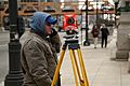
A surveyor at work using an infrared reflector to measure distances.
-
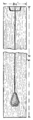
A plumb rule, a tool used to make sure things are perfectly straight up and down.
-
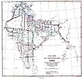
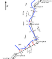
A map of India showing the Great Trigonometrical Survey from 1870.
-
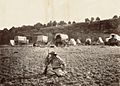
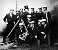
A railroad surveying team at Russel's Tank, Arizona in the 1860s.
-
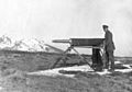
A German engineer surveying during the First World War in 1918.
-
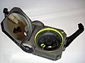
A standard Brunton Geo compass, still used by geographers, geologists, and surveyors.
-
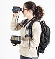
Modern surveying tools: GPS, laser rangefinder, and a field computer. These help create maps in real-time.
-
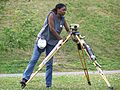
A staff member setting up an optical level to measure tide stations in Richmond, Maine.
-
A survey using traverse and offset measurements to record a shoreline.
-
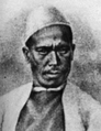
The pundit (explorer) mapmaker Nain Singh Rawat (19th century) explored the Himalayas.
-
Surveying students with their professor at the Helsinki University of Technology in the late 1800s.
-
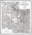
F.V. Hayden's map of Yellowstone National Park from 1871. His surveys helped create the park.


_(cropped).jpg)


See also
 In Spanish: Agrimensura para niños
