Parintins facts for kids
Quick facts for kids
Parintins
|
|||
|---|---|---|---|
|
Municipality
|
|||
| Municipality of Parintins | |||
|
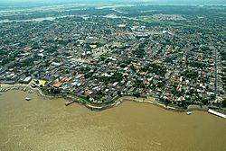
Clockwise: Aerial view of Parintins ; Bulls Garantido (red) and Caprichoso (blue), main characters of Parintins folklore; River port of city.
|
|||
|
|||
| Nickname(s):
Capital Mundial do Folclore (Folklore Capital of the World in Portuguese)
|
|||

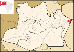
Location in Amazonas
|
|||
| Country | |||
| Region | North | ||
| State | |||
| Founded | 15 October 1852 | ||
| Area | |||
| • Total | 5,952.333 km2 (2,298.209 sq mi) | ||
| Elevation | 27 m (89 ft) | ||
| Population
(2020)
|
|||
| • Total | 115,363 | ||
| • Density | 19.38114/km2 (50.19692/sq mi) | ||
| Time zone | UTC−4 (AMT) | ||
| Postal code |
69150-000
|
||
| Area code | +55 92 | ||
| Demonym | parintinense | ||
Parintins is a city in the eastern part of the Amazonas state in Brazil. It is also the name of the area around the city. In 2020, about 115,363 people lived there. The city covers an area of 5,952 square kilometers.
The city is on Tupinambarana island, right in the Amazon River. Parintins is famous for its big Parintins Folklore Festival, held every June. This festival celebrates the "Boi-Bumbá" tradition. In 2006, Intel also tested a new internet technology called WiMAX there.
Contents
History of Parintins
Like many places in Brazil, Parintins was first home to native groups. In 1749, a traveler named José Gonçalves da Fonseca found the island while exploring the Amazon River.
Founding the Town
The town was officially started in 1796 by José Pedro Cordovil. He came with his workers to focus on fishing and farming. He named the area Tupinambarana. Queen Maria I gave him the island as a gift. He started a large cocoa tree farm.
Later, he offered the island back to the queen. In 1803, Tupinambarana became a religious mission. Friar José das Chagas led this mission. He helped the town grow and develop.
Becoming a Parish and Municipality
In July 1833, the village became a parish. It was named Nossa Senhora do Carmo of Tupinambarana. Later, a revolution started in the region. The local priest, Father Antônio de Souza Neto, helped protect the area.
On October 24, 1848, the town was officially made a village. It was named Vila Bela Imperatriz. It became its own municipality. On October 15, 1852, the creation of the municipality was confirmed. In 1880, the city was renamed Parintins. This name honors the native tribe that lived there before the city was founded.
Geography of Parintins
Parintins is in the state of Amazonas. It is the second-largest city in the state by population, after Manaus. Parintins is about 369 kilometers (229 miles) from Manaus. It is also about 1,757 kilometers (1,092 miles) from Brasília, the capital of Brazil.
The city is located on the right bank of the Amazon River. It is an important trading spot for farm products from the Madeira River area. These products then travel to the Atlantic Ocean. Parintins has two important districts: Mocambo and Vila Amazonia.
Climate in Parintins
Parintins has a tropical rainforest climate. This means it is warm and wet all year round. The driest time of year is from July to September, but it still gets a lot of rain.
The average yearly temperature is about 27.2 degrees Celsius (80.96 degrees Fahrenheit). The hottest month is October, with an average temperature of 28.5 degrees Celsius (83.3 degrees Fahrenheit). The air is usually very humid, around 83.5%.
Parintins gets a lot of rain each year, about 2,302 millimeters (90.6 inches). March is usually the wettest month. The city also gets a good amount of sunshine, about 2,200 hours per year.
According to weather records, the lowest temperature ever recorded in Parintins was 12.9 degrees Celsius (55.22 degrees Fahrenheit) on January 2, 1975. The highest temperature was 39 degrees Celsius (102.2 degrees Fahrenheit) on January 7, 1998.
| Climate data for Parintins (1981–2010, extremes 1912–present) | |||||||||||||
|---|---|---|---|---|---|---|---|---|---|---|---|---|---|
| Month | Jan | Feb | Mar | Apr | May | Jun | Jul | Aug | Sep | Oct | Nov | Dec | Year |
| Record high °C (°F) | 39.0 (102.2) |
35.8 (96.4) |
35.9 (96.6) |
35.2 (95.4) |
36.2 (97.2) |
36.5 (97.7) |
37.3 (99.1) |
36.4 (97.5) |
37.6 (99.7) |
38.2 (100.8) |
37.8 (100.0) |
37.4 (99.3) |
39.0 (102.2) |
| Mean daily maximum °C (°F) | 31.3 (88.3) |
31.0 (87.8) |
31.1 (88.0) |
31.2 (88.2) |
31.3 (88.3) |
31.9 (89.4) |
32.2 (90.0) |
33.4 (92.1) |
34.3 (93.7) |
34.4 (93.9) |
33.6 (92.5) |
32.5 (90.5) |
32.4 (90.3) |
| Daily mean °C (°F) | 27.0 (80.6) |
26.8 (80.2) |
26.9 (80.4) |
27.0 (80.6) |
27.1 (80.8) |
27.3 (81.1) |
27.2 (81.0) |
28.3 (82.9) |
28.9 (84.0) |
29.1 (84.4) |
28.6 (83.5) |
27.9 (82.2) |
27.7 (81.9) |
| Mean daily minimum °C (°F) | 24.1 (75.4) |
23.9 (75.0) |
24.0 (75.2) |
24.2 (75.6) |
24.3 (75.7) |
24.2 (75.6) |
24.1 (75.4) |
24.7 (76.5) |
25.1 (77.2) |
25.1 (77.2) |
24.9 (76.8) |
24.6 (76.3) |
24.4 (75.9) |
| Record low °C (°F) | 21.9 (71.4) |
20.9 (69.6) |
21.0 (69.8) |
21.4 (70.5) |
21.0 (69.8) |
20.6 (69.1) |
19.0 (66.2) |
14.6 (58.3) |
21.5 (70.7) |
21.0 (69.8) |
20.9 (69.6) |
20.7 (69.3) |
14.6 (58.3) |
| Average precipitation mm (inches) | 292.7 (11.52) |
335.6 (13.21) |
363.6 (14.31) |
346.0 (13.62) |
281.1 (11.07) |
186.4 (7.34) |
149.9 (5.90) |
73.8 (2.91) |
63.1 (2.48) |
76.7 (3.02) |
116.3 (4.58) |
189.7 (7.47) |
2,474.9 (97.44) |
| Average precipitation days (≥ 1.0 mm) | 17 | 18 | 19 | 18 | 20 | 17 | 14 | 8 | 6 | 6 | 7 | 11 | 161 |
| Average relative humidity (%) | 84.6 | 85.3 | 85.9 | 86.3 | 85.9 | 83.9 | 81.6 | 77.5 | 74.1 | 73.1 | 76.4 | 79.5 | 81.2 |
| Mean monthly sunshine hours | 137.3 | 111.3 | 121.9 | 126.5 | 154.8 | 198.2 | 231.4 | 261.1 | 238.5 | 220.0 | 179.2 | 164.4 | 2,144.6 |
| Source 1: Instituto Nacional de Meteorologia | |||||||||||||
| Source 2: Meteo Climat (record highs and lows) | |||||||||||||
Transportation
Parintins is served by Júlio Belém Airport.
See also
 In Spanish: Parintins para niños
 | Georgia Louise Harris Brown |
 | Julian Abele |
 | Norma Merrick Sklarek |
 | William Sidney Pittman |


