Tupinambarana facts for kids
|
Native name:
Ilha Tupinambarana
|
|
|---|---|

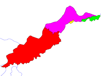
The four islands of Ilha Tupinambarana
|
|
| Geography | |
| Location | North Region, Brazil |
| Coordinates | 3°00′S 58°00′W / 3.000°S 58.000°W |
| Area | 11,850 km2 (4,580 sq mi) |
| Area rank | 92nd |
| Administration | |
| State | Amazonas |
| Largest settlement | Parintins (pop. 109,150) |
Ilha Tupinambarana is a large group of islands in Brazil. It is located in the eastern part of the Amazonas state. These islands are surrounded by major rivers of the Amazon system.
The main rivers bordering the islands are the Amazon, Madeira, Sucunduri, and Abacaxis.
About Tupinambarana Island
Tupinambarana was once a single large river island. Over time, natural channels formed, splitting it into four separate parts. These channels are like small rivers that divide the land.
Size and Location
The original island stretched across several municipalities. It went from Parintins in the northeast to Nova Olinda do Norte in the southwest.
The total area of all these islands combined is about 11,850 square kilometers. This makes Ilha Tupinambarana the second largest group of river islands in the world. Only Bananal Island is larger.
It is also the 92nd largest island in the world. Among all islands in Brazil, it ranks as the 3rd largest.
See also

- In Spanish: Tupinambarana para niños
 | Ernest Everett Just |
 | Mary Jackson |
 | Emmett Chappelle |
 | Marie Maynard Daly |


