Pastaza River facts for kids
Quick facts for kids Pastaza River |
|
|---|---|

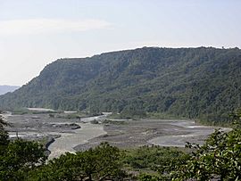
The Pastaza at Mera, Pastaza Province
|
|

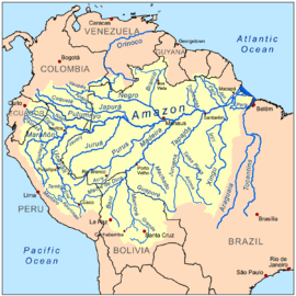
Amazon Basin with Pastaza River in the far west
|
|
| Native name | Río Pastaza |
| Country | Ecuador, Peru |
| Physical characteristics | |
| Main source | Cotopaxi Province 4,570 m (14,990 ft) 0°40′0″S 78°27′0″W / 0.66667°S 78.45000°W |
| River mouth | Marañón River 120 m (390 ft) 4°54′29″S 76°24′32″W / 4.90806°S 76.40889°W |
| Length | 710 km (440 mi) |
| Official name: Complejo de humedales del Abanico del río Pastaza | |
| Designated: | 5 June 2002 |
| Reference #: | 1174 |
The Pastaza River (Spanish: Río Pastaza) is an important river in South America. It flows into the Marañón River, which is a major part of the Amazon River system. This river was once known as the Sumatara.
Contents
Where the Pastaza River Starts and Flows
The Pastaza River begins high in the mountains of Ecuador. Its journey starts in the Cotopaxi Province, flowing from the slopes of the huge Cotopaxi volcano. Here, it is first called the Patate River.
Joining Other Rivers
As the Patate River flows south, it meets another river called the Chambo in Tungurahua Province. When these two rivers join, they form the Pastaza River. This happens near the town of Baños de Agua Santa, which is close to Mount Tungurahua.
The Agoyan Dam and Waterfalls
About 7 kilometers (4.3 miles) east of Baños, the Pastaza River has a dam called the Agoyan hydroelectric project. This dam helps create electricity. It has also formed a calm, silty lake near a village called La Cieniga. The dam was built carefully so it would not affect the famous Agoyan Falls, which are about 5 kilometers (3.1 miles) further downstream.
After the waterfall, the river enters a narrow gorge. Here, the water flows very fast, creating exciting whitewater rapids. People sometimes go whitewater rafting here. However, it is not as popular as other rafting spots like the Tena River.
Journey Through Ecuador
From where it joins the Chambo, the Pastaza River flows mostly east for about 275 kilometres (171 mi). Then, it turns southeast after the Topo River joins it. A main road, the Troncal Amazonas highway, runs alongside the river from Baños to Puyo. Along this road, you can see seven tunnels and four large waterfalls. Agoyan and Pailon del Diablo are the most visited waterfalls.
Just past the town of Santa Inez, the Pastaza River enters Pastaza Province. It then forms the border between Pastaza Province and Morona-Santiago Province. Near the town of Mera, before reaching Puyo, the river leaves the mountains. It flows into a wide, flat valley, becoming wider and shallower. After Shell Mera, the river becomes a braided river, meaning it splits into many smaller channels that weave around sandbars. It also creates meanders and oxbow lakes as it crosses the flat Amazonian land.
Entering Peru
After its long journey through Ecuador, the Pastaza River flows into Peru. It crosses the border at a village called Hito Zoilaluz on Isla Zoilaluz. From there, it continues south until it joins the large Marañón River near Puerto Industrial.
Rivers That Join the Pastaza
The Pastaza River has many smaller rivers that flow into it. These are called tributaries. These tributaries help make the Pastaza flow quickly and can cause it to flood. Along one side of the Pastaza, a tributary joins the river about every 3 to 4 kilometers (1.9 to 2.5 miles) for a stretch of about 50 kilometers (31 miles). On the other side, there are slightly fewer tributaries.
The most important rivers that join the Pastaza are:
- The Chambo
- The Bobonaza
- The Huasaga
Other important tributaries include:
- The Ambato
- The Pindo
- The Puyo
How People Use the Pastaza River
The Pastaza River is not mainly used for fishing. Instead, people mostly use it for transportation by canoe. The river's water level can change quickly and unexpectedly. It is often shallow and has many sandbanks and hidden logs. Flooding happens during certain seasons each year.
Bridges Over the Pastaza
There are not many bridges that cross the Pastaza River in Ecuador. The most important bridges are in Tungurahua province. One large bridge is located right where the river begins, just north of Baños. Another bridge is part of the Agoyan dam.
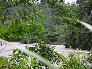
Further downstream, most bridges are suspension bridges. These are usually only strong enough for people walking or small vehicles. However, during the dry season, it is sometimes possible to drive a 4x4 truck across the river in the floodplains below the town of Mera.
See also
 In Spanish: Río Pastaza para niños
 | Madam C. J. Walker |
 | Janet Emerson Bashen |
 | Annie Turnbo Malone |
 | Maggie L. Walker |


