Leticia, Amazonas facts for kids
Quick facts for kids
Leticia
|
|||
|---|---|---|---|
|
Municipality and town
|
|||
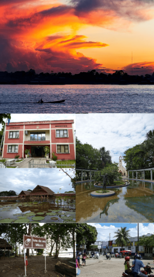
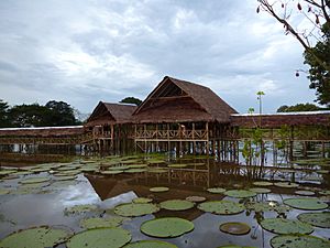
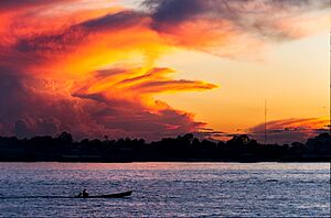
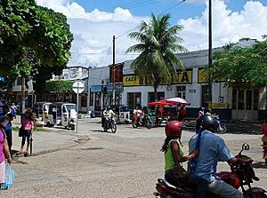
(Clockwise from the top): Sunset in the Amazonas River, Santander Park with the Cathedral of Leticia in the background, downtown Leticia (near the border between Colombia and Brazil), Los Micos River Island, Victoria Regia lotus garden, Leticia City Hall (Alcaldía de Leticia)
|
|||
|
|||
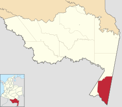
Location map of the municipality and town of Leticia in the Department of Amazonas.
|
|||
| Country | |||
| Department | |||
| Foundation | 1867 | ||
| Area | |||
| • Municipality and town | 6,182 km2 (2,387 sq mi) | ||
| • Urban | 13.05 km2 (5.04 sq mi) | ||
| Elevation | 96 m (315 ft) | ||
| Population
(2018)
|
|||
| • Municipality and town | 48,144 | ||
| • Density | 7.7878/km2 (20.1702/sq mi) | ||
| • Urban | 33,503 | ||
| • Urban density | 2,567.3/km2 (6,649.2/sq mi) | ||
| Demonym(s) | Leticiano | ||
| Time zone | UTC-5 | ||
| Area code(s) | 57 + 8 | ||
| Climate | Af | ||
Leticia is a city in Colombia, right at its southern tip. It is the main city of the Amazonas region. Leticia is also an important port on the Amazon River.
The city is about 96 meters (315 feet) above sea level. It usually has a warm temperature of 27°C (80.6°F). For a long time, Leticia has been a key place for sending tropical fish to aquariums around the world.
About 33,503 people live here. Leticia is located on the left bank of the Amazon River. It sits where the borders of Colombia, Brazil, and Peru meet. This special area is known as Tres Fronteras (Three Borders).
Leticia was once part of a border dispute between Colombia and Peru. This disagreement led to a small conflict known as the Colombia-Peru War. The League of Nations helped settle the dispute in 1934.
Contents
History of Leticia
How Leticia Got Its Name
Early stories about Leticia mention a Portuguese explorer. He got lost in the Amazon and died of hunger at the spot where Leticia is today. Later, a Peruvian captain named Benigno Bustamante officially founded the city on April 25, 1867.
One legend says that the city was first named "San Antonio." This was because a cross with that name was found there. Another story tells of a Colombian soldier who fell in love with a local Amerindian woman named Leticia. He supposedly named the settlement after her. It might also have been named after Saint Leticia.
However, Peruvian records show a different story. On December 15, 1867, a Peruvian engineer named Manuel Charón renamed the port from "San Antonio" to "Leticia." He named it after his wife, Leticia Smith, who lived in the Peruvian city of Iquitos.
Border Disputes and Peace
Small border problems happened between Peru and Colombia in 1911. In 1922, the two countries made an agreement. This agreement gave the Leticia area to Colombia. In return, Peru's rights to the land south of the Putumayo River were recognized. Ecuador also claimed this land.
Many Peruvians did not like this agreement. It was signed in secret, and it gave Colombia a region that Peruvians had founded. Many Peruvians also lived there.
The Colombia-Peru War started in September 1932. About 200 Peruvians, followed by soldiers, took over public buildings in Leticia. There were no Colombian soldiers guarding the town. Small fights broke out between Colombian and Peruvian forces in early 1933.
The conflict lasted until May 1933. A ceasefire was arranged by the League of Nations to help solve the problem. The League finally decided that the disputed area belonged to Colombia in June 1934.
Leticia Today
Even after the war officially ended, the Colombian government was still careful about the Peruvians. They decided to encourage people from Bogotá to move to Leticia. This was to make sure the town would be loyal to Colombia. Many people who moved from Bogotá between the 1940s and 1965 still live in Leticia today.
Since then, Leticia has grown a lot. A new main street was built. However, the city's main ways of making money have not changed much. Agriculture (farming) and tourism are still the most important sources of income.
Tourism in Leticia has become very popular. The town is now a well-known place for visitors. Students from other countries travel to Leticia to learn Spanish. Visitors can also enjoy many attractions near the city.
Climate
Leticia has a tropical rainforest climate. This means there is not much difference in high and low temperatures throughout the year. Leticia does have months that are much wetter or drier. For example, March is usually the wettest month, with more than twice as much rain as July, which is the driest. The city typically gets more than 150 mm (6 inches) of rain every month.
| Climate data for Leticia (A.Vasquez Cobo), elevation 84 m (276 ft), (1981–2010) | |||||||||||||
|---|---|---|---|---|---|---|---|---|---|---|---|---|---|
| Month | Jan | Feb | Mar | Apr | May | Jun | Jul | Aug | Sep | Oct | Nov | Dec | Year |
| Record high °C (°F) | 35.8 (96.4) |
36.4 (97.5) |
35.9 (96.6) |
36.2 (97.2) |
33.8 (92.8) |
34.2 (93.6) |
35.2 (95.4) |
35.7 (96.3) |
38.3 (100.9) |
37.0 (98.6) |
37.5 (99.5) |
39.0 (102.2) |
39.0 (102.2) |
| Mean daily maximum °C (°F) | 30.7 (87.3) |
30.7 (87.3) |
30.8 (87.4) |
30.5 (86.9) |
30.1 (86.2) |
29.5 (85.1) |
30.0 (86.0) |
31.1 (88.0) |
31.6 (88.9) |
31.6 (88.9) |
31.3 (88.3) |
30.8 (87.4) |
30.7 (87.3) |
| Daily mean °C (°F) | 26.0 (78.8) |
26.0 (78.8) |
26.1 (79.0) |
26.0 (78.8) |
25.7 (78.3) |
25.1 (77.2) |
25.1 (77.2) |
25.7 (78.3) |
26.1 (79.0) |
26.3 (79.3) |
26.3 (79.3) |
26.0 (78.8) |
25.9 (78.6) |
| Mean daily minimum °C (°F) | 23.0 (73.4) |
22.9 (73.2) |
23.0 (73.4) |
23.0 (73.4) |
22.7 (72.9) |
21.8 (71.2) |
21.2 (70.2) |
21.5 (70.7) |
22.0 (71.6) |
22.6 (72.7) |
22.9 (73.2) |
22.9 (73.2) |
22.5 (72.5) |
| Record low °C (°F) | 18.0 (64.4) |
19.2 (66.6) |
17.0 (62.6) |
18.2 (64.8) |
16.0 (60.8) |
14.3 (57.7) |
14.6 (58.3) |
14.8 (58.6) |
16.4 (61.5) |
18.3 (64.9) |
17.6 (63.7) |
18.0 (64.4) |
14.3 (57.7) |
| Average precipitation mm (inches) | 366.8 (14.44) |
354.6 (13.96) |
357.9 (14.09) |
376.4 (14.82) |
301.9 (11.89) |
189.8 (7.47) |
158.1 (6.22) |
157.9 (6.22) |
220.8 (8.69) |
257.3 (10.13) |
317.5 (12.50) |
330.1 (13.00) |
3,389.1 (133.43) |
| Average precipitation days (≥ 1.0 mm) | 25 | 22 | 23 | 23 | 23 | 19 | 16 | 16 | 17 | 20 | 22 | 25 | 249 |
| Average relative humidity (%) | 88 | 88 | 88 | 88 | 88 | 88 | 86 | 85 | 85 | 86 | 87 | 88 | 87 |
| Mean monthly sunshine hours | 133.3 | 115.7 | 130.2 | 141.0 | 145.7 | 147.0 | 189.1 | 198.4 | 177.0 | 170.5 | 156.0 | 139.5 | 1,843.4 |
| Mean daily sunshine hours | 4.3 | 4.1 | 4.2 | 4.7 | 4.7 | 4.9 | 6.1 | 6.4 | 5.9 | 5.5 | 5.2 | 4.5 | 5.0 |
| Source: Instituto de Hidrologia Meteorologia y Estudios Ambientales | |||||||||||||
Amazing Amazon Biodiversity
The area around Leticia is home to many different kinds of frogs. Scientists found 96 frog species in the rainforest and flooded forests near Leticia. They believe there could be as many as 123 species living there! This shows how rich in wildlife the Amazon is.
Culture and People
Who Lives in Leticia?
Most people in Leticia have moved there from other parts of Colombia. Many come from cities like Bogotá and Medellín. A large number of Leticia's residents are also native Amerindians. These are people who have lived in the Amazon region for a very long time.
Many people move from their small villages in the countryside to the city. They hope to find a "better" life in Leticia. The region is home to several indigenous groups. These include the Witoto, Inga, Tucano, Ticuna, and Nukak people. The Peruvian Yagua also settled in a nearby village called La Libertad in the 1990s.
Delicious Local Food
People in Leticia eat a variety of foods, often with influences from Brazil and Peru. You can find dishes from all over Colombia here. For example, Sancocho is a hearty soup. It has different versions depending on the region and even each family's recipe.
Common foods in Leticia include river fish and different kinds of meat. Rice, local vegetables, and potatoes are also staples. Meals are often cooked over a wood-fired stove. A typical Sunday meal might be grilled meats cooked on a charcoal grill. These are usually served with rice and plantains.
Learning and Education
Leticia is an important place for studying the Amazon rainforest. It is also a great place to learn about its amazing biodiversity.
The city has several universities:
- National University of Colombia at Leticia
- Universidad Antonio Nariño (UAN)
- Universidad Nacional Abierta y a Distancia (UNAD)
- University of the Amazon
Fun Places to Visit
Leticia and its surroundings offer many exciting places to explore:
- Amacayacu National Park: A beautiful national park.
- Parque nacional natural Cahuinarí: Another natural park.
- Isla de los Micos (Monkey Island): An island full of monkeys.
- Puerto Nariño: The only other town in the Amazonas region.
- Lago Tarapoto: A lake where you can see botos (pink river dolphins).
- Lago Yahuarcacas: Another scenic lake.
- Parque Ecologico Mundo Amazonico (Amazon World Ecological Park): An ecological park.
- Museum Banco de la República: A museum to learn about the region.
- Orellana Park: A local park.
- Santander Park: Another city park.
- Our Lady of Peace Cathedral: A beautiful church.
Getting Around Leticia
The Vásquez Cobo International Airport in Leticia is the biggest airport in southern Colombia. It is the main way to get into the Colombian jungle region. It also serves as the main airport for the "triple-border" area. This means it handles most travelers coming to the central Amazon region.
The city of Leticia is not connected to the rest of Colombia by road. People usually travel by air or by river.
|
See also
 In Spanish: Leticia (Colombia) para niños
 | William M. Jackson |
 | Juan E. Gilbert |
 | Neil deGrasse Tyson |


