Napo River facts for kids
Quick facts for kids Napo river |
|
|---|---|

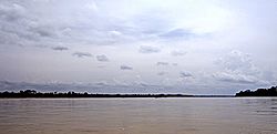
The Napo River to the east of Coca
|
|

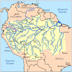
Map of the Amazon Basin with the Napo River highlighted
|
|
| Countries | |
| Physical characteristics | |
| Main source | Cotopaxi in the Andes Ecuador 0°40′S 78°25′W / 0.667°S 78.417°W |
| River mouth | Amazon River 70 km (43 mi) downstream from Iquitos, Loreto Region, Peru 3°27′28″S 72°43′3″W / 3.45778°S 72.71750°W |
| Length | 1,130 km (700 mi) |
| Discharge (location 2) |
7,032.018 m3/s (248,333.4 cu ft/s)
|
| Discharge (location 3) |
(Period: 2001-2005)5,700 m3/s (200,000 cu ft/s) |
| Discharge (location 4) |
(Period: 2001-2005)2,227 m3/s (78,600 cu ft/s)
|
| Basin features | |
| Basin size | 103,307.79 km2 (39,887.36 sq mi) |
| Tributaries | |
The Napo River (which is Río Napo in Spanish) is a very important river in South America. It flows through the countries of Ecuador and Peru. This river is a major tributary (a smaller river that flows into a larger one) of the huge Amazon River.
The Napo River starts high up in the Andes mountains in Ecuador. It begins on the slopes of big volcanoes like Antisana, Sincholagua, and Cotopaxi. The river is about 1,130 kilometers (702 miles) long. It drains a large area of land, covering about 103,307 square kilometers (39,887 square miles).
Contents
Exploring the Napo River's Journey
The Napo River's journey begins in the high Andes mountains. It flows through dense, wet, and rugged areas. Many small streams join the Napo as it leaves the mountains. These streams come from places where plants grow very thickly.
Rivers Joining the Napo
From the north, the Napo River gets water from the Coca River. The Coca River starts near the Cayambe volcano on the equator. Another strong river, the Aguarico River, also joins from the north. Its source is between Cayambe and the border with Colombia.
From the west, the Curaray River flows into the Napo. The Curaray also comes from the Andes mountains. It starts between the Cotopaxi and Tungurahua volcanoes.
From where the Coca River joins, all the way to the Curaray River, the Napo has many obstacles. There are sunken logs and sandbanks. The river also has many islands covered in thick jungle. During the wet season, these islands get flooded. This makes the river incredibly wide.
After the Coca River, the Napo flows through a flat, forested plain. You won't see any hills from the river here. The river banks are very flat, with only swamps and lagoons breaking the view.
The Napo River is easy to travel by boat from the Amazon River up to the Curaray River. This distance is about 216 kilometers (134 miles). It might even be possible to go a bit further. For adventurous travelers, canoes can go even higher up the river. They can reach Santa Rosa. This is usually where people start their journey down from the Quito plateau.
The Coca River can also be explored by boat. However, its middle part is squeezed between two mountain walls. It flows through a deep canyon with high waterfalls and many rocky areas. This part of the Coca River became famous from the expedition led by Gonzalo Pizarro long ago.
River Flow and Water Levels
The Napo River's water level and how much water flows through it changes throughout the year. This is called its "discharge." Scientists measure this to understand the river better. For example, near Bellavista in Peru, the average amount of water flowing through the river is about 6,660 cubic meters per second. That's a lot of water!
The river's flow can be very different between the dry and wet seasons. During the wet season, much more water flows down the river. This can cause the river to become very wide and flood some areas.
See also
 In Spanish: Río Napo para niños
- Lake Pilchicocha
 | Janet Taylor Pickett |
 | Synthia Saint James |
 | Howardena Pindell |
 | Faith Ringgold |


