Moose River (Ontario) facts for kids
Quick facts for kids Moose River |
|
|---|---|

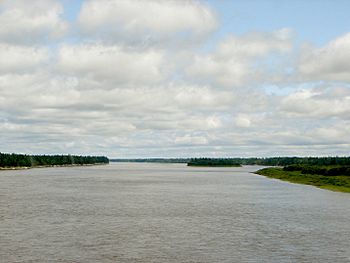
Moose River as seen from the ONR railway bridge
|
|
|
Location of the mouth of the Moose River in Ontario.
|
|
| Country | Canada |
| Province | Ontario |
| District | Cochrane |
| Physical characteristics | |
| River mouth | James Bay 17 km NE from Moosonee 51°21′02″N 80°23′57″W / 51.35056°N 80.39917°W |
| Length | 104 km (65 mi) |
| Basin features | |
| Basin size | 108,500 km2 (41,900 sq mi) |
The Moose River is a large river in northern Ontario, Canada. It flows through a special natural area called the Hudson Plains ecozone. This ecozone is a flat, wet region with many wetlands.
The river itself is about 100 km (62 mi) long. It starts where two other rivers, the Mattagami and Missinaibi Rivers, join together. This joining point is called a confluence. From there, the Moose River flows northeast until it reaches James Bay.
The area of land that drains water into the Moose River is huge. It covers about 108,500 square kilometers (41,900 sq mi). This is called its drainage basin. The river also carries a lot of water, with an average flow of 1,370 cubic meters (48,000 cu ft) every second. If you measure its full length from the very start of the Mattagami River, the Moose River system is about 547 km (340 mi) long.
Long ago, the Moose River was an important water path. It was used by people involved in the fur trade to travel to Lake Superior. A famous fur trading post called Moose Factory was built near the river's mouth. This was one of the first English settlements in Ontario. Today, the town of Moosonee is on the north bank of the river. It is the end point for the Polar Bear Express train, which starts in Cochrane, Ontario.
Contents
Rivers that Join the Moose River
Many smaller rivers flow into the Moose River. These are called its tributaries. Here are some of them:
- North French River
- Kwetabohigan River
- Chimahagan River
- Abitibi River
- Little Abitibi River
- Frederick House River
- Black River
- Lake Abitibi
- Cheepash River
- Renison River
- Mattagami River
- Missinaibi River
- Brunswick River
- Fire River
- Hay River
- Mattawitchewan River
- Albany Forks
- Oba River, Oba Lake
- Albany Forks
- Pivabiska River
- Opasatika River
- Soweska River
Moose River Bird Sanctuary
At the mouth of the Moose River, there is a special place for birds called the Moose River Bird Sanctuary. This sanctuary includes Ship Sands Island and some land on the eastern side of the river's mouth. It covers about 14.60 square kilometers (5.64 sq mi).
This area is protected by law to help migratory birds. It is part of a larger wetland area called the Southern James Bay wetland complex. This complex was recognized as a very important wetland in 1987.
The sanctuary is vital for many kinds of waterfowl (birds that live near water). When birds migrate from the Arctic each autumn, the shape of Hudson and James bays acts like a funnel. This causes many birds to gather at the southern end of James Bay. The large wetlands here are perfect places for them to rest, feed, and molt (change their feathers). Many birds use this area, including lesser snow geese, dabbling ducks, and shorebirds like red knots, short-billed dowitchers, and dunlins.
The Small Settlement of Moose River
There is a small community called Moose River along the Polar Bear Express railway line. It is located at mile 142, just before a large railway bridge that crosses the Moose River. This stop is a "flag stop," meaning the train only stops if someone wants to get on or off.
In the 1930s, when the Moose River bridge was built, this settlement was much bigger. Today, it is a smaller community. The train stop is mainly used by the people who live there. It is also a convenient place for boaters to get on or off the train.
See also
 In Spanish: Río Moose (Ontario) para niños
 | Aaron Henry |
 | T. R. M. Howard |
 | Jesse Jackson |


