Kapuskasing River facts for kids
Quick facts for kids Kapuskasing River |
|
|---|---|

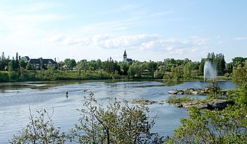
Kapuskasing River in the town of Kapuskasing
|
|
|
Location of the mouth of the Kapuskasing River in Ontario
|
|
| Other name(s) | Rivière de Kapuskasing |
| Country | Canada |
| Ontario | Ontario |
| Region | Northeastern Ontario |
| Districts |
|
| Physical characteristics | |
| Main source | Kapuskasing Lake Kapuskasing Township, Algoma District 312 m (1,024 ft) 48°31′01″N 82°53′51″W / 48.51694°N 82.89750°W |
| River mouth | Mattagami River Clay Township, Cochrane District 195 m (640 ft) 49°48′31″N 82°00′10″W / 49.80861°N 82.00278°W |
| Basin features | |
| River system | James Bay drainage basin |
| Tributaries |
|
The Kapuskasing River is a river found in northern Ontario, Canada. It flows through the Cochrane District and Algoma District. This river is part of the James Bay drainage basin, which means its waters eventually flow into James Bay. It is a branch, or "tributary," of the Mattagami River.
Contents
Journey of the Kapuskasing River
The Kapuskasing River starts its journey at Kapuskasing Lake. This lake is located in Kapuskasing Township, within the Algoma District. It begins near the town of Elsas, where a main railway line passes by.
As the river flows, it heads northeast. It meets the Nemegosenda River, which joins it from the right. The Kapuskasing River then flows over several exciting spots like Jackpine Rapids, Loon Rapids, Buchan Falls, and Clouston Rapids. Further along, the Dunrankin River also joins it.
The river continues north, passing over Cedar Rapids, Woman Falls, and Old Woman Falls. It then moves from the Algoma District into the Cochrane District.
Reaching the Town of Kapuskasing
The Kapuskasing River keeps flowing northeast. It goes over White Otter Falls, Bakatase Falls, Camp Three Rapids, and Big Beaver Falls. The Saganash River then joins it from the right.
Finally, the river reaches the town of Kapuskasing. Here, it flows under Ontario Highway 11 and the Ontario Northland Railway line. In the town, it passes over a hydro dam and Spruce Falls. The Lost River joins from the left, and the Remi River joins from the right.
The Kapuskasing River ends its long journey by flowing into the Mattagami River. This meeting point is about 30 kilometres (19 mi) west of the community of Fraserdale. The Mattagami River then carries these waters further north, eventually reaching the Moose River, which empties into James Bay.
Rivers Joining the Kapuskasing
Many smaller rivers and creeks flow into the Kapuskasing River along its path. These are called tributaries.
- Tucker Creek (right)
- Torrance Creek (right)
- Hopkins Creek (left)
- Remi River (right)
- Lily Creek (right)
- Lost River (left)
- O'Brien Creek (right)
- Teetzel Creek (left)
- Gough Creek (right)
- Saganash River (right)
- Big Beaver Creek (left)
- Alder Creek (right)
- Pinette Creek (right)
- Shanly Creek (right)
- Graveyard Creek (left)
- Moss Creek (left)
- Oscar Creek (left)
- Allenby Creek (right)
- Wigwam Creek (left)
- MacIntosh Creek (right)
- Dunrankin River (left)
- Nemegosenda River (right)
- Kapuskasing Lake
- Chapleau River
Fun on the River
The Kapuskasing River is a popular spot for fishing! Every year, a special fishing competition called the Kapuskasing River Walleye Tournament takes place here. It's part of the Northern Ontario Walleye Trail. This tournament happens on a 40-kilometre (25 mi) section of the river, starting from where it meets the Mattagami River and going upstream.
People have also worked to help the river's environment. More than 20,000 pounds (9,100 kg) of wild rice was brought back and planted in the Kapuskasing River. This helps the local ecosystem and provides food for wildlife.
Protecting the River
For a while, there were plans to build several power plants along the Kapuskasing River. These plants would have used the river's flow to create hydroelectric power. The plans suggested building four power stations south of the town of Kapuskasing. They would have been located at Big Beaver Falls, Camp Three Rapids, White Otter Falls, and Old Woman Falls.
However, a group called the Ontario Rivers Alliance and its members worked hard to protect the river. They were concerned about the impact these projects might have. Because of their efforts, the contracts for these power plants were stopped in 2015. This means that these four sections of the Kapuskasing River were saved from development. In total, 10 rivers in Ontario were protected from similar projects thanks to these actions.
See also
 In Spanish: Río Kapuskasing para niños
 | Precious Adams |
 | Lauren Anderson |
 | Janet Collins |


