
Groundhog River facts for kids
Quick facts for kids Groundhog River |
|
|---|---|

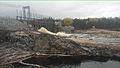
Carmicheal hydroelectric dam
|
|

Location of the mouth of the Groundhog River in Ontario
|
|
| Other name(s) | Rivière Groundhog |
| Country | Canada |
| Province | Ontario |
| Region | Northeastern Ontario |
| Districts |
|
| Physical characteristics | |
| Main source | Horwood Lake Keith Township, Sudbury District 336 m (1,102 ft) 48°06′00″N 82°16′13″W / 48.10000°N 82.27028°W |
| River mouth | Mattagami River Clay Township, Cochrane District 191 m (627 ft) 49°43′04″N 81°58′04″W / 49.71778°N 81.96778°W |
| Basin features | |
| River system | James Bay drainage basin |
| Tributaries |
|
The Groundhog River is a river located in Ontario, Canada. It flows through the Cochrane District and Sudbury District in the northeastern part of the province. This river is part of the larger James Bay drainage basin, which means its water eventually flows into James Bay. It is also a left tributary of the Mattagami River, joining it from the left side.
Where the River Flows
The Groundhog River starts at Horwood Lake in Keith Township, which is in the northern part of the Sudbury District. From there, it flows northeast over the Horwood Lake Dam. This dam helps control the water flow and stores water. The stored water is used for making hydroelectricity (power from water) at stations further down the river.
The river then reaches Groundhog Lake. After that, it flows north under the Canadian National Railway's main train line that crosses Canada. This happens near a small railway stop called Groundhog River. This spot is between the railway stop of Joburke to the west and the community of Kukatush to the east. Even though Via Rail's "Canadian" trains use this line, they do not stop at these small places.
The Groundhog River continues flowing north under Ontario Highway 101. It passes over the Upper Falls and several other unnamed waterfalls. Then, it enters the Cochrane District in Enid Township. It keeps flowing north through the Flying Post 73 Indian Reserve, which is part of the Flying Post First Nation. Along this path, it goes over more unnamed waterfalls.
The river then turns west for a bit, then north again. It flows over the Six Mile Rapids and takes in water from two other rivers: the Ivanhoe River (a left tributary) and the Nat River (a right tributary). The Groundhog River turns west again and takes in the Otapingshewee River, another left tributary.
It then heads north through the Ten Mile Rapids. It passes over the Carmichael Falls Generating Station and its dam. Here, it also takes in the Wakusimi River, which is a left tributary. The river flows around Bremner Island and reaches the community of Fauquier. This community is in the township of Fauquier-Strickland. At Fauquier, Ontario Highway 11 and the Ontario Northland Railway's secondary main line cross the river. This railway line used to be a secondary line for the Canadian National Railway. It was originally the main line for the National Transcontinental Railway.
The Groundhog River continues flowing north around several small islands. It passes the Dixon Rapids, Hamilton Rapids, and La Duke Rapids. It also flows over the Whist Falls. Finally, it reaches its mouth (where it ends) at the Mattagami River in Clay Township. The Mattagami River then flows into the Moose River, which eventually empties into James Bay.
Rivers Joining the Groundhog
Many smaller rivers and creeks flow into the Groundhog River. These are called tributaries. Here are some of them:
- Beardmore Creek (joins from the right)
- Gauthier Creek (joins from the left)
- Wellington Creek (joins from the right)
- Nansen Creek (joins from the left)
- Bremner Creek (joins from the left)
- Wakusimi River (joins from the left)
- South Creek (joins from the right)
- Stringer Creek (joins from the right)
- Slack Creek (joins from the left)
- Hicks Creek (joins from the right)
- Otapingshewee River (joins from the left)
- Nat River (joins from the right)
- Montcalm Creek (joins from the right)
- Ivanhoe River (joins from the left)
- Scorch Creek (joins from the left)
- Vimy Creek (joins from the left)
Images for kids
-
Carmicheal hydroelectric dam
