
Missinaibi River facts for kids
Quick facts for kids Missinaibi River |
|
|---|---|

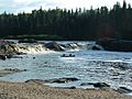
Thunderhouse Falls
|
|
| Country | Canada |
| Province | Ontario |
| Districts |
|
| Physical characteristics | |
| Main source | Missinaibi Lake 12 km SSW from Peterbell inside the Chapleau Crown Game Preserve, Algoma District 48°29′56″N 83°25′52″W / 48.49889°N 83.43111°W |
| River mouth | Moose River Unorg. Cochrane District 50°44′08″N 81°28′02″W / 50.73556°N 81.46722°W |
| Length | 426 km (265 mi) |
| Basin features | |
| Basin size | 23,500 km2 (9,100 sq mi) |

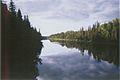
The Missinaibi River is a long river in northern Ontario, Canada. It starts at Missinaibi Lake, north of Chapleau. The river then flows northeast and joins the Moose River. Finally, the Moose River empties into James Bay.
Including Missinaibi Lake and the Moose River, this waterway stretches for about 755 kilometres (469 mi). It is one of Ontario's longest rivers that flows freely. This means it doesn't have many dams or major changes from human activity.
The name "Missinaibi" comes from the Cree language. It means "pictured waters." This name likely refers to the pictographs, or ancient rock paintings, that can be seen along the riverbanks.
Near a spot called Thunderhouse Falls, the river drops about 40 metres (130 feet). This area has many small waterfalls and fast-moving rapids. It marks where the river flows from the high Canadian Shield down to the lower lands near Hudson Bay.
Contents
River History and Fur Trade
The Missinaibi River was very important a long time ago. During the fur trade era, it was a main travel route. People used it to move furs and supplies between James Bay and Lake Superior.
The usual path was:
- From James Bay to Moose Factory
- Then along the Moose River (Ontario)
- Up the Missinaibi River to Missinaibi Lake
- A short portage (carrying boats over land) to Dog Lake
- Down the Michipicoten River to Fort Michipicoten on Lake Superior
English traders from the north and French traders from the south both wanted control of this route. In 1774, the Hudson's Bay Company started building trading posts inland. These posts were like small forts where traders could live and trade with Indigenous peoples.
Important Trading Posts
Over time, three main trading posts were set up along the route. They were sometimes called Brunswick House.
- Wapiscogamy House: This post was built in 1776 by Thomas Atkinson. It was on the west bank of the river. It was rebuilt in 1781 and called Brunswick House. It closed and reopened a few times.
- Missinaibi Lake House: In 1777, John Thomas built a post at the start of the Missinaibi River, near Missinaibi Lake. It was used every summer until it burned down in 1780. It was reopened later and renamed New Brunswick House in 1879. When a railroad was built nearby in 1912, the post moved to Peterbell and closed in 1914.
- Macabanish House: William Boland started this post in 1788. It was on Micabanish Lake, a small lake connected to the river. This post became very successful. In 1799, it was named New Brunswick House. The Brunswick House First Nation gets its name from these historic trading posts.
Modern River Use
Today, the Missinaibi River is a popular spot for outdoor activities. People enjoy canoeing, fishing, and camping here. It's a great place for adventurers!
One cool thing is that canoeists can put their boats on a train. This helps them get back south after paddling the wild parts of the river.
The river is protected as a provincial waterway park. In 2004, it was named a Canadian Heritage River. This means it's recognized for its natural beauty and history.

River Branches (Tributaries)
Many smaller rivers and streams flow into the Missinaibi River. These are called tributaries. Some of them include:
- Brunswick River
- Fire River
- Greenhill River
- Hay River
- Mattawitchewan River
- Albany Forks
- Oba River, Oba Lake
- Albany Forks
- Pivabiska River
- Opasatika River
- Soweska River
-
Missinaibi River
-
Glassy Falls


Missinaibi Provincial Park
| Missinaibi Provincial Park | |
|---|---|
|
IUCN Category II (National Park)
|
|
| Location | Ontario, Canada |
| Nearest city | Mattice |
| Area | 990.90 km2 (382.59 sq mi) |
| Established | 1970, enlarged in 1989 |
| Governing body | Ontario Parks |
The entire Missinaibi River is part of the Missinaibi Provincial Park. This park protects the river from Missinaibi Lake all the way to the Moose River. The park also includes Missinaibi Lake and other nearby lakes and rivers.
The park was created in 1970 and is very large. It covers over 991 square kilometres (383 square miles) of wild nature.
Even though not many people visit, it's very famous among canoeists. It's often called a "must-visit" place for paddling adventures.
Canoeing Routes
There are two main routes for paddlers in the park:
- Missinaibi River Route: This route is about 238 kilometres (144 miles) long. It goes from the town of Missinabie to Mattice.
- Mattice to Moosonee Route: This longer route is about 316 kilometres (190 miles). It takes paddlers all the way to the edge of James Bay, near the Arctic region.
Other Park Activities
Besides canoeing, you can enjoy other activities at Missinaibi Provincial Park:
- Hiking on trails
- Fishing in the river and lakes
- Camping in the wilderness
- Watching wildlife like birds and animals
- Hunting (in designated areas)
