
Abitibi River facts for kids
Quick facts for kids Abitibi River |
|
|---|---|

Abitibi River at Iroquois Falls
|
|

Location of the mouth of the Abitibi River in Ontario
|
|
| Country | Canada |
| Province | Ontario |
| District | Cochrane |
| Physical characteristics | |
| Main source | Lake Abitibi 38 km east of Iroquois Falls 48°47′06″N 80°10′23″W / 48.78500°N 80.17306°W |
| River mouth | Moose River 30 km SSW from Moosonee 51°04′17″N 80°55′32″W / 51.07139°N 80.92556°W |
| Length | 540 m (1,770 ft)to head of Lac Loïs |
| Basin features | |
| Basin size | 29,500 km2 (11,400 sq mi) |
| Tributaries |
|
The Abitibi River is a long river in northeastern Ontario, Canada. It flows from Lake Abitibi towards the northwest. Eventually, it joins the Moose River, which then empties into James Bay. This river is about 540 kilometres (340 mi) (336 miles) long. Along its path, the river drops about 265 metres (869 ft) (869 feet) in height.
The name "Abitibi" comes from the Algonquin language. It means "halfway water." This name was first used by the French to describe a group of Algonquin people. These people lived near the lake, halfway between trading posts on Hudson Bay and those on the Ottawa River.
This river was once a very important route for the Hudson's Bay Company. They used it for trading furs. In the past, making pulp and paper was a big industry in the area. This industry was mainly in the town of Iroquois Falls. Today, people also enjoy tourism and gold mining in the region.
Contents
Hydroelectric Power
The Abitibi River is home to several power plants that use the river's flow to make electricity. One of these is the Abitibi Canyon Generating Station. It is located at Abitibi Canyon, Ontario.
A famous folk singer named Wade Hemsworth was inspired by this area. He surveyed the river for the power plant project. This experience led him to write his well-known song, "The Black Fly Song."
Rivers Joining the Abitibi
Many smaller rivers flow into the Abitibi River. These are called its tributaries.
- Little Abitibi River
- Frederick House River
- Black River
Where the River Flows
The Abitibi River starts as the outlet from Lake Abitibi. It then flows past several places and landmarks:
- It flows near Iroquois Falls.
- It is crossed by the Ontario Northland Railway.
- The river has hydroelectric plants like the Long Sault Rapids plant.
- It meets the Black River.
- Further downstream, it meets the Frederick House River.
- It flows past Island Falls, Ontario.
- The Abitibi Canyon Generating Station is located near Fraserdale, Ontario.
- Another power plant, the Otter Rapids Generating Station, is also on the river.
- Finally, the Abitibi River joins the Moose River. The Moose River then flows into James Bay.
Images for kids
-
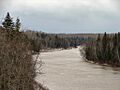
The Abitibi River at Iroquois Falls.
-
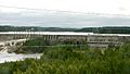
The Otter Rapids Dam as seen from the ONR railway.

See also
 In Spanish: Río Abitibi para niños
