Harricana River facts for kids
Quick facts for kids Harricana |
|
|---|---|

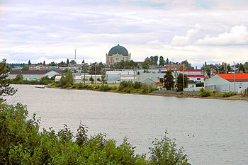
The Harricana River in Amos
|
|

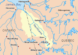
Harricana River basin in yellow
|
|
| Country | Canada |
| Provinces | |
| Physical characteristics | |
| Main source | Lake Blouin Val-d'Or, Jamésie, Quebec 48°11′45″N 77°44′50″W / 48.19583°N 77.74722°W |
| River mouth | Hannah Bay off James Bay 60 km east of Moosonee, Ontario 0 m (0 ft) 51°10′00″N 79°47′30″W / 51.16667°N 79.79167°W |
| Length | 533 km (331 mi) |
| Basin features | |
| Basin size | 29,300 km2 (11,300 sq mi) |
The Harricana River (also called Rivière Harricana in French) is a long river in Canada. It flows through western Quebec and a small part of northeastern Ontario. The river is about 533 kilometers (331 miles) long. It drains an area of 29,300 square kilometers (11,300 sq mi).
Most of the river's drainage area (80%) is in Quebec. However, the Harricana flows into Hannah Bay, which is part of James Bay. This bay is located off the coast of Ontario. Because the river is mostly untouched by human development, it's a popular spot for canoeing trips. People can easily start their journey upstream and finish near Moosonee.
Contents
River's Journey: Geography
The Harricana River starts at Lake Blouin, just north of Val-d'Or in Quebec. As it flows, other lakes like De Montigny and Lemoine add water to it. The river then passes through a series of lakes. These include Malartic, La Motte, and Figuery Lakes.
After flowing through the town of Amos, the river meets one more important lake: Lake Obalski. North of Amos, the Harricana goes through thick boreal forests. These forests are where a lot of logging (cutting down trees) happens.
Closer to where the river meets Hannah Bay, the forests become less dense. Instead, you'll see many wetlands (areas of land covered by water). In this area, the Harricana flows quickly through wild, undeveloped land.
Rivers Joining the Harricana
Here are some of the rivers that flow into the Harricana, listed in order from upstream to downstream:
- Berry River
- Desboues River
- Miniac River
- Octave River
- Coigny River
- Plamondon River
- Samson River
- Turgeon River
- Theo River
- Wawagosic River
- Kesagami River
Harricana River: A Look at History

The Algonquins, who are Indigenous people, were the first to use the Harricana River as a travel route.
The Harricana River and the land around it were once part of Rupert's Land. This huge area was practically owned by the Hudson's Bay Company starting in 1670. This company was a fur trading business.
In 1801, Alexander MacKenzie, an explorer, was the first to map the entire river. He also gave it the name Harricanaw. Later, in 1835, a map by Bradford called it Harricana.
In 1868, the Rupert's Land Act 1868 transferred the river and its basin to Canada. It officially became part of the Province of Quebec in 1898. After this, people began to settle and build communities along the upper parts of the Harricana.
In 1906, Henry O' Sullivan explored the river's shores. By 1908, the first camps were set up along its banks. These camps provided supplies for building the transcontinental railroad. A few years later, in 1910, the first settlers arrived. They founded the town of Amos where the railroad crosses the river.
What's in a Name: Toponymy
The name of the river comes from the Algonquin word Nanikana. This word can mean "the main way" or "Biscuit River."
The "Biscuit River" meaning refers to unusual flat stones found in the river. These stones are made of sand, limestone, and clay. They look a bit like bannock, a type of flat bread. People sometimes call these stones Pierres de fée, which means "fairy stones."
Over time, the name has been spelled in different ways. The Algonquins also used the name Inikana, meaning "river route." A part of the river was called Waashahaau Siipii by the East James Bay Cree people. This name means "river to the bay."
See also
 In Spanish: Río Harricana para niños
 | Sharif Bey |
 | Hale Woodruff |
 | Richmond Barthé |
 | Purvis Young |


