Turgeon River (Harricana River tributary) facts for kids
Quick facts for kids Turgeon |
|
|---|---|

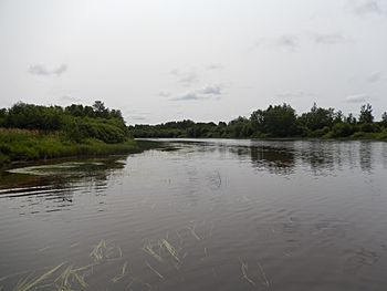
Turgeon River at Val-Paradis toward head of river
|
|

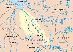
Harricana River basin in yellow
|
|
| Country | Canada |
| Provinces | |
| Physical characteristics | |
| Main source | Lake Turgeon (Eeyou Istchee Baie-James) Eeyou Istchee Baie-James (municipality), Nord-du-Québec, Quebec 288 m (945 ft) 49°00′53″N 79°03′48″W / 49.01472°N 79.06333°W |
| River mouth | Harricana River Eeyou Istchee Baie-James, Quebec 223 m (732 ft) 50°00′30″N 78°55′58″W / 50.00833°N 78.93278°W |
| Length | 216.6 km (134.6 mi) |
| Basin features | |
| Tributaries |
|
The Turgeon River is a long river in Canada. It flows mostly through the Eeyou Istchee Baie-James (municipality) area in Quebec. This river is a branch, or "tributary," of the Harricana River. The Harricana River then flows into the southern part of James Bay.
Contents
The Turgeon River's Journey
The Turgeon River starts at a place called Lake Turgeon. This lake is about 9.1 kilometers (5.7 miles) long. It sits partly in the Abitibi-Temiscamingue region and partly in the Nord-du-Québec region.
From Lake Turgeon, the river flows for about 62.3 kilometers (38.7 miles). It winds its way south, west, and then northwest. Along this path, it meets the Boivin River. After that, it continues northwest for 3.5 kilometers (2.2 miles) to Orfroy Creek. Then, it travels another 29.0 kilometers (18.0 miles) northwest until it reaches the border of Ontario.
Crossing into Ontario
The Turgeon River takes a short trip into Ontario for about 6.7 kilometers (4.2 miles). While in Ontario, it collects water from two other rivers: the Burntbush River and the Patten River.
After its detour into Ontario, the river turns northeast and flows back into Quebec. It continues for 8.7 kilometers (5.4 miles) there. Then, it heads north for about 49.3 kilometers (30.6 miles). During this part of its journey, it flows alongside the border between Quebec and Ontario. It stays about 6 to 7 kilometers (3.7 to 4.3 miles) away from the border. In this section, the river goes through the Rivers-Forests Areas for 15.2 kilometers (9.4 miles). Here, you can find a place called Kapipawesig Island.
Final Stretch to Harricana River
Next, the Turgeon River collects water from the Detour River. It then turns east and flows for 34 kilometers (21 miles). It makes a big loop to the south before meeting the Wawagosic River. Finally, the river flows 13.1 kilometers (8.1 miles) east. It then joins the Harricana River. The place where the Turgeon River ends is in the Eeyou Istchee Baie-James (municipality) area.
Main Rivers Joining Turgeon
Many smaller rivers and creeks flow into the Turgeon River. These are called its "tributaries." Some of the main ones include:
- Leslie Creek (in Quebec)
- Boivin River (in Quebec)
- Burntbush River (in Ontario)
- Patten River (in Quebec and Ontario)
- Detour River (in Ontario and Quebec)
- Wawagosic River (in Quebec)
Towns Along the River
The Turgeon River flows near a few towns, including:
- Villebois, Quebec
- Valcanton, Quebec
History of the Turgeon River Area
Long ago, before people from Europe arrived, the Algonquin people lived in the lands around the Turgeon River. The area was covered in thick forests.
In the 1930s, something big happened. Many people in Canada lost their jobs because of a worldwide economic problem. They came to this area hoping to start new lives. Back then, there were no roads. People traveled across the valley using barges, which are flat-bottomed boats, by following the river.
Founding New Communities
During the 1930s, three new communities were started in the area: Saint-Joachim-de-Beaucanton, Saint-Camille-de-Villebois, and Saint-Ephrem-de-Val-Paradis. Today, Beaucanton and Val-Paradis have joined together to form Valcanton, Quebec. These villages are now part of the huge Eeyou Istchee Baie-James (municipality), which is one of the largest municipalities in the world!
In the 1940s and 1950s, several covered bridges were built in the Turgeon Valley. These special bridges had roofs and walls. You can still visit five of them today: three are over the Turgeon River itself, and two are over its smaller branch rivers.
How the River Got its Name
The study of how places get their names is called "toponymy." Both Lake Turgeon and the Turgeon River were named after a government official. His name was Adélard Turgeon, and he was the Minister of Lands and Forests in 1908.
The Indigenous people who lived there first had a different name for the lake. They called it Nikikwatinipi, which means "Lac Frimas" (Frost Lake). The name "rivière Turgeon" was officially recorded on December 5, 1968, by the Commission de toponymie du Québec, which is the official group that names places in Quebec.
 | Mary Eliza Mahoney |
 | Susie King Taylor |
 | Ida Gray |
 | Eliza Ann Grier |

