Burntbush River facts for kids
Quick facts for kids Burntbush |
|
|---|---|

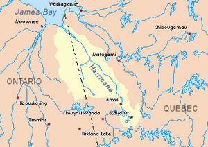
Harricana River basin in yellow
|
|
| Country | Canada |
| Province | Ontario |
| District | Cochrane |
| Physical characteristics | |
| Main source | Cochrane District, Ontario 304 m (997 ft) 49°36′54″N 80°15′14″W / 49.61500°N 80.25389°W |
| River mouth | Turgeon River Cochrane District, Ontario 259 m (850 ft) 49°27′51″N 79°32′42″W / 49.46417°N 79.54500°W |
| Length | 93.1 km (57.8 mi) |
| Basin features | |
| Tributaries |
|
The Burntbush River is a river in Ontario, Canada. It's like a smaller branch that flows into the Turgeon River. The Turgeon River then joins the bigger Harricana River. The Harricana River mostly flows through Quebec before crossing back into Ontario and finally emptying into the southern part of James Bay. The Burntbush River itself starts in the Cochrane District in Northeastern Ontario.
The Burntbush River's Journey
The Burntbush River is surrounded by many other rivers and land areas.
- To the north: You'll find the Chabbie River, Lawagamau River, and Detour River.
- To the east: Is the Turgeon River, which flows through both Ontario and Quebec.
- To the south: Are rivers like the Mikwam River, Little Mikwam River, Porphyry Creek, Kabika River (Ontario), and East Kabika River.
- To the west: You'll see the Kesagami River, Wekweyaukastik River, little Wekweyaukastik River, and North French River.
The Burntbush River begins at a place called Upper Burntbush Lake. This lake is about 1.8 kilometres (1.1 mi) long. It sits 304 metres (997 ft) above sea level. The very beginning of the river is located south of Lawagamau Lake. It is also east of Ontario Highway 652.
From Upper Burntbush Lake, the river flows for about 13.1 kilometres (8.1 mi) to the east. Then, it turns north for 3.0 kilometres (1.9 mi) towards Singer Lake. After another 1.9 kilometres (1.2 mi), the Burntbush River gets more water from the North Burntbush Lake. The river then continues for 17.9 kilometres (11.1 mi) until it reaches the north shore of Burntbush Lake. Burntbush Lake also receives water from Soucie and East Soucie lakes. The river flows right through Burntbush Lake for its full length, which is about 3.6 kilometres (2.2 mi) to the southeast.
The river then continues flowing southeast for about 29.6 kilometres (18.4 mi). Here, it meets the Kabika River (Ontario). The Kabika River brings water from the Kabika East River and other smaller streams. After this, the Burntbush River turns northeast for 24 kilometres (15 mi). It passes south of Mollet Lake, which is surrounded by marshy areas. Finally, the Burntbush River flows into the Turgeon River.
The spot where the Burntbush River joins the Turgeon River is interesting. It's about 2.0 kilometres (1.2 mi) west of the border between Ontario and Quebec. It's also 0.6 kilometres (0.37 mi) north of where the Patten River joins. This meeting point is 3.5 kilometres (2.2 mi) downstream from where the Turgeon River first crosses the Ontario-Quebec border. It is also 3.6 kilometres (2.2 mi) upstream from where the Turgeon River crosses the border a second time.
What's in a Name?
The names "Upper Burntbush Lake," "North Burntbush Lake," "Burntbush Lake," and "Burntbush River" all come from the same origin. They are all connected to the same geographical area.
 | James Van Der Zee |
 | Alma Thomas |
 | Ellis Wilson |
 | Margaret Taylor-Burroughs |

