Mikwam River facts for kids
Quick facts for kids Mikwam |
|
|---|---|

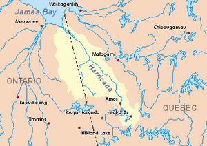
Harricana River basin in yellow
|
|
| Country | Canada |
| Province | Ontario |
| District | Cochrane |
| Physical characteristics | |
| Main source | Cochrane District, Ontario 343 m (1,125 ft) 49°43′16″N 79°56′39″W / 49.72111°N 79.94417°W |
| River mouth | Turgeon River Cochrane District, Ontario 271 m (889 ft) 49°27′51″N 79°32′42″W / 49.46417°N 79.54500°W |
| Length | 87.8 km (54.6 mi) |
| Basin features | |
| Tributaries |
|
The Mikwam River is a river in Ontario, Canada. It flows into the Burntbush River. You can find it in the Cochrane District in northeastern Ontario.
The main activities in this area are forestry, which means cutting down trees for wood, and tourism. People visit for fun activities like exploring nature. Ontario Road 652 runs along the west side of the river's area.
The Mikwam River usually freezes over in early November. It stays frozen until mid-May. It's generally safe to walk or travel on the ice from mid-November to the end of April.
Contents
Where Does the Mikwam River Flow?
The Mikwam River starts from a mountain stream. This stream is about 343 meters (1,125 feet) high.
The river flows for about 87.8 kilometers (54.6 miles). It travels through different areas before joining another river.
Mikwam River's Journey
The river's path includes several sections:
- It flows about 7.4 km (4.6 mi) south. It passes a mountain that is 391 meters (1,283 feet) tall.
- Next, it goes 9.9 km (6.2 mi) northeast. It forms an "S" shape as it enters Newman Township. Here, it meets the East Mikwam River.
- Then, it flows 5.0 km (3.1 mi) north through marshy areas. It reaches the south shore of Snare Lake.
- The river continues 12.4 km (7.7 mi) north. This includes crossing Springer Lake for 3.3 km (2.1 mi). It then reaches the southern edge of Blakelock Township.
- It flows 12.8 km (8.0 mi) north, crossing Lake Magishan. It also crosses Lake Mikwam for 4.7 km (2.9 mi). Lake Mikwam receives water from Brayley Lake and the Little Mikwam River.
- Finally, it travels 18.0 km (11.2 mi) northeast. It then turns southeast as it enters Hoblitzell Township. Here, it meets Porphyry Creek.
Where the Mikwam River Ends
The Mikwam River joins another river in Hoblitzell Township. This spot is about 29.3 km (18.2 mi) west of the border between Ontario and Quebec. It is also west of where the Burntbush River ends. You can find it southeast of a bay in Kesagami Lake. It is also east of Ontario Road 652.
What's in the Mikwam River Area?
The area around the Mikwam River has many other rivers and lakes. These are all connected to the Mikwam River's water system.
Nearby Rivers and Lakes
Here are some of the rivers and lakes close to the Mikwam River:
- North side: Burntbush River, North Burntbush River, Lawagamau River.
- East side: Burntbush River, Turcotte River.
- South side: South Mikwam River, Little Mikwam River, Porphyry Creek, Kabika River (Ontario), East Kabika River, Seguin River.
- West side: South Floodwood River South, Floodwood River, Little Abitibi River.
What Does "Mikwam" Mean?
The name "Mikwam" is used for many places in the Cochrane District. This shows they are all connected.
Places Named Mikwam
You will find these names in the same area:
- Mikwam River
- Little Mikwam River
- East Mikwam River
- Mikwam Lake
- Little Mikwam Lake
- Upper Mikwam Lake
 | Charles R. Drew |
 | Benjamin Banneker |
 | Jane C. Wright |
 | Roger Arliner Young |

